
Facts
- Elevation: 958 m (3,143 ft)
- Prominence: 910 m
- Peak category:
 Spesial
 - Province:
 Kalimantan Barat (West Kalimantan)
 - Coordinates: -1.0165, 110.3357
- Rating:


 (4 votes) Add your rating
 Loading...
 - Other names: Bukit Unta
Photos
")
")
")
")
")
")
")
")
")
")
")
")
")
")
")
")
Bagging It!
Batu Daya is one of the most iconic mountains in Indonesia but very few people know of its existence. Along with Gunung Kelam (also in West Kalimantan), Puruk Sandukui (Central Kalimantan) and the huge Merabu karst region in East Kalimantan it is an area which is bound to become a major natural tourist attraction in the next couple of decades, particularly if the Indonesian capital is relocated to Kalimantan and local infrastructure improves.
At present, other than oil palm plantation workers, well-read local nature lovers, and international rock climbers very few people seem to know about it. Batu Daya can be seen on flights between Ketapang and Pontianak, and sometimes on descent or ascent to/from Pontianak in clear weather but is totally invisible to users of the Trans-Kalimantan highway which passes within about 25km of it near Sandai. From Ketapang to Sandai takes about 5 hours by road and then it’s a further hour (minimum) through the plantations for the best views of the mountain.
To reach the base of it from Sandai you need to take one of several oil palm plantation roads which are as bumpy as you might expect and have various security checkpoints (Global Palm Resources). You will be waved through if you mention Batu Daya and after about 30 minutes from the main road will be able to see it in the distance. From this perspective, it resembles a giant impenetrable spacecraft about to lift off! It really does live up to its name of ‘Stone of Power’ and you may well be overwhelmed when you first glimpse it.
To get closer to Batu Daya you need to head further in to the plantations towards Pabrik (the palm oil factory) or better still the SMP (Indonesian school which is either no longer used or not for its original purpose). Slowly, it will become apparent that the mountain is comprised of 3 different peaks, all of which offer excellent rock climbing. Given its many different apperarances from different perspectives, no wonder it is also called Bukit Unta (‘camel hill’).
A Japanese rock climber explored this area a couple of years ago (2015?), and allegedly paid locals about 3 million Rupiah for the ceremony before climbing it. This price seems to vary between 1 and 3 million but what factors are taken into consideration by local village chiefs is unclear. They certainly seem to regard it as a sacred mountain that needs sufficient respect, particularly from those wishing to climb. According to the Japanese climber’s research, the three peaks (from west to east or left to right when seen from the south) have the following names and heights: Batu Daya (955m), Kuang Kande (958m) and Belah Hulu (807m). These heights have been taken from US Army Maps of Borneo in 1944 (when Batu Daya was spelt Batoe Dajeuh) but we hope to also have more recent data available soon.
Information by Dan Quinn (August 2017)
Below is a bagging report by Mike Libecki (originally published on the American Alpine Journal website) regarding Batu Daya southeast face.
In 2011, after authorities denied me a visa to return to Socotra Island, Yemen, due to war mayhem, I looked at my long list of areas to explore, with more than 20 expeditions on the docket. Batu Daya caught my eye; I had never been there. The first two weeks of December are in the rainy season, but I decided to go. I arrived at Jakarta and flew to Ketapang. A few hours drive, a few hours on a speed boat, a hitched lift on a big truck working the palm oil fields, and I was near Batu Daya, staring at its massiveness. I made this journey with a local guide and new friend, Herry, from Kalimantan. We paid locals to camp at their house near Batu Daya. As in so many places, these people were wonderful and kind. I had many good meals and laughter with them, but with a roundtrip from home limited to two weeks, there was no time to lose.
Herry and I hacked through the jungle with razor-sharp machetes. It took a few days to reach the base of Batu Daya, some of the worst suffering of my life. Hours of slogging in swamps, razor-wire bushes, 35°C, 95%+ humidity. Jungles are the worst; I would rather freeze. I have been in many jungles, always a sufferfest. Respect to all fellow jungle explorers. Of course, there is something wonderful about suffering: the pay off, survival and/or summit, seems so much better. We had a base camp near the foot of the tower, making beds out of vines and trees. The route looked like it would allow a fast ascent, and Herry asked if I could teach him some rope work, so he could follow me up, as he had always dreamed of going to the summit of Batu Daya.
We left super early and climbed all day. The rock was good and highly featured, with solid jungle foliage and vines to hold. The runouts were quite fun, as everywhere there were sweet holes and pockets in the stone. The worst part was getting to the jungle after the end of bare rock. This jungle was the thickest, most insane, I have ever seen. After four hours of being shredded by the vines and organic razor wire, we reached the summit as the sun disappeared.
Herry was able to light a fire, and we sat waiting for the sun to light our descent. It was a creepy night, and I wiped several bugs and spiders off my neck and face. Next day we reached base camp by nightfall, and the following morning got lost trying to find our way out of the jungle. I got increasingly worried as we spent all day walking through muddy swamps and razor-wire bushes and vines, but 20 minutes before full darkness we stumbled onto an old, barely visible bulldozer trail. Definitely some of the worst suffering I’ve experienced.
Locals say there was a team that tried to climb Batu Daya 10 or 15 years ago, and one climber died. I talked with an elder local who helped carry the body. Other than that I can find no information on attempts or successes. I graded our 650m route on the southeast face V 5.10 A1.
Originally nominated as a Spesial by Chris Whiting.
Practicalities
- Getting there: 6 hours by car to within sight of the mountain from Ketapang, or 8 hours from Pontianak. Lots of flights between Ketapang and Pontianak but some have a 10kg baggage limit. From Ketapang, follow the coast north to Siduk (90min) then take a right inland on a rough, dusty road across to the Trans Kalimantan road via Sungai Kelik. Once on the Trans Kalimantan road turn left (north) towards Pontianak until you reach the Sandai area.
- Permits: Not required if you just want to take photos from afar, but rock climbers will probably have to pay for a traditional good luck ceremony conducted by local shamans prior to climbing. Apparently you need to request permission in Keranji village (30km away from the actual mountain) before staying at Desa Tunas Harapan itself which is just 2km from the rockface).
- Water sources: Unknown – assume none.
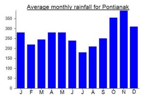
Local Average Monthly Rainfall (mm):
Location
Click on the blue arrow ![]() (top right) to see your current location on the map
(top right) to see your current location on the map
Origins and Meaning
‘Stone of power’ in Indonesian.
After having been refused permission to hike Gunung Niut, I decided that as I had already booked tickets to Pontianak I might aswell give my 2nd choice in Kal Bar a go. I had long wanted to visit this brilliant collection of near vertical cliffs after having been alerted to photos of them on Google Earth.
Flights from Pontianak to Ketapang are frequent and affordable and in clear weather you will have a good chance of spotting Batu Daya from the air. Whilst you can access Batu Daya from Pontianak it takes about 8 hours to the foot of the mountain as opposed to 6 so it’s a good excuse to visit Ketapang – a small, friendly town that sees few tourists except those heading straight to Gn Palung national park. Be aware that on some flights such as Wings the checked baggage limit is 10kg.
So few tourists are seen that you may be offered a free motorbike from curious locals, as I was twice within hours of arriving. As usual in Indonesia it is often a good idea to reject the ‘don’t talk to strangers’ western ideology and say yes to these genuinely kind offers.
Regular ojeks are harder to find and aside from in the supermarket the beer is ridiculously expensive at rp110,000 at the new aston hotel. I stayed behind the Aston at thr affordable and quiet Penginapan Adam.
With a bit of time on my hands I got an ojek down to the Keraton or Sultan’s house – a very pleasant yellow wooden building alongside the river Pawan. There is also the Tugu Ale Ale to see – alas not a monument to local real ale despite the obviously diverse local population but a number of miniroundabout monuments of a similar nature.
I asked about Batu Daya in the Eiger store but didn’t hear back from them after leaving my number. Generally speaking, the staff in Consina shops seem to be much better – often keen hikers who have a good knowledge of local mountains.
I knew I wouldn’t be able to climb the cliffs of Batu Daya, not only because I am not an expert rock climber but also because it would require more time than I had and allegedly between 1 and 3 million for a local traditional good luck ceremony prior to climbing. Just a view of the rock itself would be enough – along with Gunung Kelam and Puruk Sandukui the premier league of awe inspiring cliff faces of all of Kalimantan / Borneo.
After asking around, the best deal I could get was 1.5 juta for a car and driver for 24hrs including everything from Trijaya car rental 0821 5218 0081. Went and had an excellent pizza at Culinary restaurant and arranged for 10.30 am pickup the following day.
Original aim was to photo Batu Daya at sunset and sunrise. The standard way of getting up to the palm oil plantation amongst which Batu Daya lives – and indeed for the 12 hour drive up to Pontianak – is to follow the coast north to Siduk (90min of shuddering, wave-like tarmac!) where you take a right inland and onto a rough, often dusty road that cuts over to the Trans Kalimantan road. This is 2 very bone jarring hours but there are some good views including of Gn Palung mountain range near the start and river views (Pawan again) at Sungai Kelik. When dry the dust is enough to cause you problems even inside the car!
Eventually after a total of 3.5 hours we reached the properly surfaced Trans Kalimantan at Nanga Tayap and headed north.
After another 1.5 hours we pulled in at a warung at a junction at Desa Bungaras (might be spelt differently). Luckily this junction led into the palm oil plantation, though there is more than one route in for sure. The road from here is reasonably quiet except for the occasional truck loaded up with oil palm. From the main road it is over 25km in a straight line to Batu Daya and on this bumpy track it took us an hour just to reach a processing factory still 9km from the mountain.
However, after just 30min from the main road we got our first views of Batu Daya. Quite staggering. A truly beautiful mountain which ought to be world-famous (and may well be ten years from now if Jokowi’s rail plans for Kalimantan are realised.
There are a few checkpoints (global palm resources) but the security men were all friendly when we mentioned Batu Daya and waved us on. Generally you just need to follow the dominant road but you may need to ask for help. We were told ‘pabrik’ (factory) or smp (school) to get us headed in the right direction and took a right at sign to kenjaing and matan.
I am not a fan of oil palm plantations but here it’s the main reason you get such panoramic views of Batu Daya. There is still a lot of birdlife here especially near a bridge over a river.
After this we got a bit lost trying to get to the foot of the mountain. As usual dont trust google maps when it comes to these little remote tracks. There’s only occassional phone signal out here too.
From different angles, Batu Daya looks very different, so no surprise it goes by more than one name (also Bukit Unta). At first it looks like a bulky, impenetrable tower or spaceship. Further along the main track you see it is actually comprised of 3 separate peaks. Beautiful also.
From the factory we tried to get toward the foot of the mountain but deep in the dense oil palm plantations there are multiple tracks crisscrossing each other and no views through.
Given we had limited light left and my main purpose was to get dusk photos we decided to head back to the factory and then retreat further to the spot where we had first seen it. We must have got to within about 5km of the mountain and given the panoramas I was satisfied with that.
Guessing the height of the mountain is a very difficult task. One report suggests around 499m but a report by a Japanese climber who reached the top in the last couple of years states 958m for the tallest of the 3 cliffs.
Getting back to the main road after dark is a difficult matter. I assume you could stay with friendly locals within the plantations if you wanted to. To get back out we followed signs for Sandai and paid some village lads rp50,000 to escort us back out using the most direct route on their motorbikes. We had a flat tyre which is not surprising given the terrain!
Luckiky at the junction there were a couple of nameless bars with beer and bad dangdut music and rather tartily dressed ladies. So I had a drink whilst driver Hary sorted out the flat tyre.
As it would be an hour back in through the palm plantations for dawn and I already had some pretty reasonable photos, we decided to head back to Ketapang that night. Took about 5 hrs from Sandai. I definitely recommend Hary as a driver especially as he knows where it is now. His number is 0823 5241 6885.
We arrived back at 3am and I sorted out a car ride to the airport from Penginapan Adam for a reasonable rp50,000.