
Facts
- Elevation: 1,580 m (5,184 ft)
- Prominence: 491 m
- Peak category:
 Spesial
 - Province:
 Kalimantan Tengah (Central Kalimantan)
 - Coordinates: 0.2608, 113.4284
- Rating:
 (Bagged it? Be the first to rate it)
 Loading...
 - Other names: Betikap
Photos


Bagging It!
Bukit Batikap is one of the northernmost mountains in Central Kalimantan. In 2012, as part of a mapping project with Tumbang Tohan, Heart of Borneo followed three village members to map northernmost reaches of their traditional territory. The pictures above are from that 9 day unsupported expedition. According to Martin Holland of Heart of Borneo, “we want to delve deeper into this amazing, unstudied area of rainforest from next year onwards. Stay tuned for more info…” You can visit the Heart of Borneo page for further information here http://www.heartofborneo.org/our-work/bukit-batikap-2012/ or follow their Facebook page http://facebook.com/BorneoRainforests or Twitter @heart_of_borneo Nominated as a Spesial by Martin Holland of Heart of Borneo
Practicalities
-
- Getting there: Palangkaraya is the closest major airport.
- Permits: Unknown
- Water sources: Unknown
Local Average Monthly Rainfall (mm): 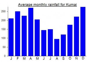
Location
Click on the blue arrow ![]() (top right) to see your current location on the map
(top right) to see your current location on the map