
Facts
- Elevation: 3,016 m (9,895 ft)
- Prominence: 1,587 m
- Ribu category:
 Sangat Tinggi
 - Province:
 Sulawesi Selatan (South Sulawesi)
 - Coordinates: -2.4057, 120.5419
- Rating:

 (7 votes) Add your rating
 Loading...
 - Other names: Baliase
- World Ribus ID: 69071
Bagging It!
We currently know very little about this peak – it has been climbed by students from hiking clubs in Makassar and the trek takes about one week in total.
Apparently the peak called Balease is just 2,894m and the highest peak (3,016m) is known as Gunung Tolangi (or ‘Toelangi’) and is 2 kilometres south of Balease. However, SRTM data suggests that Balease might be higher, so it is best to visit both peaks to be sure until we have the definitive answer!
Practicalities
- Getting there: The closest airport is Palopo which has daily flights to/from Makassar.
- Permits: Unknown
- Water sources: Unknown
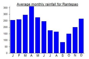
Local Average Monthly Rainfall (mm):
Location
Click on the blue arrow ![]() (top right) to see your current location on the map
(top right) to see your current location on the map
Saya punya data KMZ gunung Balease via Bantimurung dan Tamboke
boleh minta maps nya mas? thankyou
Do you have any GPS or KML File for Baliase?
You can message me if you are still interested. I’ve been there once.
The truth mountain jungle in south sulawesi.