
Facts
- Elevation: 1,340 m (4,396 ft)
- Prominence: 1,340 m
- Ribu category:
 Kurang Tinggi
 - Province:
 Sulawesi Utara (North Sulawesi)
 - Island: Sangihe Besar
- Coordinates: 3.6883, 125.4477
- Rating:

 (7 votes) Add your rating
 Loading...
 - Eruptions: 1646, 1711, 1812, 1856, 1875, 1883, 1885, 1892-93, 1913, 1921-22, 1930-31, 1966, 1968, 1992, 2004
- World Ribus ID: 69109
Photos


Bagging It!
Mount Awu is a volcano which dominates the northern part of Great Sangihe island and seems to have incredibly active phases followed by several years of only minimal activity. The last major eruption was in 2004 when a new lava dome emerged and it looks rather similar to Kelud in East Java. The volcano is usually safe to climb and the hike to and from the crater rim can easily be accomplished in one day.
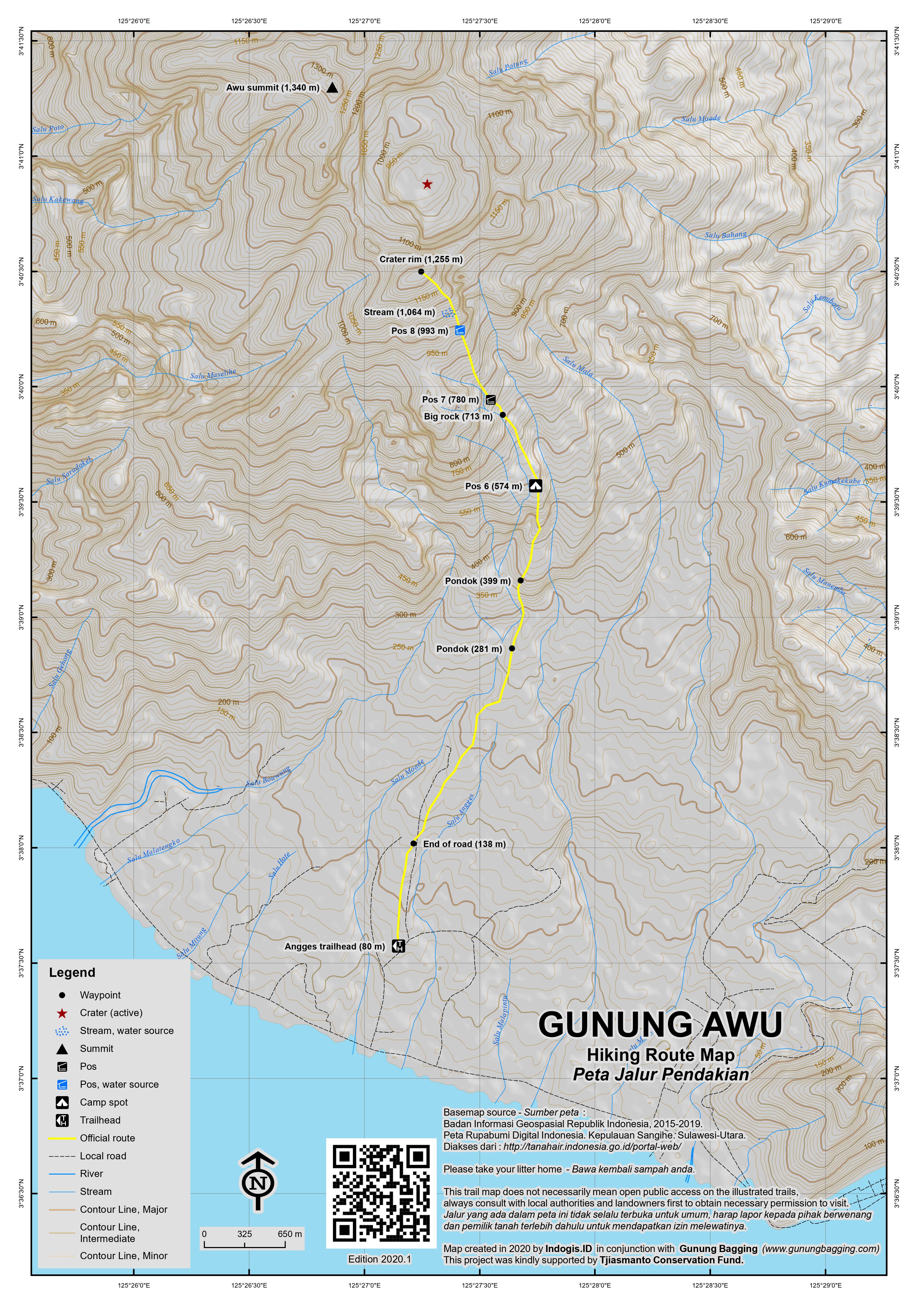
The usual trailhead at Kampung Angges is just 10 kilometres or so from the main town of Tahuna and at less than 100 metres above sea level. After reaching the end of the road (138m), the pleasant trail leads up through coconut plantations, via several huts suitable for taking a rest, and several areas with Pos signs. A particularly nice hut is at 399m just after a steep section of trail. A little further along you will notice what appears to be a volcanology sensor near Pos 6 (574m) which is reached in about 2 hours in total from the start. It is clear that the volcano is climbed fairly often by local hiking enthusiasts but there is very little litter despite people camping here. There are a few leeches but they seem to be a lazy variety that can be pulled off incredibly easily. Not much further on from Pos 6 the forest clears and there are great views back down to Tahuna bay and the southern side of the island. The trail follows a ridge with medium height vegetation – and one large rock you need to climb over (713m) – and the views remain generally good from this point on.
A few sections of the trail require minor scrambling and one part especially is simply a steep – potentially slippery – rockface next to a water pool. Beyond the little rockface is Pos 8 (993m). After this the trail gets steeper and the views more panoramic (including the airport to the east) as you weave your way up to the crater rim (1,255m). This spot is labelled on the Bakosurtanal map as ‘Bentihu Makaampo’ with an elevation of 1,171m which seems an underestimate. In good weather the rim is a wonderful place to sit and admire the lava dome and steep cliff walls.
Unfortunately the highest point of the rim is on the other side (just over one kilometre away) and is not easily accessible from this approach. Heading anticlockwise you would soon find yourself on steep cliff-faces and heading clockwise could well land you in dangerous terrain. It is alleged that hikers have managed to climb round once or twice, but you would really need to camp up here for a night in order to have a proper attempt at it.
According to our guide, a trail leads straight up to the highest peak from Desa Kendahe, but very little seems to be known about this approach at present and it is definitely not the preferred route – perhaps because the best views are to be found on the Angges side.
It should have taken you about 4 hours to reach the rim and it is recommended to allow 2.5 – 3.5 for the descent. There are plenty of angkots/bemos available down at the main road in Angges which will take you back into Tahuna town.
Bagging information provided by Dan Quinn (March 2013)
Trail Map
For a high quality PDF version of this and other trail maps, please download from our Trail Maps page.
Practicalities
- Getting there: Sangihe has an airport at Naha, about 40 minutes drive from the main town and port of Tahuna. There are flights to/from Manado about 3 times a week. Alternatively the fastest ferry takes about 6 hours from Manado to Tahuna.
- Guides and GPS Tracks: Want a PDF version for your phone? Looking for a guide? Need GPS tracks and waypoints? Gunung Awu information pack can be downloaded here.
- Trip planning assistance: Would you like Gunung Bagging to personally help you in arranging your whole trip? Please contact us here.
- Permits: Not required but take a photocopy of your passport photo page just incase.
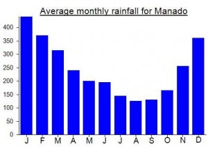
- Water sources: Should be available on the higher slopes, especially at Pos 8, and especially during the rainy season.
Local Average Monthly Rainfall (mm):
Location
Click on the blue arrow ![]() (top right) to see your current location on the map
(top right) to see your current location on the map
https://en.tempo.co/read/1590930/geological-agency-warns-of-mount-awu-eruption-in-sangihe-islands
Awu raised to LEVEL 3.
https://tekno.tempo.co/read/1538637/paling-mematikan-keempat-gunung-awu-naik-status-jadi-waspada
No surprise here at all. Unfinished business. The other one that clearly resembles this (and Kelud in East Java a few years ago pre-eruption) with its lava dome is Gunung Ibu, Halmahera, which is even more active.
It happens so often in Indonesia…. You ask about getting to the highest point, the ‘puncak tertinggi’ or ‘puncak sejati’ and what your guides think is the ‘peak’ is not the actual summit. Local guide Nirwan and his friend met us in the Hotel Nasional restaurant and arranged for their friend Tommy from Kampung Angges to take us up to the volcano the following day. I asked about the true peak in as many ways as I could. Yes, you can do it. 4 hours, no problem. It didn’t quite turn out that way but we had a jolly good hike nonetheless and despite the grey weather. Indeed, the high grey clouds allowed good views and kept the heat down for us. Perhaps I’ll be back to try the mysterious route from Kendahe.
The Marina Coffeehouse is the place to go for food and beer. Just 2 minutes from Hotel Nasional. However I must confess to being close to the edge of madness with all the Hello Mister phrases being shouted at my back or from across the street. I think I had over 100 in under 5 minutes!
Views of Awu from the road over to the airport, and from the airport itself, are particularly fine.