
Facts
- Elevation: 2,151 m (7,057 ft)
- Prominence: 905 m
- Peak category:
 Spesial
 - Province:
 Bali
Bali - Coordinates: -8.2803, 115.4297
- Rating:

 (2 votes) Add your rating
 Loading...
Photos
")
")
")
")
")
")
")
")
")
")
")
")
")
")
")
")
")
")
")
")
")
")
")
")
")
")
")
")
")
")
")
")
")
")
")
")
")
")
")
")
")
")
")
")
 Courtesy TropenMuseum Archives")
 Courtesy TropenMuseum Archives")
 Courtesy TropenMuseum Archives")
 Courtesy TropenMuseum Archives")
 Courtesy TropenMuseum Archives")
 Courtesy TropenMuseum Archives")
")
")
")
")
")
")
")
")
")
")
")
")
")
")
Bagging It!
If hiking up Gunung Batur behind hundreds of others doesn’t sound pleasant, or if you are hungry for another hike in the area, then nearby Gunung Abang is a brilliant choice. It is actually the highest point of the double caldera, and has a prominence of around 905m, but it’s pretty straightforward and takes around the same time as the Batur trek.
Unlike Batur, you will not meet many other hikers on Abang. You can enjoy the birdlife in the forest and spectacular views down to the lake and over the Gunung Batur and beyond to Batukaru.
The registration point (1,330m) is at a road junction in Suter several kilometres east of Kintamani. Rp100,000 for foreigners or Rp5,000 for Indonesians. If you have a guide or are with others then you could hike at night in time for sunrise at the summit. If you are alone it is much better to hike at first light so that you don’t get lost, but only attempt this alone if you have a GPS, torch and are confident and experienced.
From the registration post, continue either on foot (25 minutes) or by bike or car (5-10 minutes) to the trailhead. The road deteriorates and you may want to leave your car at the temple halfway between the registration post and the trailhead (1,367m). Pos 1 is Pura Peyawat (1,575m) – a small shrine with a collection of temple ornaments on a very narrow ride with brilliant views down to the lake. Pos 2 is Pura Andong (1,808m) – a larger set of temples in a beautiful forest environment. Before reaching Pos 2 you should be able to see Gunung Agung to the right (south-east) through the trees – it’s only about 10 kilometres away. Pos 3 is the actual summit itself and this temple area is known as Puncak Tuluk Blu.
In clear weather you can see as far as Gunung Raung in East Java in the west and Gunung Rinjani in Lombok in the east.
It takes most people about 2 hours to reach the peak from the trailhead and about 1.5 hours to descend. No water is available on the trail.
Trail Map
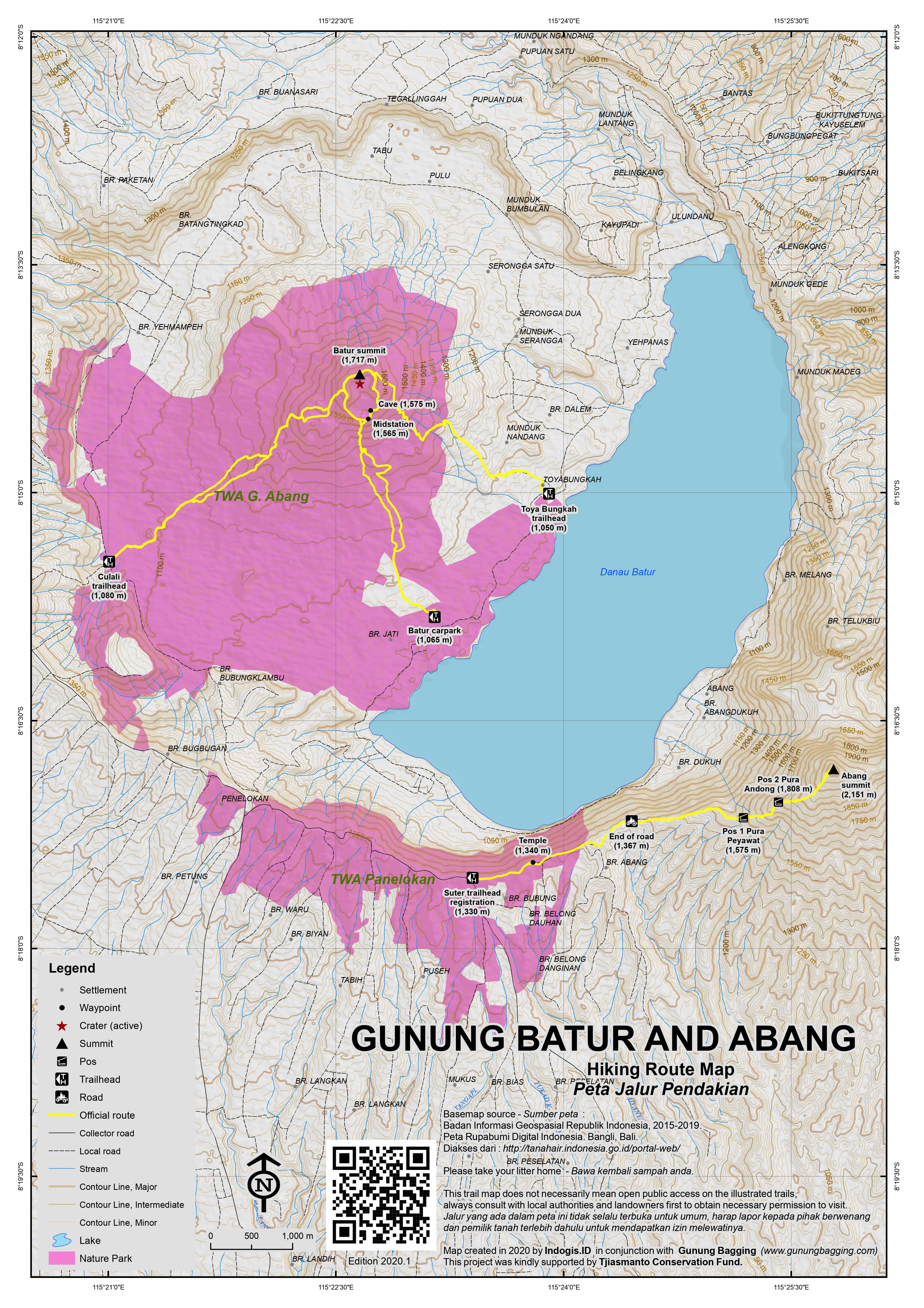 For a high quality PDF version of this and other trail maps, please download from our Trail Maps page.
Practicalities
- Getting there:
- Permits:
- Water sources:
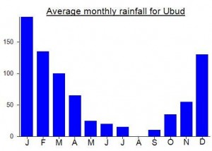
Local Average Monthly Rainfall (mm):
Location
Click on the blue arrow ![]() (top right) to see your current location on the map
(top right) to see your current location on the map