
Facts
- Elevation: 1,184 m (3,885 ft)
- Prominence: 1,184 m
- Ribu category:
 Kurang Tinggi
 - Region:
 Papua Barat (West Papua)
 - Coordinates: -0.8576, 130.6240
- Rating:
 (Bagged it? Be the first to rate it)
 Loading...
 - Other names: Peak may be called Kalaikut. Gunung Yakut on the Bakosurtanal map.
- World Ribus ID: 80067
Bagging It!
This Ribu is the highest point of Batanta island which lies off the north coast of mainland West Papua. Much of the island is a nature reserve and is quite difficult to reach, taking 3 days by boat from Sorong. The highest peak on the island is listed on the Bakosurtanal map as being Gunung Yakut with a height of 1,162m.
Local Accommodation
Practicalities
- Getting there: Boat from Sorong
- Permits: Unknown
- Water sources: Unknown
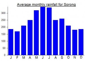
Local Average Monthly Rainfall (mm):
Location
Click on the blue arrow ![]() (top right) to see your current location on the map
(top right) to see your current location on the map