
Facts
- Elevation: 2,877 m (9,439 ft)
- Prominence: 1,723 m
- Ribu category:
 Tinggi Sedang
 - Province:
 Sumatera Barat (West Sumatra)
 - Coordinates: -0.3900, 100.3308
- Rating:


 (7 votes) Add your rating
 Loading...
 - Eruptions: Tandikat 1889, 1914, 1924
- World Ribus ID: 69054
Photos


Bagging It!
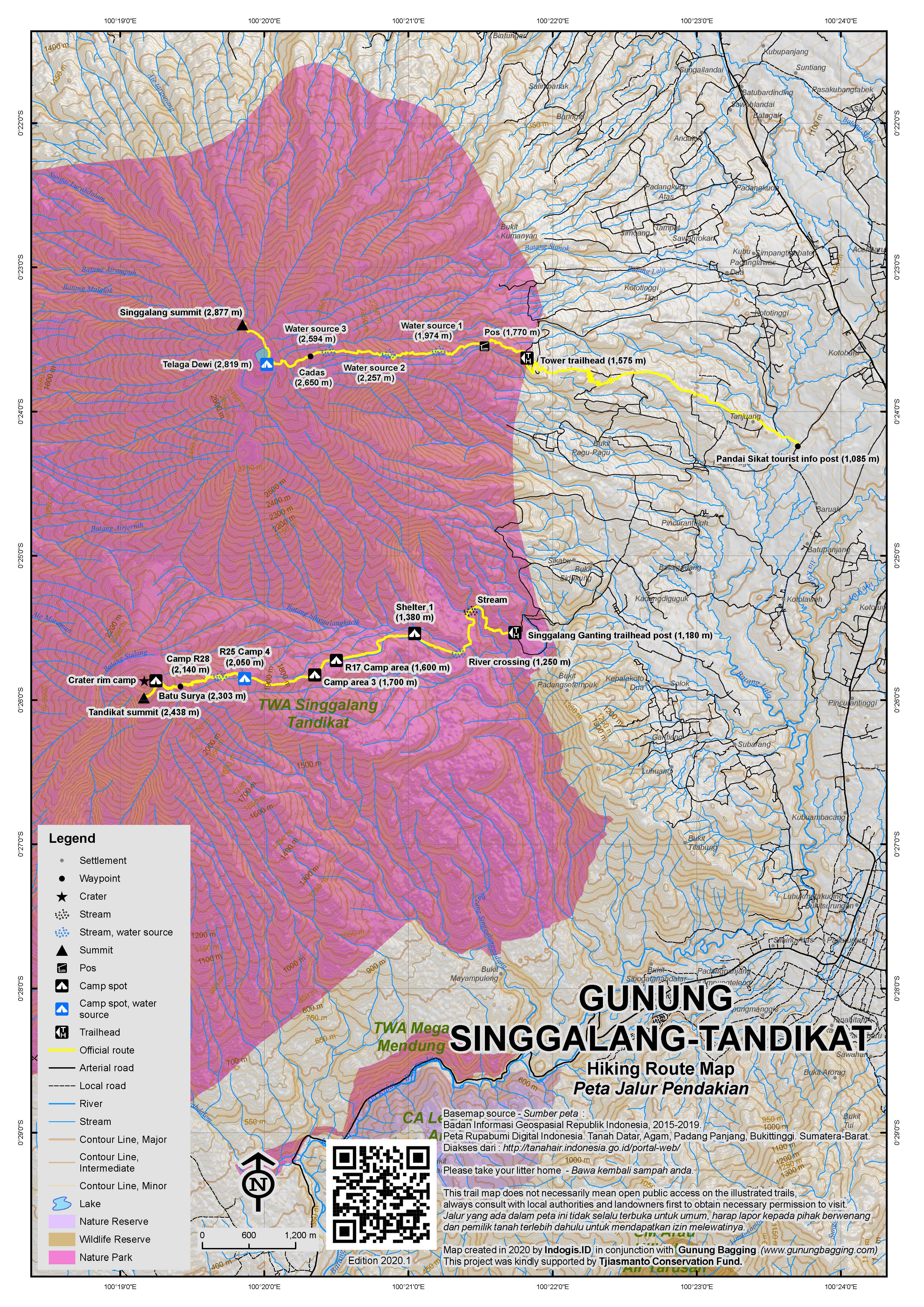
This dormant peak is close to the pleasant tourist town of Bukittinggi and the huge Lake Maninjau. Along with neighbouring Gunung Marapi, it dominates the landscape south of the town. Singgalang is a twin volcano with the lower yet volcanically active Gunung Tandikat (2,438 m) and could be considered as Sumatra’s version of Gede-Pangrango. The mountain can be climbed from several places: Pakan Sinayan, Koto Tuo, Balingka and Pandai Sikat. Although approaches from the west supposedly offer views of nearby Lake Maninjau, the eastern approach from Pandai Sikat is by far the most popular and is just 15 minutes by public transport from Bukittinggi. Pandai Sikat itself is famous weaving and woodcarving village currently illustrated on the 5,000 Rupiah banknote. Unlike for neighbouring Mount Marapi, finding a guide in Bukittinggi is remarkably difficult – far fewer locals have climbed this mountain and barely any tourists trek to the top. In any case, the agents in Bukittinggi charge a bit more than is reasonable – the money then gets split between several people. The best thing to do is head to Pandai Sikat where there is new tourist information kiosk (1,085m).
From Kotobaru on the main road heading south of Bukittinggi, follow the sign to Pandai Sikat and continue along the narrowing road and stop in Pandai Sikat opposite the beautiful and private traditional Minangkabau house with a lilly pond in front. On the opposite side of the road from the house is the small tourist information kiosk where you ask for help finding a guide. The road towards the starting point goes past the house and up the hillside towards several television transmitter masts. Walk up the road for about 5 minutes to the ojek post and take an ojek up to the starting point to avoid around 500m unnecessary elevation gain. You may be asked to stop at an information and registration post about one third of the way up the road and sign a guest book and pay Rp 10,000 to climb the mountain. The road gets rough but a ojek can get as far as the final TV mast at 1,575m. It takes 4-5 hours to reach the summit and 3 hours to descend the same way.
The trail itself leads from the end of the masts road along the right side of a wooden hut, past another, newer building before leading into tall and thick grass vegetation. The trail is a little hard to follow in a couple of places through the grass, so you need to a guide or to use our GPS tracks. A bundle of 4 or 5 black electricity cables follows the trail all the way to military and police communications towers on the summit of the peak that were erected around 2003, so if in doubt follow the cables. This first section of the trek is by far the most unpleasant – especially for tall people – several times you have to crawl under the the tall grass that has fallen over the path obstructing your headroom. There are also some leeches in this section so take some gloves and wear long trousers!
Thankfully the trail soon opens out into more regular tropical forest, with the sound of streams to your left. Water is not a problem on the hike as there are three posts on the way up near water sources and a lake near the summit. The first area used for camping is at 1,770m but the water sources (Mata Air 1, 2 & 3) are at approximately 1,974m, 2,257m and 2,594m respectively. At 2,650m the trail opens out onto steep rock (‘Cadas’) and if you are lucky with the weather you should be able to see Marapi on the other side of the Agam valley.
Near the top of the rock section at 2,697m is a plaque dedicated to two students from Padang who went hiking here in 1988 and never returned. Shortly after this monument, the path dips slightly – still following the black cables – through some pleasant mossy upper montane forest. The beautiful lake, Telaga Dewi (Lake of the Goddess, 2,819m) is just beyond the muddy trail through the forest and it is a beautiful, tranquil spot and unusually free of litter. Locals like to camp here on Saturday nights but at any other time of the week you will probably be alone. The lake itself is where the crater of the volcano once was, thousands of years ago.
At the other side of the lake you should be able to see another transmitter mast at the highest point of the mountain. To reach this, follow the black cables along the side of the lake and then through very muddy and sometimes slippery forest. After 30 minutes you will be at the edge of the transmitter compound which is the highest point of Singgalang. This shabby and litter strewn area could not be in starker contrast with the natural beauty of the lake. One can image that Singgalang was a more rewarding summit before the authorities decided to erect the transmitter. However, in clear weather, you should be able to see Gunung Marapi on the other side of the valley.
Gunung Tandikat/Tandikek:
There is no proper trail between Singgalang and Tandikat at present (2018). However, for those staying in the area for a while and keen for another serious hike, the separate trail up Gunung Tandikat is incredibly worthwhile as the crater is several hundred meters wide and offers great views. The basecamp (1,180m) is in Singgalang Ganting, less than 30 minutes by car or motorbike from Padang Panjang via Simpang Tawalib and Jalan Lubuk Mata Kucing. You will probably not be alone on the mountain during weekends (except possibly during Ramadan) but local mystical beliefs, tales of tigers and sun bears, and the lure of the more popular Marapi, currently keep numbers down at a low enough level that there is very little litter on the trail.
The pleasant trail is marked with regular, numbered yellow signs all starting with the letter R (R=’rambu’ (‘sign’)?) but you may need local help for the first 30 minutes or so, as the path gains little elevation at all, and follows a cement watercourse with a couple of minor junctions. Take care on this cement in wet conditions. You will need to cross a couple of minor streams here. Sign R04 (1,200m) is a about halfway between the trailhead and a proper narrow river crossing with boulders (1,250m). You may need to either take your shoes off or risk allowing them to get wet here.
After the river crossing, the trail enters denser vegetation and the next major landmark is ‘Shelter 1’ (1,380m), which offers no structural shelter but does have enough flat space for a couple of tents. The next decent spot for pitching a tent or two is R17 (approximately 1,600m) and a third one at just beyond 1,700m. However, if you can keep going to R25 (approximately 2,050m) then this is perhaps the best option before the crater rim as you are very close to a water source. It shouldn’t have taken fit hikers more than 3 and a half hours to reach R25 (also known as Camp 4 on one sign) from the trailhead. There are no views here as it is dense forest, but there is a lot of birdlife in the trees and you may also hear siamangs nearby.
Beyond Camp R25, the trail drops down to the right, crosses a river, then R27 sign, then another river (2,120m) before another potential camp spot at R28 (2,140m). Not long after is R29 (2,200m). The next major landmark is R32 (2,300m) where you can see the shapely forest-clad peak of Gunung Singgalang to the right. A little way beyond R32 is Batu Surya (‘solar rock’, 2,303m), a large boulder where hikers often have their photos taken. This part of the trail is allegedly where Sumatran tigers have been seen in the past, and also supposedly where tapirs live (a food source for the tigers, perhaps, given that locals say there are few, if any, wild pigs (‘babi hutan’) on this mountain.
After Batu Surya, the trail drops down a few metres, and crosses a muddy, boggy col before ascending once more to the crater rim (2,400m). Suddenly you will find yourself with an impressive panorama open in front of you and even a spot near the rim large enough for a small tent. To the right is Singgalang, the ‘mother mountain’ of Tandikat. The crater cliffs are very steep and must drop down around 100 metres to the sandy crater floor. You should be able to see various names written by local hikers using rocks in the crater. For those particularly interested, there is still some fumarole activity down there and it is possible to descend into the crater if you follow the rim to the right for a few minutes. Allow 30 minutes to get down into the crater and perhaps 45 to get back up again, but don’t consider doing this unless you have someone who has definitely been down there before!
For those wishing to reach the true summit, it lies just 10 or 15 minutes or so to the left (300 metres round the rim, clockwise). The path there is a little overgrown and occasionally passes dangerously close to the crater rim edge but is clearly signposted and definitely worth visiting. From the true peak (2,438m), the views northwest to Gunung Talakmau and north to Singgalang are very pleasant, and much better than from the usual spot that hikers finish. Do be aware that one sign in 2018 suggested we were at the summit a good 5 minutes before we reached the true summit. If in doubt, keep on going a little further!
From Camp R25 to the crater should take about 90 minutes or less, so approximately 5 hours in total from the trailhead (not including breaks). Given that the trail is not horribly steep like many others in Indonesia, most hikers should be able to be back down at the trailhead in just over 4 hours.
Puncak Lawang and Danau Maninjau:
For those staying down on the relaxing shores of nearby Lake Maninjau (e.g. at Bagoes Cafe and Homestay), a stroll up to the popular viewpoint top of Puncak Lawang (1,246m) is a worthwhile half-day (or less) out. Whilst Gunung Singgalang can only be seen from parking area rather than the actual top, and although Puncak Lawang is nowhere near the highest point of the huge Maninjau caldera rim (which is at least 1700m in elevation, likely to be densely-forested, and located to the north-west of the lake), the view from Lawang top over Lake Maninjau is very impressive. It’s a shame the authorities are constructing a huge building there at the time of writing, but you can always just ignore it and face the lake instead! You can actually hike up here from the simple guesthouses on the shores of the lake and back down again (total likely to be 5-6 hours) or simply get an ojek from the main Maninjau T-junction for around Rp100,000 return (in 2018) taking about 35 minutes each way. If you take an ojek, the entrance fee is Rp10,000 per person (2018) and in less than 5 minutes you will be at Puncak Lawang, presumably with numerous local tourists.
Bagging information by Daniel Quinn (2009, minor updates in 2018) and Andy Dean (2011)
Trail Map
For a high quality PDF version of this and other trail maps, please download from our Trail Maps page.
Practicalities
- Getting there: The nearest city is Bukittinggi, the nearest airport is Padang, which is about 2 hours from the mountain.
- Guides and GPS Tracks: Want a PDF version for your phone? Looking for a guide? Need GPS tracks and waypoints? Gunung Singgalang information pack can be downloaded here.
- Trip planning assistance: Would you like Gunung Bagging to personally help you in arranging your whole trip? Please contact us here.
- Permits: Pay Rp20,000 at the trailhead (2017) – and take a photocopy of your passport photo page just incase. For Tandikat the 2018 price is Rp10,000 per hiker and the same again if you want to leave your bike there.
- Water sources: On the Pandai Sikat route to Singgalang, available at 1,974m, 2,257m and 2,594m. On the main route to Tandikat, available at the river at 1,250m, just beyond Camp4/R25 at 2,050m, and at 2,120m.
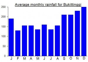
Local Average Monthly Rainfall (mm):
Location
Click on the blue arrow ![]() (top right) to see your current location on the map
(top right) to see your current location on the map
thank for gpx file, iam local boy, just wonder when you climb singgalang mountain ??
Thank you for the chapters
Climbed Gunung Tandikat at the weekend with my good friend Rijal, whose family is from Sikadungdung village near Pandang Panjang.
You can get a Grab Car from Padang Airport to Padang Panjang for under RP200,000 (90 minutes), but be aware that getting one back is, as usual, much tougher as there are few drivers around. My driver asked me if I was from Uruguay originally but other than that and the torrential rain the journey was uneventful. The forecast looked pretty bad for Saturday but dry for Sunday, so I suggested we just do it as a dayhike on the Sunday, setting off really early. Anyway, Rijal wanted to head off and camp on the Saturday, plus there were others coming from Bukittinggi to join us, so despite still recovering from flu I agreed. Up at Sikadungdung (1285m), a farm village with carrot fields, the view straight up to SInggalang and Tandikat, plus over the valley to Marapi is great. Lovely temperature too.
We waited for the Bukittinggi boys to arrive. Waited and waited. They finally arrived at just before 2pm. How is it I can get there from Jakarta by just after 10am, yet a group from just an hour up the road cannot roll in until after lunch? Remarkable! As it turned out, they ended up climbing Singgalang (possible from Sikadungdung), so it was just me, Rijal, and a mate of his from the village to carry my bag (still ill!). We cut down through the fields near the minor Bukit Api and in half an hour were at the registration post. Great to see this is now getting more popular – a recent Grab driver told me he had wanted to climb it but was scared by the mystical stuff attached to it. Whereas Marapi is covered in litter and tents every weekend now, this is still a proper escape from civilization (assuming the other group or groups who may be on the mountain with you don’t decide to pitch their tents next to yours and make inane noise until well past midnight!) Yes, this did happen…. but I was too exhausted to get out of my tent and tell them to turn the volume down! Are these folk, friendly though they often are, actually more interested in getting away from their parents and villages and worlds of rules than hiking itself? I think the answer is pretty obvious!
The forecast proved correct (YR.NO – Norwegian and usually reliable) and Saturday saw a lot of rain and a fair bit of wind too. Luckily Sunday morning was calm and clear and we set off up to the summit. Stunning views at the rim, some mad hikers taking selfies down in the crater, Edelweiss growing on the edge of the cliffs, and very little litter.
Back in Padang Panjang I had no luck with Grab drivers so got a seat in a ‘travel’ (shared car) for Rp70,000 to the airport. A very worthwhile weekend trip for those so inclined.
Finally got around to visiting Lake Maninjau and Puncak Lawang last weekend. Some lovely views from the plane itself of the Banten hills, Rajabasa, Dempo, Kaba and Daun. From Padang Airport I couldn’t find a Grab ojek willing to take me all the way to Maninjau so a car it was for Rp400,000. We took the coast road via Pariaman and Tiku which meant a chance to see the western shores of the lake too. Took about 2hr 20min to reach Bagoes Bay, which seemed pretty full with foreign tourists and although only providing basic accommodation has lots of information and a very pleasant simple restaurant right on the edge of the lake.
It was surprisingly windy at times, so I had to move tables to avoid my pen and paper being blown into the water. According to a local chap at the cafe, the wind brings the sulphur up from the bottom of the lake (this is of course a huge ancient caldera with some ongoing activity e.g hot springs) and the sulphur in turn brings the fish closer to the surface making them easier to catch.
The lake is at an elevation of just under 500m and Puncak Lawang in around 1250m. I was lazy and decided to take an ojek there for late afternoon – plenty available at the ojek post at the junction before/after the steep windy road to Bukittingi with 44 Keloks (44 turns). Great view over the lake as expected, but the construction work really detracts from the atmosphere… quite why the authorities want to ‘urbanise’ hill-top viewpoints when it is their very lack of buildings and all the sorts of things you get in towns and cities which is of course the main attraction in the first place! Presumably their next plan will be some more huge Instagram selfie signs to remind people where they are and/or save them from having to actually tell people or remember where they are in the picture.
Sunsets are generally excellent down at the lake and beer Bintang is most certainly available! Seat in regular shared cars to Bukittinggi Rp25,000 and takes just over an hour.
Hello
Does anyone have a good guide to recommend for these 3 mountains over 2-3 days from 14-16 Feb 2018?
Mount Singgalang
Mount Marapi
Mount Sago
Thank you.
Regards
Bernard
hello.
I will go there on 15 – 19 feb 2018. I’m looking for a partner, but only hike Singgalang and Marapi. If you had the same idea, maybe we can team up. I will be arrive at Koto Baru at 16th feb evening.
Hi Yanto, 16 Feb would be my last day at Bukittinggi 🙁
The following comment should be prefaced with a short note to say that there is little information about SInggalang or Tandikat below! It is a description of an all-too-common experience that many travellers to/in Indonesia face when simply trying to get from one place to another to hike, or dive or whatever… Its main cause is utter ineptitude and unprofessionalism…. and its main effect, even on the naturally enthusiastic… is to make them vow ‘never again’ or ask themselves ‘why I am I doing it when it is such an unpleasant experience?’
After cancelling my trip to Bali last weekend due to the high likelihood of an Agung euption (still not yet occurred, thankfully for the locals), I was hoping for better luck this weekend – a trip to Danau Maninjau and one night camping on Gunung Tandikat – Singgalang’s lower neighbour.
Sadly, I ended up cancelling this one too – mainly due to Lion Air, an airline I often promise myself never to use ever again but often do simply because of the timing of flights with other airlines being inconvenient for weekend trips after work. I was originally booked on the 17.55 from Jakarta due to arrive in Padang at 19.40 – therefore enough time to get to Maninjau ( a 3 hour journey) by around 11pm. A long day but as long as I cound arrive by midnight or thereabouts it woud be doable.
Naturally, Lionair cancelled this flight and stuck me on another, leaving an hour later at 1855 (or supposedly leaving at that time). At least they had the manners to notify me about this 2 days in advance.
Anyway, things got off to a bad start before even arriving at the airport – there is work going on on the Jakarta airport toll road at the moment meaning even worse delays than normal. Took 2 hours to travel about 25 kilometres – a good half an hour of this was travelling at slower than walking speed but on a toll road where you actually have to pay for the ‘pleasure;. Few other countries would have the arrogance to think this state of affairs is anything other than disgraceful. If it is faster to walk then you should have no right to demand any money from anyone who uses your ‘service’.
At the same time, sat in the car, I was reading an article in the Jakarta Post about Indonesia’s Tourism Minister, Arief Yahya, visiting Thailand to try to understand why Thailand is so much more successful when it comes to tourism. http://www.thejakartapost.com/travel/2017/09/29/tourism-minister-wants-to-learn-from-thailand-tourism-.html
If it isn’t perfectly obvious why Thailand is doing much better than Indonesia (even though it has far, far less places to offer) then Mr Yahya needs to book a domestic Lion Air flight departing Soekarno Hatta on a Friday night and see what happens. It ought to be completely obvious to anyone. As is customary, the occasional ‘little sultan’ barged his way through the traffic jam on the toll with his flashing light and toytown buzzers – some of these primitive government ministers and provincial bureaucrats seem to think they are better than the rest of humanity.
Finally checked in and looked at the information screens – all Lion Air flights listed as ‘sesuai jadwal ‘ -on schedule, as is usually the case on the screens. Alas, the reality is usually very, very different – the screens seem to be there merely to create the facade of professionalism and competence.
I searched for a beer – but none are to be found in Terminal 1 -something else Mr Yahya might want to look at….. trying to force all visitors to Indonesia to follow one particular religion’s restrictions on what most humans regard as pretty normal activity does not do a lot for the reputation of the country overseas. If you don’t like beer then don’t drink it – but let other, more worldly, people decide for themselves. Could be beneficial when it comes to soothing the frayed nerves of Lion Air passengers who have spent 2 hours getting to the airport before even finding out how delayed their flight actually is.
The information desk staff had little information as usual – playing on their phones, but smiling and saying ‘belum datang’ (plane not yet arrived) when anyone asked for information or ‘belum update’ and giggling when I asked why the information screen said all flights were on schedule yet in reality very few were. As soon as I started complaining, Indonesians started complaining too. Normally, most Indonesians will accept anything, put up with any level of service, nomatter how low. And this is exactly why the service never improves… it doesn’t have to if most customers are willing to be treated so poorly. Tip for Indonesian customers… start complaining a bit more and you might see an improvement! Just saying ‘oh yes, that’s just how it is in Jakarta/Soekarno Hatta/Indonesia/etc’ is no good for you and no good for your children or children’s children. Have some self-respect.
Sadly, if you want any information about a Lion AIr flight in Indonesia, there is not much point asking Lion Air staff in Indonesia. You are better off using an international website such as Radar Box, which will actually provide you with some information that may be accurate. Again, much like the information screens, the staff themselves seem to be there mostly to provide a facade of professionalism rather than to actually offer any useful information.
The flight I was looking for was listed on the (mis?)information screen as ‘on schedule’ (just like all the others – as if Lion Air has a 100% punctuality rate) but according to Radar Box the aircraft was still in the air in the Banyuwangi area of far East Java at the scheduled time of departure (which was already an hour after my original booked flight). This meant chances of us taking off before 2030 (over 90 min extra delay) were minimal.
Having been up since 5am, been to work, dealt with the hideous toll road traffic for two hours, and then now being confronted with the thought of not arriving in Padang until 2230 and Maninjau until 0130 at the earliest and I lost my temper and stormed down to ‘customer service’ where I was given the same smiley nonsense as is expected… all smiles and no useful information or genuine apology. I demanded my luggage be returned to me… a weekend in Jakarta would be better than continuing with this rubbish and getting very little sleep at all before the hike.
Of course, the first taxi driver at the airport didn’t do what he should (presumably legally) do and use the meter, but rather asked for Rp300,000. These pests should be eradicated – they are often the first person a new visitor to Indonesia encounters…. what a great way to colour one’s perceptions of a nation before even leaving the airport!
So I got in an Express which are usually pretty decent and in this case were – perhaps the ‘highlight’ of my trip to and from Soekarno Hatta on a Friday night. The traffic was still horrific, even from the airport into the city, and it took 2 hours to get home. What a great night out! Time to unpack my backpack and then go to bed.
So, I had wasted over a million rupiah on the flights, and several hundred more on taxis and a hotel booking at Maninjau – for nothing. At home, I did wonder if I had been too hasty in deciding to abort the trip, but when I looked again at Radar Box (and similar websites) I couldn’t believe it. The flight had not left for Padang until 22:11. It had only just taken off and was still enroute and would not be landing until just before midnight! I had made the right choice. Sometimes a weekend away is just not worth the mountain of effort (the mountain hike is often the easiest part!)
So, to sum up, flight was due to land in Padang at 1940 on original flight, but this flight was cancelled and I was put on the next one. I then cancelled this due to horrific experiences at Terminal 1 and no sign of aircraft until after 8pm. In the end, the flight landed at around midnight in Padang. My last Lionair flight on a Friday night was also 4 hours late (to Balikpapan). It almost seems like a Lion Air tradition. Well done, management of Lion Air! Real professionals! What a culture! Over 4 hours later than my original scheduled arrival time. What a wonderful service you provide to those who work hard and spend their earnings on your tickets. Worth every penny (look up the word ‘sarcasm’).
So, advice for the Tourism Minister. Two options…. first of all you could try this radical idea….. look at what you’re doing at the moment with Indonesian tourism and just do the complete opposite (it may actually make for a better experience). Secondly look up the words ‘competent’, ‘informative’ and ‘punctual’ in a dictionary and see if you recognise the importance of what they mean and how they might make for a pleasant trip to/in this country. PS This may seem hard to believe, but an information screen means very little if the information on it is wrong.
And advice for hikers and other travellers…. book with Lion AIr if you like the idea of a 4 hour delay and incorrect information at every turn. Otherwise, try Citilink, Sriwijaya, etc…. they may be late, but not usually this bad. If going to/from Jakarta, try to fly to/from Halim rather than Soekarno Hatta unless you are travelling between 1am and 5am, which are the only hours in a day when you might experience a level of traffic and speed that could be regarded as functioning normally.
For my part, it is one of those experiences that makes me wonder whether I need to recalibrate my life… whether there is a more enjoyable task to get on with than the ‘gunung bagging’ task, which quite commonly ends up with experiences such as that described above, or whether I just need a rest this weekend before trying again. Trying to do these trips at weekends after work makes it really difficult to avoid problems given the level of unprofessionalism provided by many Indonesian airlines and the toll road operators for what should be a simple trip to and from the airport. Naturally I won’t get my money back, as ethics means little in business, but I have some time to think.
And guess what? I’m booked on Lion Air again next weekend (due to no alternative options being available).
UPDATE: Out of interest, I searched for how delayed my return flight from Padang would have been. The information was rather disturbing. Was due to fly 2020, land Jakarta 2210 Sunday night. The reality was an 0333 departure Monday morning, arriving in Jakarta at 0457. A seven hour delay. Do you need any more proof of why Lion Air are best avoided?
hello dan.. when you planning to climb singgalang? i want to climb singgalang and marapi. and its hard to find package for that.. i’m looking for dayhike for both mountains.. – Roy
I’ll be hiking Tandikat (not Singgalang but near it) in Feb or March. No plans to hike Marapi again soon. Guides for Marapi easy to find and lots of locals hking it anyway. For Singgalang, best ask in the local villages if you can speak basic Indonesian.
I climbed Gunung Singgalang on April 10th 2017.
I left Bukittinggi at 3am. It was very hard to find a transport. I walked on the main road for 15min and finally find an ojek. We stopped at the posko. I paid 20.000 and registered. I left some stuff at the posko. And I started to climb at 6am.
The trail is slippery, especially after rainy days. The start through tall and thick grass is exhausting. Then you follow the trail in a nice forest. Unfortunately a lot of trash. I met some young indonesians. The last part, just before and after the lake are really muddy. I got the shoes all wet. The lake is really nice and worth it. The summit is a little bit disappointing. almost no view and very dirty.
Be careful going down, it’s very slippery, but it can be fun to finish on the butt.
I had the number of my ojek so he was waiting for me at the beginning of the track. No tarred road.
Although the regular trail has lack of naturality due to established all the way electric poles to its summit, it is still have it own charm. I did a ascent from the nearest town of Boto Baru, proceeding to Pandai Sikek vilage from where one have to follow semi-asphalted road up for 4 km. where on the end of it there are several towers. After spending about 3 hours through tall grass and used the muddy very well trodden thus unpleasant trail, eventually I came to the rocky outcrops nearing the summit. From there I took my sunrise pictures,enjoing the good clear weather. Later I discovered the alpine lake Telaga Dewi just below the summit. From summit itself there is not much to do, this spot include a lot of litter left after building the militar towers there. But, on the other hand the good idea is to climb the bigger tower as the spot is mostly obscured by trees. I did it to the tower’s top and was rewarded with a additional panoramic view of Indian Ocean with small islands around Pariaman, to the left it was famous lake Maninjau(it was unusual to see it from this angle) and just behind me when I held on tower’s poles, one could see an active volcano Tandikek, that stands just nearly joined with it’s mother’s cone Singgalang. Unfortunetly, some better views are came with the cables and others towers construction.
One of the hikers I climbed Sago with last weekend knows a lot about this mountain as he lives in Padang Panjang. From there, it is a 4 hour hike to Tandikat peak which is an active crater. You can cross from Tandikat to Singgalang peak but it takes a day to do so! Rizal showed me some photos of pitcher plants (Nepenthes) growing on the mountain – something I hadn’t seen on the regular Pandai Sikat route.
It’s the beautiful lake and forest area near the summit that saves this hike from being one only for summit baggers. The start of the hike requires about 30 sweaty minutes walking up through tall and thick grass, which on 5 or 6 occasions requires you to get down and crawl along the muddy trail. With one or two leaches thrown in, is not an auspicious start to a hike. However, the forest does improve after this and the trail is quite litter free. Following the electricity cables does somewhat ruin the ambiance, but is nice to have a mountain to yourself.
The lake area near the summit is really very nice and reminded us of Scotland, with stunted trees and a good quota of boggy ground. Some great camping areas.
The summit is, quite frankly, a disgrace. First, there is the decision to build a tower on the summit. Second the fact the whoever built it just left all their trash and waste – and the maintenance crews are regularly adding to the trash problem. It also disappoints that other hikers are now also just dumping their trash all over the summit too. It’s best not to linger and go back to the lake to clear you mind, and prepare yourself mentally for the re-run of the tall grass and leaches at the bottom!
Wait, I cannot fathom it being so satrigthofrward.