
Facts
- Elevation: 1,754 m (5,755 ft)
- Prominence: 1,250 m
- Ribu category:
 Kurang Tinggi
 - Province:
 Nusa Tenggara Timur
 - Island: Flores
- Coordinates: -8.6727, 121.8111
- Rating:

 (10 votes) Add your rating
 Loading...
 - World Ribus ID: 69126
Photos


Bagging It!
Keli Lepembusu is a few metres higher than nearby Gunung Kelimutu, whose famous three crater lakes of different colours are one of the main tourist attraction on Flores. You can see Keli Lepembusu from Kelimutu’s so-called “Inspiration Point” where everyone goes to see each of the three coloured Kelimutu lakes. If you look directly north from Inspiration Point, you can see a Telkom communications tower at the end of the long ridge that forms the other side of the valley containing the village of Moni (732m). This is Keli Lepembusu and it is well worth bagging.
Keli Lepembusu is not as interesting as Kelimutu, but it does provide excellent views of the surrounding area, including looking back towards Kelimutu and Moni. It is also the easiest Ribu to bag that we know of anywhere in Indonesia (so far!) because there is a good dirt track along the ridge all the way to the summit. You can bag this summit in less than 2 hours round trip by motorcycle from Moni, and you’ll probably meet some interesting locals along the way. The best option is to go directly to Keli Lepembusu after you have left the masses on Kelimutu, or after a quick breakfast in Moni.
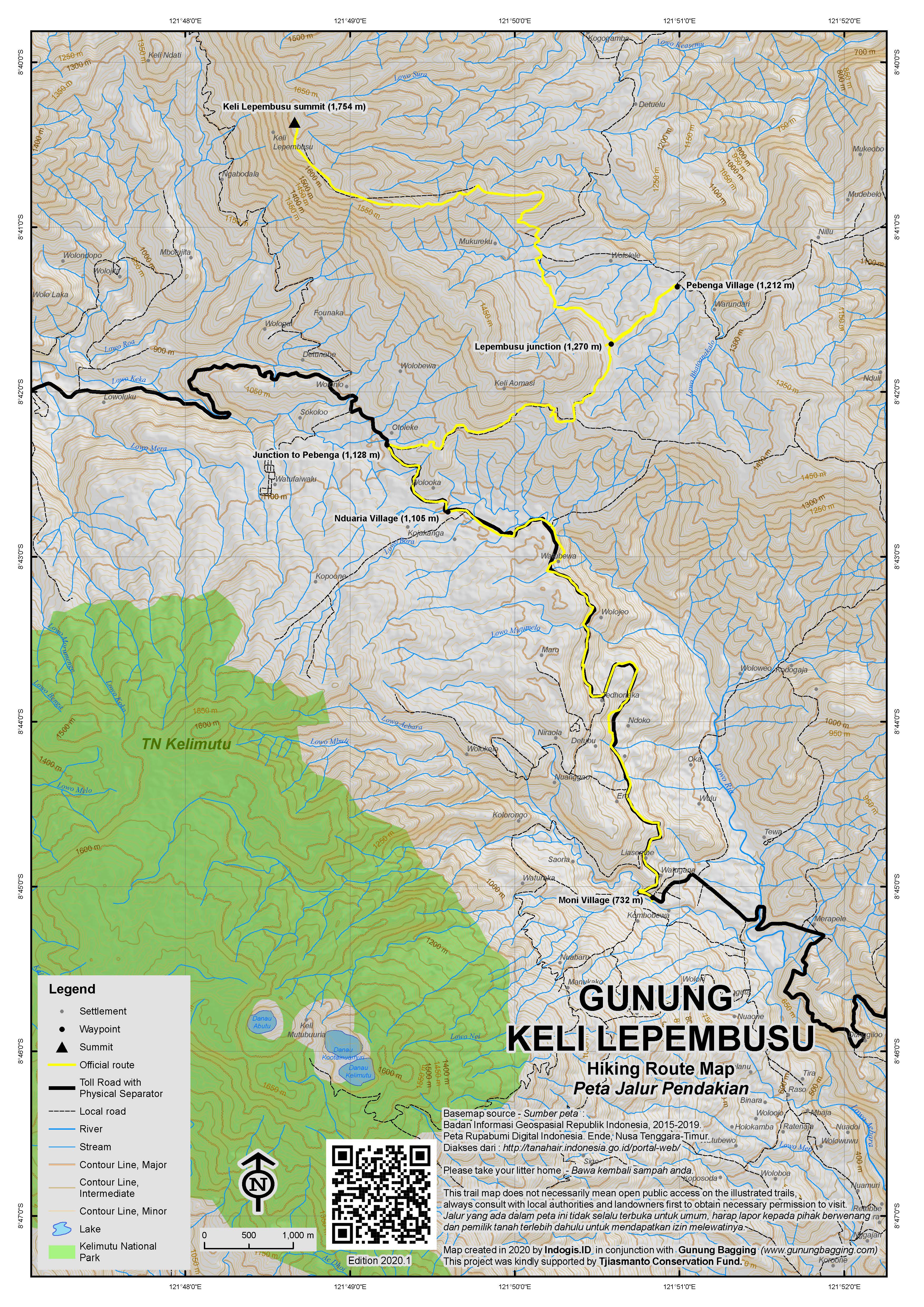
From the starting point at the Telkom sign (1,270m) on the road between Nduaria and Pembenga, simply turn up the road and follow it all the way to the summit. By motorbike, it’s less than 30 minutes from the turning to the summit. You pass through the small village of Mukureku on the way and will no doubt cause some amusement to the locals as to why you are taking a motorbike to the Telkom Tower. At the summit, the Telkom tower is gated, but if it’s locked the friendly (and bemused) guard will open the gate so you can admire the views all around the area.
If you climb the small water tower, you will have reasonable views towards the Kelimutu mountain range, to the south-west the peaks of Ebulobo and Inerie and also the northern coastline of Flores. The guard may even coax you up the huge telecommunications tower itself! If you’re confident enough and the weather is clear you can just about see Rokatenda volcano off the north coast from the first rest space on the tower.
Return the same way. Since ridge walks are something of a novelty in Indonesia, it would be pleasant to walk this hike if you did not want to rent a motorbike. The tower is 7 km from the main road, which should be walkable in 1.5 hours. There are some great views from along the ridge over across the valley towards Kelimutu.
Bagging information by Andy Dean and Daniel Quinn.
Trail Map
For a high quality PDF version of this and other trail maps, please download from our Trail Maps page.
Practicalities
- Getting there: You will most likely be travelling across Flores – From Moni (or the road from Kelimutu National Park), take the main trans-Flores road towards Ende. Approximately 6 or 7 km from Moni you reach the small market along the road at Nduaria. A further 1.5 km along the main road take the right turn on a paved road that takes you up to the ridge – you are heading towards the village of Pebenga on the other side of the ridge. After approximately 3 km you will reach the paved road’s highest point on the ridge and start to drop down the other side. After about 500 m you will see a dirt road on the left with a large concrete Telkom sign – this is the road to the summit. If you need to arrange for a local motorcycle taxi (ojek) then follow the main road for less then a kilometer in the village of Pebenga. Here you can find locals with bikes who are more than happy to take you to the Telkom Tower for around Rp. 50,000 return.
- Guides and GPS Tracks: Want a PDF version for your phone? Looking for a guide? Need GPS tracks and waypoints? Keli Lepembusu pack can be downloaded here.
- Permits: No need for permits.
- Water sources: There are no sources of water on the hike, but then you hardly need it if you are taking a motorbike.
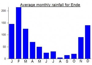
Local Average Monthly Rainfall (mm):
Location
Click on the blue arrow ![]() (top right) to see your current location on the map
(top right) to see your current location on the map
My initial plan for Keli Lepembusu was to catch a bus from Moni up to the junction for Pebenga, then an ojek to Pebenga, followed by a walk up to the Telkom tower. However, the first bus driver who stopped refused to let me on board, claiming to be ‘full’; perhaps only passengers going all the way to Ende are welcome. I then decided to simplify the process and arranged for an ojek direct to Keli Lepembusu and back to Moni for Rp200,000. (Try to get a bike with enough power to carry a passenger up the steep slopes; I was forced to dismount and walk on two uphill sections approaching the Telkom tower.)
The journey takes about an hour each way – 15 minutes up the main road, 10 minutes up the side road to Pebenga, and 35 minutes along the track to the Telkom tower. Contrary to the advice given above, we did not turn left at the first track after the crest of the hill on the road to Pebenga. There is no Telkom sign there now, but rather a warung selling basic goods. The shopkeepers suggested we instead use the supposedly better cement track that goes left from just after the SD (primary school) in Pebenga, passes the Puskesmas (health centre) and continues to Mukuroku village, where there’s a crossroads: keep going up!
Bizarrely, when we got to the Telkom tower the guard could not find the key for the padlock on the gate. Luckily, it was easy to climb over it! (In the unlikely event that guests ever become unwelcome here, you could still bag the peak, as some parts of the grassy perimeter outside the fence are as high as the land inside.)
After an interesting chat with Carlos the guard, I climbed the tower to the first platform, but clouds blocked the view in all directions except down toward Nduaria. Probably we should have come earlier in the morning. From experience on this and previous trips to the Kelimutu area, the clearest skies seem to be between about 07.00 and 09.00.
On the way down we made interesting stops in Mukuroku and Pebenga (spelled Peibenga on some signs) to photograph traditional houses – Pebenga has a whole square of them – and chat with the friendly villagers. We also met three separate bemos packed with returning Christmas shoppers and visitors. (I noticed that bemo passengers also disembark so that the vehicle has enough power to get up the steep section to Mukuroku.)
In Pebenga, a young man called Fitus and an accompanying gang of children persuaded us to go on a 20 minute ‘extreme’ hike down to a waterfall, that he claimed to have discovered while out hunting for mongooses and other creatures. The waterfall, called ‘Muru Tai Kale’ and about 60 meters high, with a deep swimming pool at the bottom, was certainly worth visiting, but the path was indeed very steep, slippery and scrambly, so perhaps not for the average tourist in its present state.
By 13.00 we began what turned into a rain-interrupted, and very soaking, ride back to Moni. Thick clouds and pounding rain set in for the afternoon and made it impossible to do anything except hide out in the hotel.
Just went there this morning. I don’t completely agree here. I hired an ojek from Bintang Guest House in Moni. They wanted Rp300,000 but I got it down to Rp200,000. The dirt track there was longer than I imagined and the ojek man kept shaking his head wondering why we were going there. The guard at the top was indeed nice and even encouraged me to climb the mast, but I was immediately disappointed about the view. You can see nothing from ground level as it is overgrown all around the perimeter fence. From the water tower there is a limited view. Though if you are prepared to climb up the mast ladder, (as the guard enticed me to do) the higher you go the more you could see. But that’s not for anyone who doesn’t like heights and I myself only went up 20 metres. I personally would recommend this only if you are willing to climb a long way up the mast ladder.
This was my 40th Ribu! A bizarre Ribu like no other! Recommended – the guards at the tower are great fun and I’m sure if you take them a packet of kretek cigarettes they would love it!