
Facts
- Elevation: 2,850 m (9,350 ft)
- Prominence: 1,635 m
- Ribu category:
 Tinggi Sedang
 - Province:
 Sumatera Selatan (South Sumatra)
 - Coordinates: -4.2576, 103.3057
- Rating:

 (3 votes) Add your rating
 Loading...
 - World Ribus ID: 69064
Photos


Bagging It!
Volcanic activity was reported in 1989. It’s a huge range and a handful of local groups have conducted expeditions here. It is unclear if any have been to the true summit or not. Please contact us if you can help with detailed info.
Practicalities
- Getting there: By road – Bengkulu is 4 hours away, Palembang is 6 hours away. Or take the daily Wings Air flight to Pagar Alam from Palembang.
- Permits: Unknown
- Water sources: Unknown
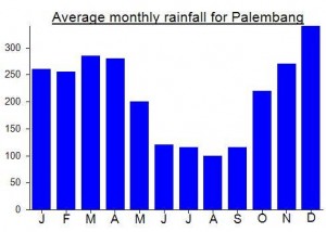
Local Average Monthly Rainfall (mm):
Location
Click on the blue arrow ![]() (top right) to see your current location on the map
(top right) to see your current location on the map
Maman has this to say regarding the top of Patah…
“I now working in Bali as a canyoning guide. Last time I climb, I need two days trekking to the peak, I arrived at the peak at third day morning and one full day to get back. The view in the top is beautiful, the trees like in fairy tale. but if you expect an open wide view with the clouds below, you will be dissapointed by this mount, because the view is only sub-alpine forest of Vaccinium(cantigi) about ten meters high.”
A friend who climbed Dempo recently met a local chap called Ottaman Detwo (also known as Maman) from Pagaralam. It turns out that Maman recently made a pioneering ascent of Patah (involving opening up a trail to the top) in September 2010. It took 6 days to reach the peak. Now he estimates it could be climbed in 5 days total – 3 up, 2 down. I may well put this on the itinerary for 2012.
i’ve been trekking at mt.Bepagut once, the mount beside mount patah. Mt.patah have same entry point with mt.bepagut,if you want to enter it from side of Pagaralam.if you want some info of it contact me at my facebook