
Facts
- Elevation: 2,137 m (7,011 ft)
- Prominence: 1,316 m
- Ribu category:
 Tinggi Sedang
 - Province:
 Nusa Tenggara Timur
 - Island: Flores
- Coordinates: -8.8171, 121.1905
- Rating:


 (10 votes) Add your rating
 Loading...
 - Other names: Amburombu
- Eruptions: 1830, 1888, 1910, 1924, 1938, 1941, 1969, 2013
- World Ribus ID: 69114
Photos


Bagging It!
If you’re travelling across Flores, the relatively easy hike to the summit of Ebulobo is an excellent reason to stop for a night in Boawe on the road between Bajawa (to the west) and Ende ( to the east). The village of Mulakoli (925 m) is the starting point for the hike. It takes around 2 hours to hike through pleasant forest, before you emerge from the trees for a final 30 to 40 minutes climb to the rocky and interesting summit. On clear days you get great views of the valley around Boawae and west to the conical summit of Inerie. Start the hike early, but there’s no need to climb for sunrise, and it’s probably not possible to find a guide before 5:30 am. The information in the 2010 Lonely Planet is almost entirely inaccurate.
At the end of the paved road in the village, turn right at the T-junction and proceed along the road for about 100 m. You’ll then cut past a few houses, including a traditional style house, just before entering the forest and starting the climb. The trail is very steep for about 15 or 20 minutes, but then the trail has a more moderate gradient for all the way to the edge of the forest. After about 30 minutes, there is a clearing in the trees and you can see west towards Bajawa and Inerie towering above the other hills with it’s distinctive summit. After 2 hours of steady hiking you should reach the abrupt edge of the forest at 1,785 m elevation. It’s deceptive, and you still have another 400 m elevation gain to the summit area. The rocky climb is a little steep than in the forest, but the rocks are not lose and hiking is easy.
When you emerge onto the summit areas, you’ll be amazed at the distinctive jumble of rocks around a crater that is more of a cleft striking through the summit from west to east. There are strong sulphur smells that come and go on the breeze. At the point where you come onto the crater rim, you’ll see a small concrete block set into the ground (2,125 m). However, this is not the true summit, which is on the other side of the crater directly to the west. It’s only another 15 mins to drop down slightly to the left and circle around to the crater. It’s not dangerous, but be careful as you do this because the rocks are large and jumbled, and there are some deep holes and cracks. Also, the wind will have dropped in this area and the smells of sulphur can be very strong. Many people go to the highest point (2,137 m) because from here you get the best views to the west to Inerie. The views on a clear day would be magnificent!
Once you’ve enjoyed the solitude of this mountain, you descend the same way and it should take no more than 1.5 hours from strong hikers. This is a really great hike, with not a single piece of litter/trash on the mountain, and a trail and forest that is in very good condition. The area above the forest is interesting and unlike anything you might have seen on other hikes. This is a mountain for those who want to get off the beaten path. The village of Mulakoli is fully awake and alive by the time you get back and you’ll have dozens of kids following you along the road back to the village head’s house.
Bagging information by Andy Dean.
Trail Map
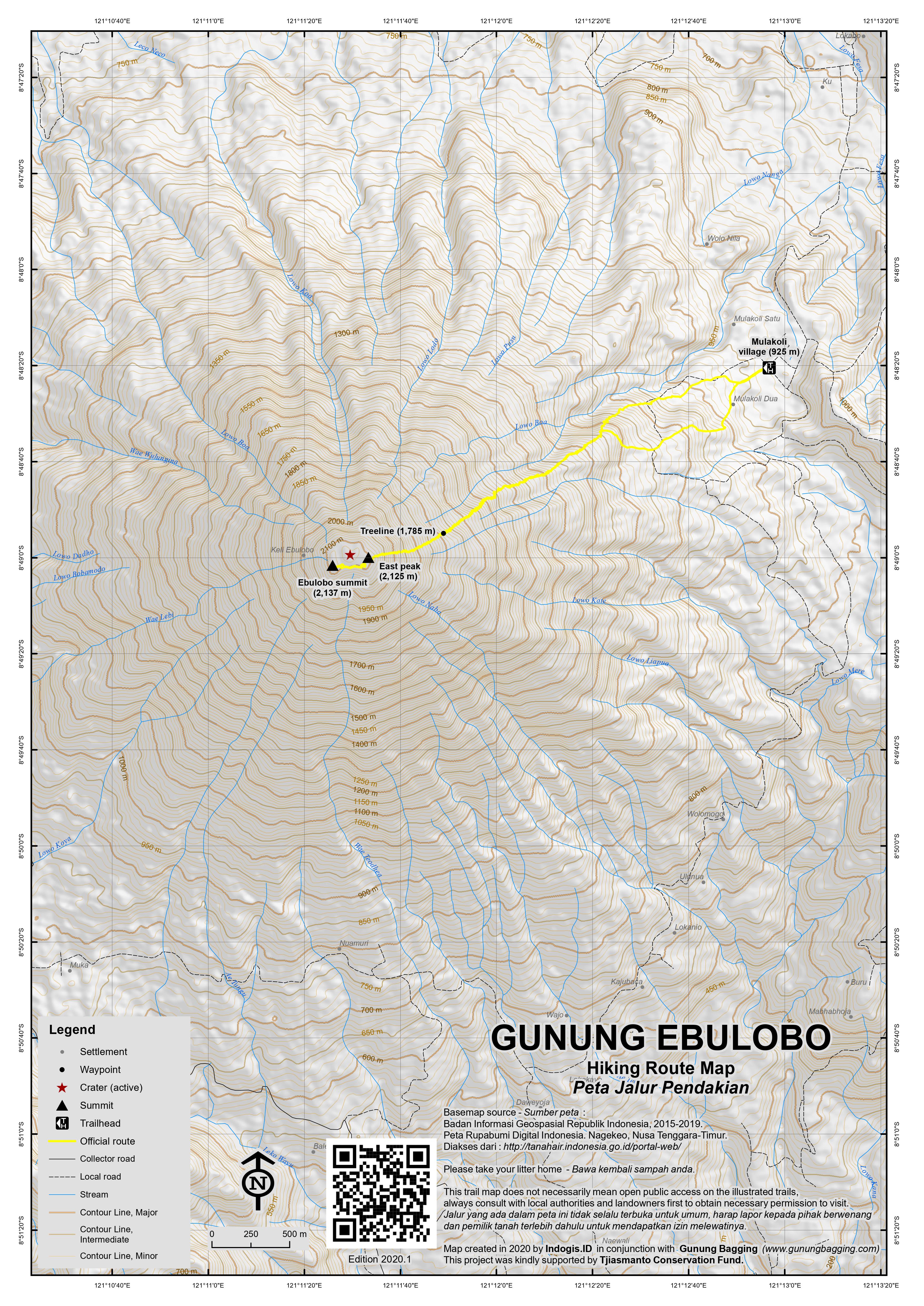
For a high quality PDF version of this and other trail maps, please download from our Trail Maps page.
Practicalities
- Getting there: You will most likely be travelling across Flores – the turning to Mulakoli is about 20 minutes east on the main road from Boawae towards Ende. It’s about 8 km and 20 minutes from this turning to the T-junction that marks the end of the road and your starting point.
- Guides and GPS Tracks: Want a PDF version for your phone? Looking for a guide? Need GPS tracks and waypoints? Gunung Ebulobo information pack can be downloaded here.
- Trip planning assistance: Would you like Gunung Bagging to personally help you in arranging your whole trip? Please contact us here.
- Permits: You need to report to the Mulakoli village head (kepala desa) and request a guide. You don’t need to speak Indonesian, hand signals or basic phrases will suffice and a guide will very quickly be arranged (probably before he’s had chance for breakfast). The guide will cost about Rp 200,000 and a Rp. 20,000 donation as a village guest is required.
- Water sources: There are no sources of water on the hike, and there are not really any warungs (small shops/stalls) in Mulakoli It’s best to buy your water in Boawae the evening before your hike.
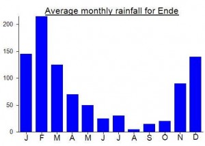
Local Average Monthly Rainfall (mm):
Location
Click on the blue arrow ![]() (top right) to see your current location on the map
(top right) to see your current location on the map
I climbed Ebulobo in mid-December, after staying overnight in Mulakoli.
From Bajawa, my hotel arranged a ‘travel’ (shared taxi), which charged Rp50,000 and dropped me off at the junction shortly after Boawae. A waiting ojek driver took me up to Mulakoli for Rp20,000, and dropped me off at the village centre shop run by Pak Nabas, who also manages the Restagon Homestay. He quickly found me a capable guide, Oktavianus (+6281238244824), who charged Rp200,000 for the hike. Oktavianus also brought along his little brother and his dog Bocil to act as assistants. Unsurprisingly, Bocil turned out to be the most nimble climber of us all and explored wide areas of the forest and mountain top.
We set out from the homestay at 03.00, hoping to be at the top around sunrise. Turn right at the junction a few hundred meters after leaving the village, and then take the first footpath into the woods on the right. As on Inerie a few days before, there was a heavy pre-dawn rain shower, which in this case forced us to take a long rest at a farm hut, which Oktavianus called Pos 1 (altitude 1125m). This is a solid concrete hut with a covered wooden terrace that could be used for camping. There are also forest campsites called Pos 2 (1231m), and Pos 3 (1650m), both of which have space for about half a dozen small tents.
We were still in the forest at dawn (which is around 04.45 in Flores at this time of year), and reached the crater rim at 07.00. Oktavianus then stayed at the crater rim, while his brother and Bocil accompanied me across the rocky dip and up to the summit. The views from here impressed me even more than on Inerie, with the Flores Sea and the Sumba Strait visible north and south coasts visible, and Flores’s stunning mountain landscapes to east and west.
We returned to Mulakoli at 12.30, after making a long stop to feast on oranges from a tree beside Pos 2. From the homestay, I took an ojek back down to the main road and caught a passing bus to Ende (3 hours, Rp50,000). Pak Nabas charged me Rp350,000 for the homestay. While the family were very hospitable and provided 3 rice-based meals, the sleeping room was barely big enough for a mattress and contained numerous ants, and the bathing water was limited. Staying in Boawae, and biking in directly to the start of the trail might be more comfortable.
Thank you for the reference to Oktavianus, John. While a month or so before our planned hike he committed to providing us two guides, by the time we tried to reconfirm, he had disappeared without trace. Fortunately Ibu Lupita, owner of the simple but well-kept Wisma Nusa Bunga in Boawae (highly recommended!), managed to find us a pair of guides who turned out to be both very good and very helpful: Marto (+62 852 3893 6872) and his friend Boni. They informed us that Oktavianus had just moved to Bali and probably changed his phone number.
This mountain is indeed very enjoyable, although contrarily to what Dan states in the “Bagging it!” section, we found it to be very steep all the way except for the first 20-25 minutes (when you pass through the coffee, vanilla and vegetable fields). Very damaged (and sometimes completely unrecognizable) path, especially above the treeline, due to heavy rains over the last two month. A lot of loose rocks as a result.
We hiked up Gunung Ebulobo in May 2017.
Had a young man Peter from the village as our guide (his phone number : 085-338-261 696), we paid 200 000 for him to guide us and another 20 000 village fee.
It took us nearly 3 hours to reach the top, the first half was through the forest with many trails, so it was quite helpful to have a guide with a machete.
There are quite nice views from the upper part of the trail at Inerie and surrounding area.
Once at the top, we did not spent that much time there as the wind was turning around and was bringing quite strong sulfur fumes.
This was a very nice day trip and not as demanding as Inerie.
Me and a friend went up Mt Ebulobo a few days ago. We went to Mulakoli the night before and asked to meet the chief (more like a mayor than a chief in the traditional way) but were pointed to Bapak Franz (if I remember the name correctly), who is the deputy mayor, instead. His house is a few meters away from where the trail starts. We were prepared to camp but were invited to stay in his house and made an early start just after 2 am. Finding the trail was easy with the GPS trace. There are a few places where large trees have fallen on the trail (branches, leaves and all).
The views from the top were fantastic and I could smell very little activity (sulphur) while on top of it. We also walked around the crater, which is a bit tricky if you are in a cloud.
i also did this one with dan.you wont have to wait long for a guide to appear in molakoli.we had bad weather at the top but i can imagine there would be great views of adjacent inierie.we did a circut of the crater rim but be careful of the sulfur gases and big holes.
what i found a bit strange was that the night before in boawae the only shop that was open was a phone shop.it seems these days even in flores phones are more important than food.just as well i had some freeze dried icecream and salt and vinegar chips.a very nutritious meal.
Climbed this one last week – a fabulous mountain, though we weren’t especially lucky with the weather! We flew to Ende – the approach includes a brilliant panorama of the Gunung Iya volcano on the peninsula south of the town. Getting to Boawae from the airport, we had the usual transport troubles you get everywhere in Flores – either pay Rp20,000 for a horrendously cramped, noisy and dangerous minibus or fork out an extortionate Rp600,000 which is the norm on Flores – probably due to some kind of cartel in operation. Luckily we found a guy who would drive us to Boawae for 300,000 – a reasonable price given the terrain and the distance.
By the time we got to Boawae it was eerily quiet. It was about 8pm but the only shop open was a mobile phone shop! Luckily they had some water but we had to go a night without a meal so do bring some food with you for this one!
The folllowing morning we had to wait around for over an hour for 2 ojeks because lots of the usual ojek guys were at some local party! Finally we got up to Mulakoli.
It seemd as though we had a guide before we could even get off the motorbikes! Fantastic! I thought the chap who marched out of his house was going to take us to someone who would be our guide, but no, he just continued marching all the way up the mountain in his flipflops and with no food or water whatsoever!
It took us about 3 hours to the top and then 15 minutes over to the true high point. A great jumble of boulders and gases. We actually did a circuit of the top – the last bit was a little difficult and needed great care both to avoid the worst of the gases and to not fall down massive holes in the ground!
We were back down in about 2 hours and the friendly village head arranged ojeks back to the main road for us before we could blink. We then set off on a long search for some breakfast!
Mulakoli is one of the most pleasant villages we’ve been to in Indonesia – really nice people and we had an almost identical experience. Hopefully more people will climb Ebulobo (a fantastic mountain) and contribute a little money to the local economy.
EBULOBO IS THE MOST BEAUTIFUL MOUNTAIN. FROM THE TOP OF THE MOUNTAIN WE CAN SEE MANY INTERESTING VIEWS. IF ANYONE WANTS TO ASK THE MOUNTAIN EBULOBO CAN CALL ME. I will be able to take you to the people who will take you to the summit of the mountains. FREE…