
Facts
- Elevation: 640 m (2,100 ft)
- Prominence: 640 m
- Peak category:
 Spesial
 - Province:
 Maluku (Moluccas)
 - Coordinates: -4.5225, 129.8808
- Rating:


 (7 votes) Add your rating
 Loading...
 - Eruptions: 1586, 1598, 1609, 1614-15, 1632, 1635, 1683, 1690, 1712, 1722, 1749, 1762, 1765, 1773, 1775, 1778, 1816, 1820, 1824, 1835, 1855, 1890, 1901, 1988
Photos


Bagging It!
Banda Api is a small but very active island volcano in the remote Banda islands. It has been observed and written about for centuries since it was a key location for the trading of spice when the British, Dutch and Portuguese sought the vast quantities of nutmeg on these islands – particularly Run / Rhun island. The last major eruption was in 1988 but there remains minor fumarole activity near the summit.
Since the new fast ferry from Ambon started in 2016, tourist numbers have increased and getting to Banda Neira is a lot easier than is used to be. It is also a brilliant place to visit at the moment, with a perfect balance of adventurous tourists and friendly local people. The local food is excellent too, with nutmeg coffee, nutmeg tea, nutmeg jam and nutmeg pancakes, and so on! Based on the current 2017 fast ferry schedule you will need 5 or 6 days total to get to Banda and back from Java or Bali and this is an ideal length of time to spend in such an interesting and beautiful place.
Banda Api is less than five minutes by little boat from the market jetty in Banda Neira which is the most populated island in the group and where most guesthouses are. A boat crossing can easily be found for Rp10,000 throughout the day but if you want to start before light you will probably have to pay more.
An early start makes sense because the hike starts at sea level and there is little shade, probably because much of the vegetation re-grew after the 1988 eruption so there are no huge, shady trees here and the terrain is challenging, with steep loose volcanic scree. Three litres of water is recommended per person, to be on the safe side.
The trail starts to the right of a couple of houses and there appear to be no major junctions so once you are on the trail you should not have problems route-finding and therefore it can be done without a guide (but best not done alone). Allow around 4 hours for a return trip including rests en-route and at the summit (just over 2 hours up, just under 2 hours back down), although fast hikers might manage it in 3 hours total.
There are few notable landmarks on the way up other than a couple of signs and a shelter at an elevation of around 100m. When you reach 300m above sea level, there are some good views back down to Banda Neira town and airport, plus part of the crescent-shaped Banda Besar. From around 500m above sea level, the path becomes solid as you hike up what is presumably old lava flows. From here the views are magnificent – over to Banda Neira and its highpoint little Gunung Papenberg.
After a metal pole – possibly vulcanological equipment – the vegetation grows much sparser as you reach the highest parts of the volcano. Soon the summit can be seen straight ahead, just a five-minute walk away, past a couple of what appear to be small, shallow, old craters. Certain parts of the ground here are hot and smoke finds its way out of small crevises. Suddenly you are on the crumbly rim of the eastern side of the crater – luckily for those wishing to reach the highest point it is indeed the highest side. A couple of metal poles mark the edge of the rim in places, but extra care needs to be taken here as the drop into the deep crater is considerable.
From the rim and the summit, the views out west towards Pulau Ai and Pulau Run/Rhun are wonderful and looking roughly north you should be able to see little Pulau Manukang, the uninhabited island that is noticed first when taking the boat into Banda from Ambon. Some maps and sources of information give the summit elevation at around 666m, but this seems to be a little over what most GPS devices find. Perhaps some height was lost in the 1988 eruption.
The route back down Banda Api is the same as the ascent. Given the unstable and slippery terrain, some may find it harder descending than ascending. Once back down at the foot of the volcano it is usually pretty straightforward to find a boatman willing to take you back over to Banda Neira. You can always ask at one of the houses if there is no boatman around.
A few decent places to take photographs of Banda Api are worth mentioning. Firstly, from Benteng Belgica on Banda Neira. This view is actually on the brand new 2017 one thousand Rupiah note (replacing the image from Ternate and Tidore in Maluku Utara). Secondly, from Benteng Hollandia above Lonthoir on nearby Banda Besar (a ten-minute boat ride away). This is the classic shot of Banda Api from the south, from under a cluster of nutmeg trees and over turquoise sea. Finally, the view from tiny Pulau Neilaka, off Pulau Run, is gorgeous too, with Banda Api a perfect cone in the distance to the east.
For an interesting and informative account of the Banda islands and their historical significance read Nathaniel’s Nutmeg by Giles Milton.
Bagging information by Dan Quinn (March 2017)
Trail Map
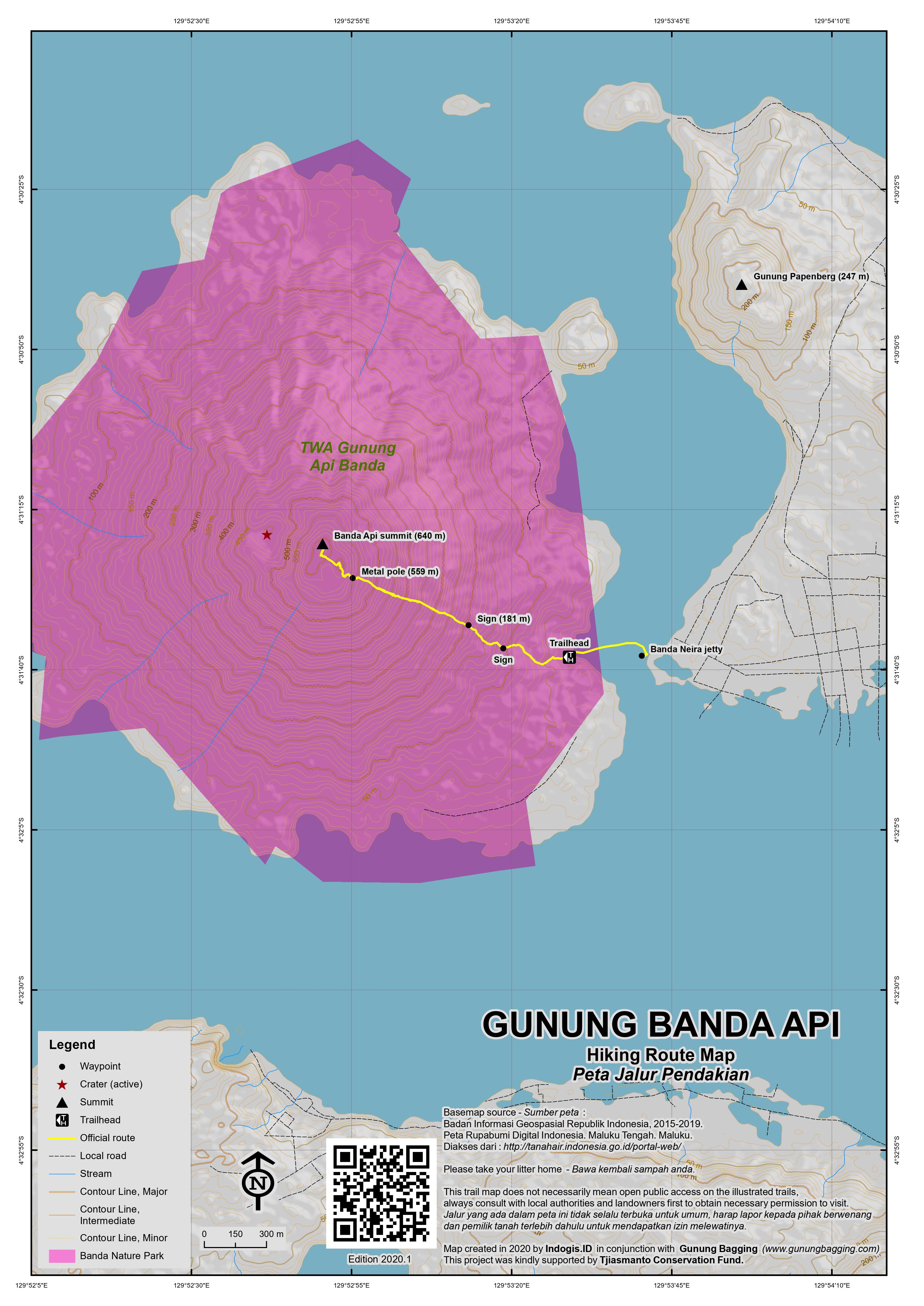
For a high quality PDF version of this and other trail maps, please download from our Trail Maps page.
Practicalities
- Getting there: As at March 2017, there are no flights from Ambon to Banda Neira but they are expected to resume in a month or two. Large and very economical (but slow) Pelni ships also stop here, but only once a week or so. They take around 12 hours from Ambon. The best option is the Express Bahari fast boat from Tulehu harbour on Ambon island which takes about 6 hours and costs Rp415,000 one way. As at March 2017, it is scheduled to leave Tulehu at 9am on Tuesdays and Saturdays, and return from Banda to Tulehu on Wednesdays and Sundays, meaning you can have a 4 or 5 night stay in the Banda islands which is ideal. Check with your hotel or via a local diving operator as the schedule may change.
- Guides and GPS Tracks: Want a PDF version for your phone? Looking for a guide? Need GPS tracks and waypoints? Banda Api information pack can be downloaded here.
- Trip planning assistance: Would you like Gunung Bagging to personally help you in arranging your whole trip? Please contact us here.
- Permits: Not required but take a photocopy of your passport photo page just incase.
- Water sources: None available so take enough supplies with you – ideally 3 litres per person.
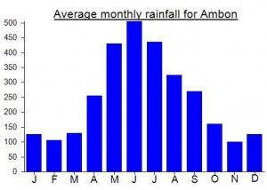
Local Average Monthly Rainfall (mm):
Location
Click on the blue arrow ![]() (top right) to see your current location on the map
(top right) to see your current location on the map
Thanks to all for the tips. I tried this morning as a tourist and did not manage, understandably now as my shoes were not up to the needs. Reaching 400 meters was it all and fortunately all the other parts of the trip were splendid. We particularly liked Ai island with a nice guide.
As per gunung api bagging I was really sad to see people who climbed letting their plastic stuff (water bottles, shoes) on the path.
Gunung Api was my first hike of the year (2022). It took me 2h15 up, 2h down. The scene from up there is worth all the pain of the ascent. By the way, is it a difficult walk, or am I just getting old? The steep portion, from altitude 200 to altitude 550, is a straightforward trail up the hill, with an average slope over 30%. It is a hellish mix of screes and muddy pathways, treacherous roots and unstable rocks. Add to that the high temperature and saturated humidity, and you can expect to be covered with sweat and mud within the first half hour of the ascent… So yes, bring with you a lot of water. 2 liters is a minimum, add 1 liter to be on the safe side.
I would also say that, if the way up is strenuous, the return down is simply grueling. And excessively dangerous: once again, hidden roots, slippery and unstable rocks, can surprise the most experimented hikers, and I would not advise anyone to go up there without a guide, not that much to show you the way (the trail is obvious) but to be with you in case of an accident.
As is the Lionair tradition, my late evening flight from Surabaya to Makassar was delayed. Luckily it was the same aircraft used to continue on to Ambon afterwards the following morning, so after a couple of large cans of beer from Makassar Airport’s Circle K shop things were very much back on track! From Ambon airport I got a taxi/private car with driver to Tulehu for Rp150,000 which is probably about as good as you can get for what can take up to almost an hour. Try Pak Lucky on 0813 43291575 if you want to reserve in advance. Tulehu harbour (pronounced with the emphasis on ‘HU’ at the end) is a friendly place and assuming you’ve arrived on the correct day you’ll almost certainly meet other tourists waiting to buy a ticket for the fast boat to Banda as the boat is normally comprised of at least 50% tourists. It has apparently never sold out so far but I would still recommend getting there in plenty of time (I.e as soon after 8am as you can). Capacity must be around a hundred total. For the published 9am departure time read ‘probably more like 9.45am but possibly as early as 9am’. The crossing normally takes around 6 hours in reasonably calm conditions. The Blue Motion dive centre website seems to have the most up-to-date details on transport to the islands (including if/when the flights will resume). On the boat I had a good chat with Peter, a Finnish guy who along with his partner spends several months a year in the Banda islands and knows them incredibly well. They are in the process of building their own boat.
The first island in the group you pass in the uninhabited Pulau Manukang – an uninhabited rock with steep cliffs on all sides. By this time the volcano will be clearly visible and half the boat will probably be taking picutres. As you enter the channel between Banda Neira and Banda Api the atmosphere is quite special indeed – it feels like you are entering a different realm of some sort. There are some lovely little restaurants in Banda Neira – best of all is probably the new Spice Island Cafe run by Eliza from the USA and her local husband, where you can also buy packets of spices and get information on doing tours to other islands. Make sure you try the avocado and lime smoothie – it really is unbelievably brilliant. I ended up drinking about 8 over 5 days! The nutmeg coffee is also a must-try. You can just about see the top of Banda Api from here. The cafe next door is good and very friendly too (and has cold Bintang!) and seems to be a good place to meet other travellers. There is 3G on Banda Neira now so you can keep track of life outisde Banda quite easily too.
If you’re lucky, you’ll cross paths with Koko, a very friendly man originally from Ambon with excellent English skills. He runs the Harmoni Cafe about 10 minutes walk from the centre of town and has a great taste in music. He can also help you put together trips. 0823 9900 0085. He told me there is sometimes an increased amount of smoke at the top of Banda Api but that fortunately the prevailing wind tends to blow it further west.
I arranged a crossing to Banda Api for just after 5am with Pak Lani 0812 40821579 for Rp50,000. Much cheaper if you wait til daylight but probably worth the extra if you don’t want to get sunburnt! It took me 2hr 20min to the summit with a serious hangover and just 1hr 10min back down. Fabulous views and mercifully overcast the day I went up. A german guy tried descendding to the north along the crater rim the following day. He got back eventually, but not without numerous scratches on his legs – not recommended!
As John H says, Gunung Papen/Papenburg (who was he?) on Banda Neira is worth a wander up. I did it later the same day and it took about 2hrs return from the centre of town. The undulating ridge offers occasional views of Banda Api, but it is also worth hiking for the wildlife. I saw a cuscus up close on the summit ridge. There are about 3 minor tops along the ridge. The ‘ruined house’ near the starting point is no longer ruined but lived in by a friendly family from Central Java. On the way back down I was offered a greatly appreciated kelapa muda by a guy working in the fields.
Some of the finest views of Banda Api are from the west, especially from the tiny island of Neilaka which is a great spot for swimming. Look out for hundreds of hermit crabs here – it seems the entire beach is moving in places.
There’s not much left of Nathaniel Courthope’s ‘English Fort’ on Run and it’s unclear which ruins are that old and which more recent. Worth a visit, though, even just for the view of Run bay and Manukang island in the distance.
I managed to book my return ferry ticket the day before leaving. It seems to be the case that they don’t start selling them until the boat arrives, so you have to wait until around 3pm the day before. I was taken to the house of the woman in charge of selling them, basically for peace of mind as I had a tight schedule for getting back to Java and going on another trip soon afterwards. As it turned out, I would have been fine just waiting until the next morning. But it is nice to avoid dealing with the usual disorderly queues.
Do note, however, that the fast ferry may not leave from the same place it dropped you off! I checked the ferry was at the usual harbour the afternoon before and assumed that that would be where to board the next morning. The next morning it has disappeared as a couple of large Pelni ships needed to use the harbour. The fast ferry had docked a good 15min sweaty walk north. It departed late at around 9.50am – cause for concern for those of us booked on the 18.20 Batik Air flight from Ambon to Surabaya. There was a fair bit of swell in places too, but thankfully we arrived back in Tulehu just after 4pm so sufficient time for the Batik Air flight the same day, and plenty of time for the later Batik flight to Jakarta (8pm ish).
Excellent info. I can’t wait to hike Api next week. Thanks for your detailed report.
While you’re staying on Banda Neira, you can also climb Gunung Papenburg (247m), the highest point on the island.
Follow the west coast road out of town, pass the airport runway, then take the concrete path on the left up to the blue pumping station. Fork left into the forest, pass the ruined house and head up the ridge.
An alternative route is to continue past the concrete path for a further 1 km, where there is a road on the right and a well-defined path into the forest on the left. Take the path into the forest, turn left at the crossing after 200m, then after 200m fork left. This path brings you onto a ridge on the east flank of the hill, joining the main ridge near the top at a nutmeg plantation.
On either route the best views are on the way up. The path terminates at a gravesite twenty meters below the summit, which is accessible but wooded on all sides.
We climbed Gunung Api twice around New Year 2012.
This webpage has a clear map of the area, showing Pulau Gunung Api, with Banda Neira, the main transport and commercial hub of the Bandas, right beside it.
http://www.liveaboards-indonesia.com/destinations/banda_islands.htm
There are a few fishermen’s houses but no homestays on Pulau Gunung Api, so you’ll need to overnight in Banda Neira.
(Actually you’ll need to stay a few nights in Banda Neira. Flights from and to Ambon by Nusantara Buana Air ran twice weekly in 2011 but were suspended at the start of 2012. Pelni ships pass through 2 or 3 times a week, in transit between Ambon and destinations elsewhere in Maluku and Papua. We recommend staying at Vita Guesthouse and eating at Mutiara.)
From Banda Neira, charter a ketingting (motorized canoe) from the ketingting dock near the Delfika 2 guesthouse, or get your guesthouse to arrange one (10,000rp round trip). Cross the strait (3 minutes) to the dock on Pulau Gunung Api and arrange a pick-up time with your boatman.
We allowed three and a half hours, comprising 2 hours ascent, half hour summit wandering and 1 hour descent. 3 hours would be ample for speedsters, 4 to 6 hours for slower hikers. Casual tourists without hiking shoes or legs should probably give this a miss as the trail is steep and pebbly, with too few hand supports for comfort.
Take loads of water. Paleskins will need dollops of sunscreen as the scrubby forest has lots of exposed patches.
Routefinding is easy; follow the upward path from the dock! There’s a shelter ten minutes up, a few metal signs along the way and great views back toward Banda Neira. The middle third is the steepest. At 500m you emerge from the forest, and then reach the lip of a shallow crater, which you skirt to reach the top at 636m. The summit is on the edge of a precipice, so don’t walk straight over! There are small fumeroles and warm rocks but no hints of an imminent eruption.
Be careful not to lose your bearings in mist while touring the crater area. We made our first ascent at crack of dawn and our second in late afternoon, but ended up in cloud cover both times! In fine weather the view should extend across the entire Banda archipelago. The top seemed to be clear for at least part of every day, so the best tactic might be to climb up in the morning and wait as long as necessary for a clear view; you could hail a ketingting from the shore for the return crossing to Banda Neira.