
Facts
- Elevation: 2,168 m (7,113 ft)
- Prominence: 638 m
- Peak category:
 Spesial
 - Region:
 Peninsular Malaysia
 - Malaysian state: on the border of Kelantan and Perak
- Range: Banjaran Titiwangsa / Main Range
- Coordinates: 4.7608, 101.3733
- Rating:

 (2 votes) Add your rating
 Loading...
Photos


Bagging It!
Gunung Yong Yap is considered to be one of the tougher treks in Peninsular Malaysia, with leeches, sandflies and even the vague possibility of Malayan tigers! But it all depends on which route you take as there are several options available, all with distinct qualities. There are two main trailheads and three main routes. The word ‘yong’, used for the similarly-named Gunung Yong Belar, is apparently a very old local word meaning ‘older or eldest brother’ so it could perhaps be understood to refer to the respect with which local communities regard these mountains.
Kuala Mu, Perak
This route starts in the north at an Orang Asli village (Kampung Gepeh Hilir) at Kuala Mu (640m) and it has the considerable advantage of allowing a dayhike of Yong Yap, albeit at 15-hour dayhike and one that does not pass by Gunung Bubu and Gunung Tok Nenek. A 4WD was once needed to reach this trailhead but Kuala Mu is now reachable with an ordinary car and the area is especially popular at weekends with domestic tourists who want to get out of the towns and cities and experience rural life in a scenic area. This usually involves renting a very affordable Orang Asli hut to stay in, though phone signal and electrical power for charging your phone may be seriously limited.
The trail leads via Pintu Rimba (820m), Kem Sangkut (1,085m), Bukit Tampoi (1,115m), Kem Sungai Cinak (1,085m, near what was formerly known as Kem Pondok) and Last Water Point (1,835m).
Rengil, Lojing, Kelantan
The southern route is from Rengil (660m), in the state of Kelantan but not far from Cameron Highlands. It is common to take a 4WD beyond Rengil to reach the trailhead by the river. Most hikers who start here in the south as opposed to Kuala Mu are here to do YYBTN (Yong Yap-Bubu-Tok Nenek), a full circuit of three distinct peaks over 42 kilometres. Ordinary hikers tend to do this over three days, with two nights camping in the forest, though it could be accomplished in two days if you set out incredibly early with a suitable guide and team. There are even mountain runners who do the whole thing in one go with headlamps and incredible stamina. Whichever route you choose you will face multiple river crossings.
The trail leads via Kebun Durian (durian plantations, 685m), Sungai Biru (750m) and Simpang Y (900m). This is an important junction as you can decide whether or not to hike clockwise via Tok Nenek (1,905m) and Gunung Bubu (1,974m – not to be confused with the separate mountain range near Kuala Kangsar) or anti-clockwise via Kem Agas. It is also possible to only hike Tok Nenek then return the same way, or only hike Gunung Yong Yap via Kem Agas and return the same way, shunning Tok Nenek and Gunung Bubu. The following description assumes you hike clockwise, but it could be done anti-clockwise too, or simply using only one of the possible two routes in both directions from the lower trail junction to the upper trail junction. A map is helpful here to avoid confusion between the various options.
Heading west from the lower Simpang Y (900m), the clockwise trail leads via Kem Lengkuas (1,095m), Kem Kicap (1,125m), Kem Hari (1,210m) and Kem Belumut (1,480m) which is a good camp spot as there is a water source. It then ascends steeply up onto Tok Nenek which offers fantastic views in all directions and was formerly known in the colonial era as Mount Table and Chair. This rocky summit is one of the most important landmarks in the whole of the Titiwangsa Range.
The trail continues via Kem Puncak Kambing (1,885m) and Puncak Kayung (1,903m) which is almost as high as Tok Nenek, before dropping down to the col (Low Point, 1,695m). Then it is straight up Gunung Bubu, down the other side and up to the upper Simpang Y (1,915m) which is the upper junction where the clockwise or anticlockwise trails meet higher up. Beyond here, the trail enters moss forest before reaching the summit of Gunung Yong Yap.
Descending clockwise from the upper Simpang Y, the trail leads via Kem Last Water Point (1,760m), Kem Balak Pecah (1,675m), Kem Sungai Y Kecil (1,340m), Kem Agas (1,135m), and several more streams before reaching the lower Simpang Y (900m) again.
Trail Map
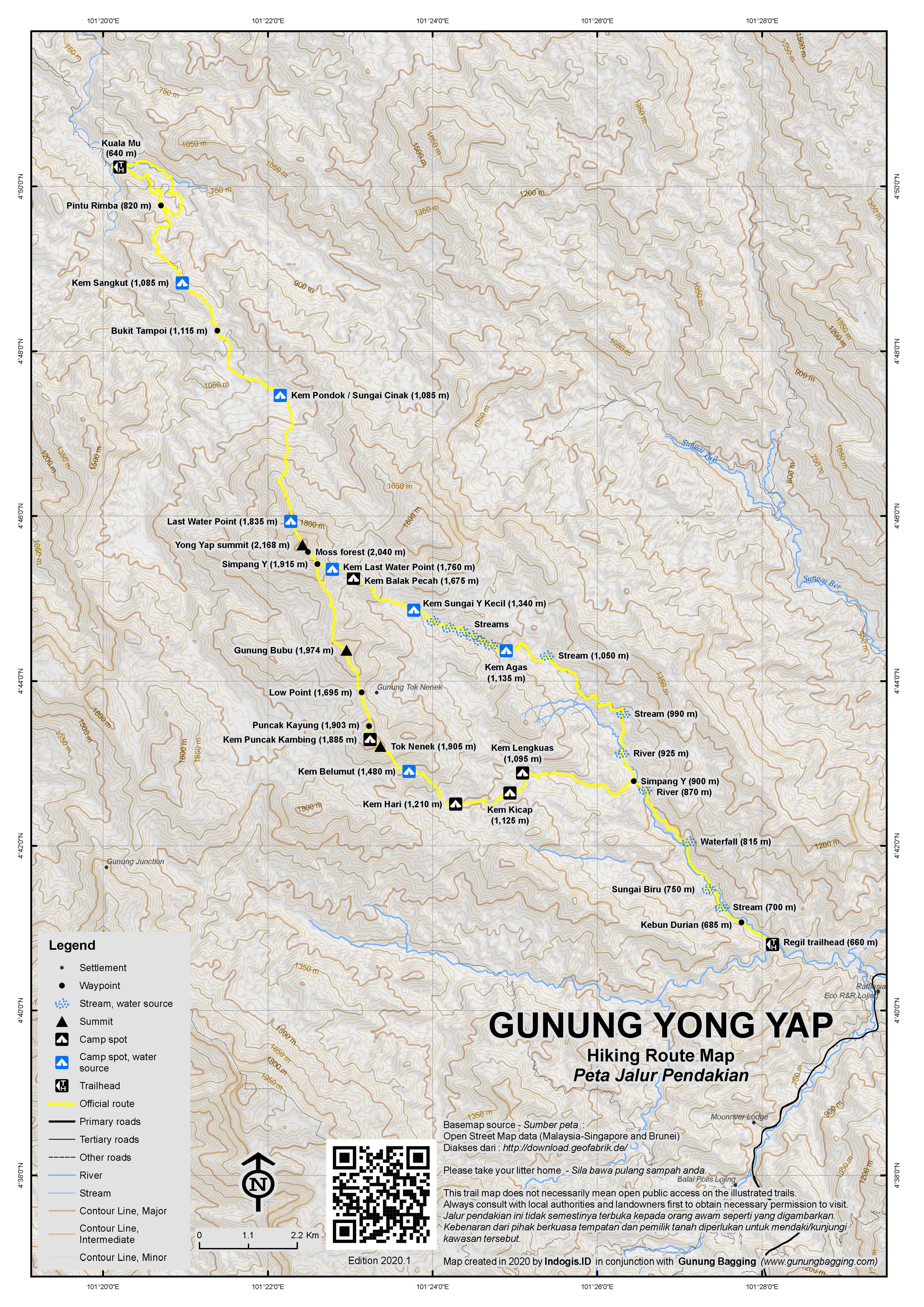
For a high quality PDF version of this and other trail maps, please download from our Trail Maps page.
Practicalities
- Getting there: For Malaysian domestic flights and flights within Southeast Asia, for example to Kuala Lumpur, we recommend Baolau. Ipoh is the closest train station.
- Trip planning assistance: Would you like Gunung Bagging to personally help you in arranging your whole trip? Please contact us here.
- Permits: A guide is mandatory and permit required. You can register and pay for an e-Permit online from the Forestry Department of Malaysia website.
- Water sources: Available as far as Last Water Point (1,935m) on the Kuala Mu trail, as far as Kem Belumut (1,480m) on the clockwise trail via Tok Nenek, and as far as Kem Last Water Point (1,760m) on the anti-clockwise trail via Kem Agas.
- We recommend Safety Wing as travel insurance for overseas travellers and tourists hiking up to elevations not exceeding 4500 metres.
Local Average Monthly Rainfall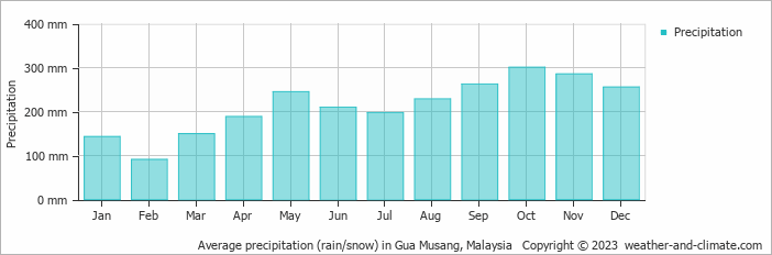
Location
Click on the blue arrow ![]() (top right) to see your current location on the map
(top right) to see your current location on the map