
Facts
- Elevation: 2,161 m (7,090 ft)
- Prominence: 775 m
- Peak category:
 Spesial
 - Region:
 Peninsular Malaysia
 - Malaysian state: on the border of Kelantan and Perak
- Range: Banjaran Titiwangsa / Main Range
- Coordinates: 5.1400, 101.4833
- Rating:


 (4 votes) Add your rating
 Loading...
 - Other names: Hulu Sepat
Bagging It!
Like neighbouring Gunung Chamah, Gunung Ulu Sepat is rather remote and requires a well-planned itinerary and a larger group of hikers to be able to cover the substantial transportation costs needed to get to and from the trailhead. Ulu Sepat is located in Hutan Belum and Orang Asli villages are common here. Those who hike Ulu Sepat along with Gunung Chamah (requiring 4 or 5 days in total) almost always begin with Gunung Chamah, so the route description for the Ulu Sepat section of that traverse is in reverse here.
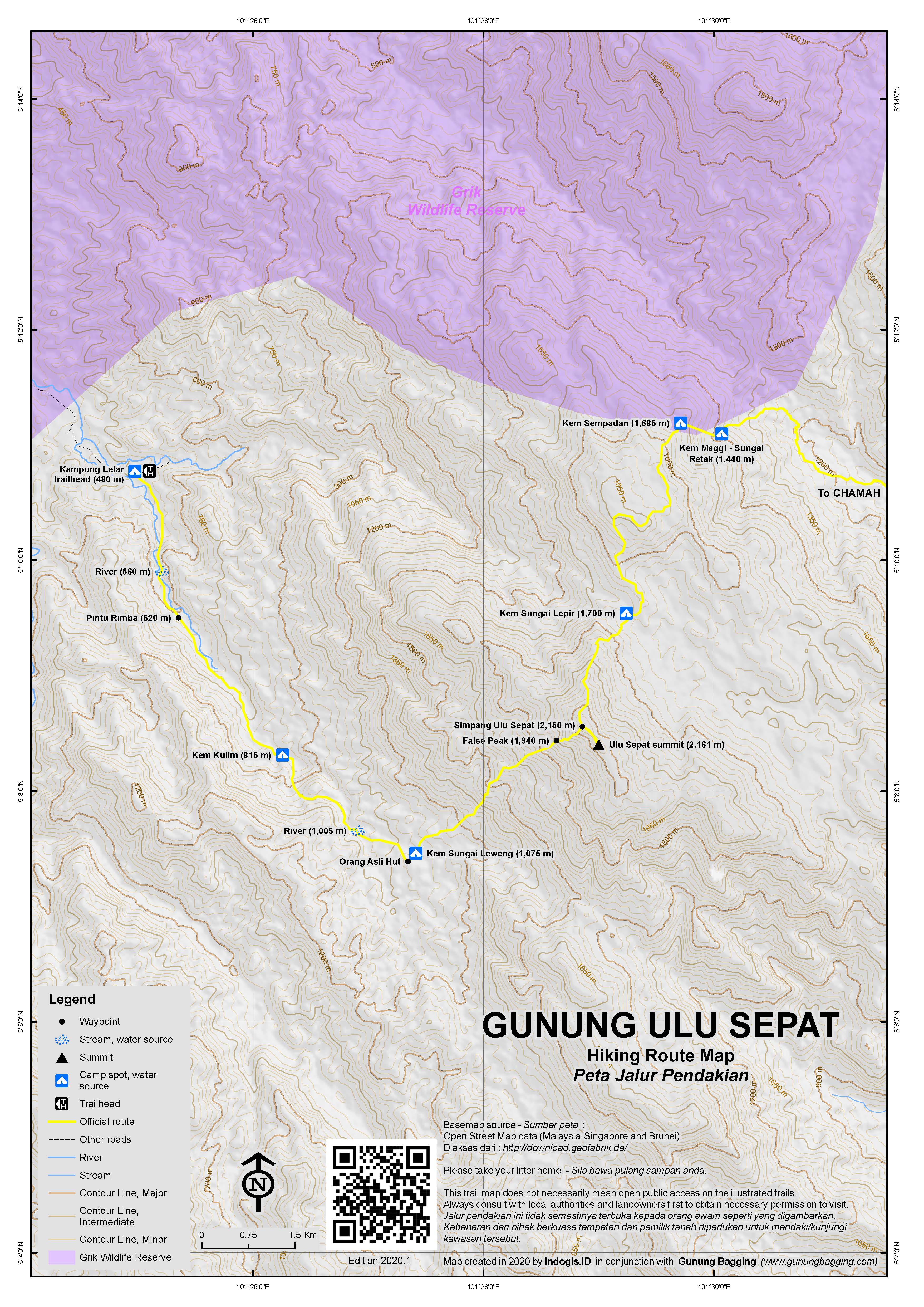
For those doing Gunung Ulu Sepat on its own, it usually takes two or three days in total. Most people take a 4WD from the town of Lasah / Bawong to Kampung Lelar (480m). This usually takes around 2.5 hours. Alternatively, if the state of the 4WD track from Lasah is less than ideal, a boat can be taken from Banding across Tasik Temenggor, although this is a more expensive option as a 4WD is still required on the other side of the lake.
From Kampung Lelar it is a 4 hour hike with river crossings required via Pintu Rimba (620m) and Kem Kulim (815m) to Kem Sungai Lenweng (1,075m). This is, for most hikers, the real ‘basecamp’. Kem Sungai Lenweng is a very small hamlet with just a handful of Orang Asli remaining rather than moving down to Kampung Lelar. There is a shelter available here which can usually be rented by hikers.
On Day Two, the trail ascends much more steeply via False Peak (1,940m) to Junction / Simpang Ulu Sepat (2,150m) from where it is a short distance to the summit. Most hikers will have made it to the top in around 4 hours. Views are quite limited at the top due to the tall vegetation. There are no water sources here. Assuming you are not continuing on to Gunung Chamah, the descent is the same trail that you came up on and takes most hikers between 2 and 3 hours. That means a total of around 6 or 7 hours not including breaks. Depending on what time you began from Kem Sungai Lenweng, you will either spend another night there before descending all the way to Kampung Lelar and a waiting 4WD the following day or else make it out the same day, requiring another 3 hours or so and taking the day’s total hiking time to 9 or 10 hours, not including break time or the 2.5 hours by 4WD from Kampung Lelar to Lasah/ Bawong.
To combine Ulu Sepat with the slightly higher Gunung Chamah (requiring 4 or 5 days in total and rarely done in the Ulu Sepat to Chamah direction) the trail continues north from Simpang Ulu Sepat (near Ulu Sepat summit), dropping down to Kem Sungai Lepir (1,700m) before ascending once more and dropping down again via Kem Sempadan (1,685m) and Kem Maggi (1,440m) towards Kampung Rekom and Gunung Chamah. Many hikers who have completed the full traverse say that the nicest mossy forest in Peninsular Malaysia is to be found between Ulu Sepat and Chamah, something that would be missed were the two mountains to be hiked individually.
Trail Map
For a high quality PDF version of this and other trail maps, please download from our Trail Maps page.
Practicalities
- Getting there: For Malaysian domestic flights and flights within Southeast Asia, for example to Kuala Lumpur, we recommend Baolau. Either via 4WD from Lasah or boat and 4WD from Tasik Temenggor.
- Trip planning assistance: Would you like Gunung Bagging to personally help you in arranging your whole trip? Please contact us here.
- Permits: You can register and pay for an e-Permit online from the Forestry Department of Malaysia website.
- Water sources: Available at Kem Kulim and Kem Sungai Leweng. Available at all other major camp spots further north for those doing the onwards traverse to Gunung Chamah.
- We recommend Safety Wing as travel insurance for overseas travellers and tourists hiking up to elevations not exceeding 4500 metres.
Local Average Monthly Rainfall
Location
Click on the blue arrow ![]() (top right) to see your current location on the map
(top right) to see your current location on the map
Although I missed both Ulu Sepat and Chamah this year due to there not being enough people to make it affordable (very high 4WD prices), I have already started to think about how best to tackle them in 2025. Most groups start with Chamah, but I think that starting with Ulu Sepat is preferable, as it is possible to avoid any camping in tents (and therefore less weight in backpacks). There are Orang Asli huts available to rent at Sungai Lenweng and Kampung Rekom, so night one could be at Sungai Lenweng, then a very long Day 2 over Ulu Sepat and down to Kampung Rekom. Day 3 up Chamah and back down to Kampung Rekom, then Day 4 out to Kuala Betis near Gua Musang. 4 days, 3 nights, no camping in the forest. If anyone reading this is interested, let me know and I will keep you informed as plans materialise.
I join Malaysian groups in 2025. First I will go to Ulu Sepat (if my leave is approved) and next June it will have CUS (Chamah – Ulu Sepat).
Excellent. Let me know the dates for CUS and perhaps I will join…