
Facts
- Elevation: 1,265 m (4,150 ft)
- Prominence: 999 m
- Peak category:
 Spesial
 - Region:
 Sarawak
 - Range: Banjaran Mulu
- Division: Bahagian Miri
- Coordinates: 3.9392, 114.8492
- Rating:
 (Bagged it? Be the first to rate it)
 Loading...
 - Other names: Previously listed as ‘Tutoh’ after the local river.
- World Ribus ID: 69221
Bagging It!
This peak is on the other side of the Tutoh river from the main Mulu range. It may have a completely different name – Bukit Pelamau is seemingly the name of the lower ridge to the south-west. Mulu Park staff are not sure on name or elevation, presumably as it lies outside the boundary in a rarely-visited and unexplored area.
Practicalities
-
- Getting there: For Malaysian domestic flights and flights within Southeast Asia, for example to Kota Kinabalu or Kuching, we recommend Baolau. Fly to Mulu Park with MASWings from Miri or Kuching.
- Permits: Register with locals and take a local guide from the area.
- Water sources: Unknown.
Local Average Monthly Rainfall (mm):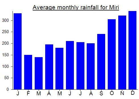
Location
Click on the blue arrow ![]() (top right) to see your current location on the map
(top right) to see your current location on the map