
Facts
- Elevation: 3,676 m (12,060 ft)
- Prominence: 3,676 m
- Ribu category:
 Sangat Tinggi
 - Province:
 Jawa Timur (East Java)
 - Coordinates: -8.1079, 112.9227
- Rating:

 (56 votes) Add your rating
 Loading...
 - Other names: Mahameru, ꦒꦸꦤꦸꦁꦱꦼꦩꦺ
- Eruptions: 1818, 1829-30, 1832, 1836, 1838, 1842, 1844-45, 1848, 1851, 1856-57, 1865, 1887-97, 1899-1901, 1903-05, 1907-13, 1941-42, 1945-47, 1950-64, 1967-present
- World Ribus ID: 69004
Photos


Bagging It!
Semeru is Java’s highest peak and has been active for decades – a cloud of black volcanic ash and sand is frequently released from near the summit – sometimes once an hour, sometimes as often as every ten minutes. There have been numerous fatalities, but it is a popular and safe hike if you treat the mountain with respect and as Java’s highest peak, it is one of the finest hikes in Indonesia.
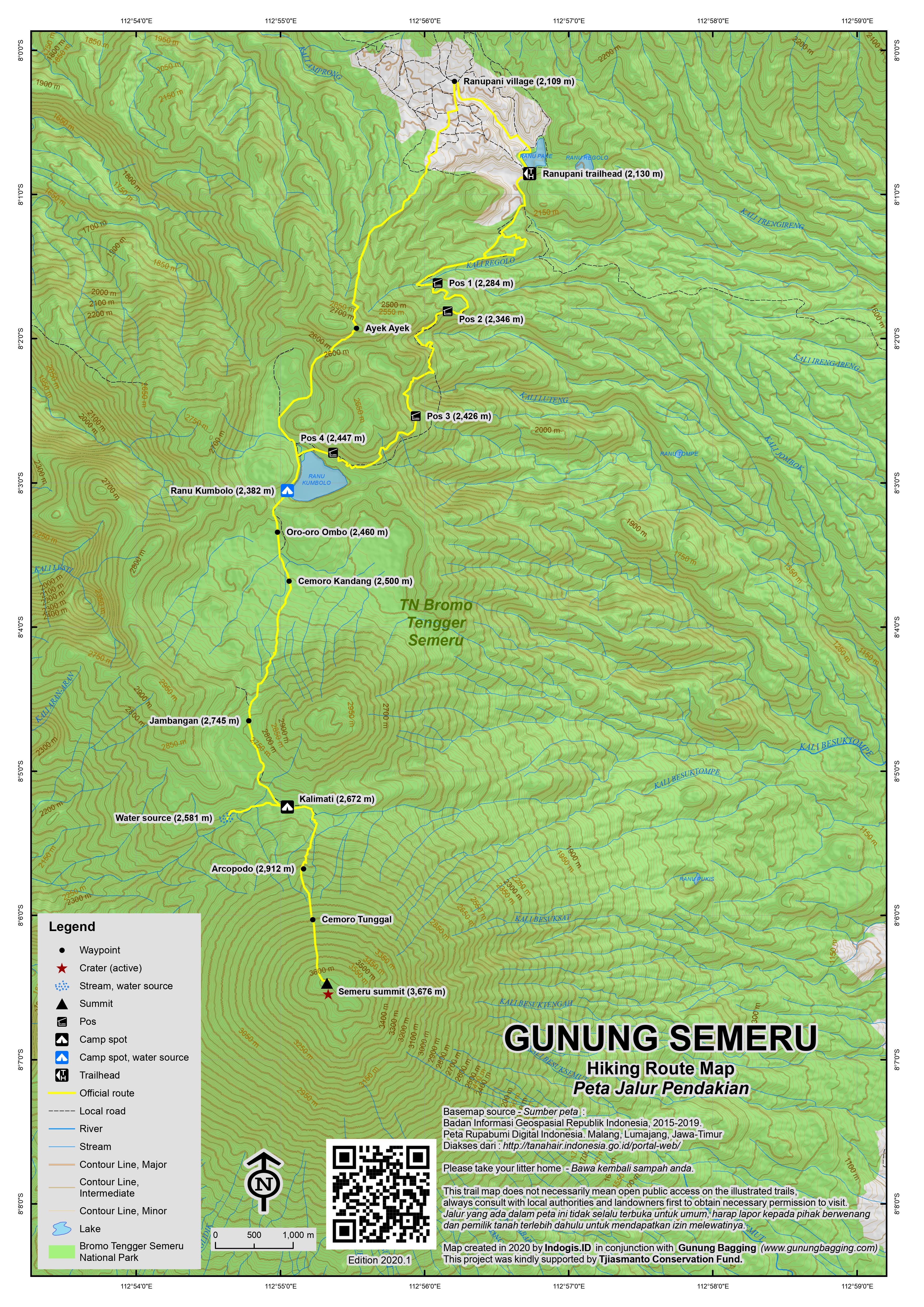
The trail starts at the village of Ranu Pani (2,109m) where there is basic accommodation available and you will need a minimum of two full days for the hike to the summit and back. The standard choice now is to spend one night at Ranu Kumbolo and a second at Kalimati before making a pre-dawn ascent to the summit, although if you are very fit and start early enough on Day 1 you can just stay at Kalimati and complete in two days total.
There are many trekking agencies in East Java who offer jeep transport across the length and breadth of the National Park including the vast Bromo caldera and to Ranu Pani village itself from the city of Malang via Tumpang. Thankfully it is not yet possible to drive to the summit of Semeru! However, the road from Malang to Ranu Pani offers breathtaking views and reaches an elevation of over 2,400m at its highest point.
From Ranu Pani follow the road towards the lake which gives the village its name and make sure you take a right just before red entrance posts (2,130m). A left turn up onto a narrow track through forest is just a couple of minutes further along and once you’re on this trail it is quite difficult to lose your way because there are frequent cement markers and green shelters at 2,284m, 2,346m and 2,426m respectively. The path is even paved at this point. Look out for monkeys in the area.
It’s a long 14km to Kalimati basecamp (2,669m) but the route goes via the beautiful Ranu Kumbolo lake (2,382m) which is a good camp spot in its own right. It can be reached in 4 hours from Ranu Pani but is famous for its low temperatures at night – frost is common so remember to take plenty of warm clothing and don’t leave your boots outside. There are a couple of huts on the far side of the lake before which the path ascends a hundred metres or so before descending again into an area which is sometimes covered in beautiful purple flowers (Oro-oro Ombo – 2,460m, followed by Cemoro Kandang (2,500m).
Kalimati (2,672m) – which lies beneath but in view of the rocky cone of Semeru summit itself – is another 3 hours of fantastic, easy hiking across savanna-esque landscapes via Pos Jambangan (2,745m) and is perhaps marginally warmer. There is a somewhat shabby hut at Kalimati and the flat area surrounding it is a very popular camping area and water is to be found about 15 minutes walk down to the right (2,581m).
The path descends a little from Kalimati before ascending steeply up the forested base of the cone of Semeru itself. Another 2 km (one hour) is Arcopodo (2,912m), which used to be the best place to camp if you intended on reaching the summit at dawn. It is no longer recognized as a camp spot so Kalimati is now the best choice for pre-summit camp in order to have the best chance of clear views and more importantly to avoid the worst of the gasses. There used to be a pair of statues at Arcopodo but it is presumed they were covered during landslides.
It is about 3 hours from Arcopodo to the summit and the track is very steep. In some places lower down there are cement posts to guide you but many of them have long since toppled over and are buried in volcanic scree! The treeline ends at 3,110 (Cemoro Tunggal) and there are excellent views particularly to Arjuna. You may also spot some pre-dawn camera flashes from the famous viewpoint Gunung Pananjakan on the northern side of the Bromo caldera. The summit cone is very slippery with small volcanic rocks – definitely a case of two steps forward and one step back.
As you near the top you may literally feel the earth move as Semeru sends another cloud of volcanic sand into the air. There are lots of monuments to people have lost their lives up here but generally speaking the climb is safe – but do not head closer to the crater itself from the summit. The view from the rooftop of Java is as incredible as you might expect – a vast panorama of all of East Java’s major peaks, something to savour before the hike back to Ranu Pani, which can be done in one long day. The first section down the scree is a lot of fun – what takes 3 hours to climb takes just 1 hour to scree-slide down!
On the way back to Ranu Pani, the more adventurous may like to try an alternative route from Ranu Kumbolo back to the village via Gunung Ajekajek / Ayek-ayek. It is a lot steeper – a 300m climb again – but marginally shorter in terms of both distance and time. If you have any energy left it makes an interesting alternative to the fairly bland plod along the normal route. Take a left turn at the lake and follow the path as it leads through lovely grassy flat landscapes before heading right up the hillside once more. After an hour you will be at the top of the pass (2,719m) which offers rarely-seen views of Semeru. Down below you in the opposite direction (north) is Ranu Pani and the Bromo caldera beyond. This now infrequently used trail used to be the main route to Semeru several decades ago.
Bagging information by Daniel Quinn.
Trail Map
For a high quality PDF version of this and other trail maps, please download from our Trail Maps page.
Practicalities
- Getting there: For domestic flights from or to East Java, such as the airports in Surabaya, Malang and Banyuwangi, we recommend Baolau. Best to arrange transport to Ranupani in advance. Malang is the closest city with an airport but there are many more flights to Surabaya (including international flights).
- Guides and GPS Tracks: Want a PDF version for your phone? Looking for a guide? Need GPS tracks and waypoints? Gunung Semeru information pack can be downloaded here.
- Trip planning assistance: Would you like Gunung Bagging to personally help you in arranging your whole trip? Please contact us here.
- Permits: Available from the homestay in Ranupani – take a photocopy of your passport photo page. You also need to present a health certificate which must include a) blood pressure and b) data for body-mass-index. Health check can usually be done in Ranu Pani but if possible get it done in advance to save time. Indonesian citizens pay Rp17,500 per day to enter the park (Rp22,500 on weekends and holidays) and foreigners including those with KITAS/KITAP who already pay local taxes pay Rp210,000 per day (Rp310,000 on weekends and holidays). Indonesian citizens must reserve their entry ticket online (limited to 600 per day). One advantage to being a foreigner is that (in 2019) you do not need to book online in advance.
- Water sources: Available at Ranu Kumbolo and near Kalimati.
- Accommodation: Try the Booking.com map above or use this link to search for suitable hotels, homestays, resorts and apartments for your trip.
- We recommend Safety Wing as travel insurance for overseas travellers and tourists hiking up to elevations not exceeding 4500 metres.
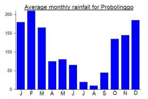
Local Average Monthly Rainfall (mm):
Location
Click on the blue arrow ![]() (top right) to see your current location on the map
(top right) to see your current location on the map
Origins and Meaning
Also known as Mahameru, meaning ‘The Great Mountain’. The name is derived from the Hindu-Buddhist mythical mountain of Meru or Sumeru, the abode of gods. (Wikipedia, 2011)
Links and References
Wikipedia English
Wikipedia Indonesia
Wikipedia. 2011. Semeru. Accessed from http://en.wikipedia.org/wiki/Semeru
A new measurement of Mount Semeru’s height from the Ministry of Energy and Mineral Resources states that its highest peak is 3,744.5 meters. Although, I can’t find out more about the actual re-measurement event.
https://pbs.twimg.com/media/GSlkTrNacAAmt3A?format=jpg&name=medium
Thanks for the comment. I am fairly confident this is an error as recent photos show the summit area as looking fairly similar to how it looked several years ago. There could be a new lava dome, but the crater is a fair way below the summit and if anything all the activity would lead to a reduction in elevation due to the collapse of the crater wall. It’s not impossible that Semeru is 3744.5m but I think it is highly unlikely. If anyone has any evidence to support 3744.5m (aside from a document) then do get in touch.
WSW of the peak of Semeru, on the cone, at an elevation of around 2950m, is apparently an old candi / temple, actually half buried in volcanic scree. There is a Google Maps marker with the name ‘Situs Umpak 9’. This could only be reached on ‘illegal’ routes up from Dampit to the southwest, possibly the same route as the obscure Limpak, a minor peak to the west of Semeru’s cone. Would be interesting to hear of any more details about this old temple that few know about.
Hi Dan, did you go to the summit on April 2022 or it’s only the date of your post ? I heard the Semeru access is closed after the eruption of December 2021, and maybe until the end of 2022. I go in Java on September and I’d like to know more about it. Thanks a lot for your help.
Xavier.
Hello Xavier. I haven’t hiked Semeru for over a decade!
Here’s the booking site: https://bookingsemeru.bromotenggersemeru.org/
I am not sure if you are allowed to the very top at the moment. It can change frequently.
https://en.tempo.co/read/1535735/mount-semeru-erupts-emitting-volcanic-ash-rains
TEMPO.CO, Jakarta – East Java’s volcano, Mount Semeru, erupted on Saturday, December 4, 2021, emitting hot avalanches and thick volcanic ash rains at around 15:00 Western Indonesia Time (WIB). Two districts in Lumajang Regencies, East Java were seen to be showered with thick volcanic rain.
A Twitter user account @pambudi_dhani uploaded a video showing the condition during the Semeru volcanic rain which could be felt until Malang Regency. In the video, the sky was seemed to be dark as if it was night time while it was only 16:00.
“Semeru volcanic ash [rain] today at 4 p.m. looks like a night time #prayforsemeru,” he tweeted.
In the video, @pambudi_dhani mentioned that his position was in Sumber Wuluh, Malang Regency. He called on the village heads in Lumajang and Malang areas to be vigilant.
Currently, Lumajang disaster mitigation agency is monitoring the situation following the volcanic eruption. A number of personnel have been set to follow up on the current condition from the impact of Mount Semeru eruption.
For those thinking of visiting Tumpak Sewu / Coban Sewu (‘a thousand waterfalls’) which lies directly south of Gunung Semeru near the road between Kepanjen and Lumajang, note that there are two different access points to two different viewpoints opposite each other – one on either side of the river – the Malang side and the Lumajang side.
Few can see the images online captured by drone here – with Gunung Semeru in the background – without putting it on their list of places to visit, and I would definitely say it’s the finest waterfall I’ve seen in Java. We stayed in one of a small number of local homestays and went down the path on the Lumajang side. It’s only a 5-minute walk to the ‘panorama’ viewpoint but you can venture further down on steep bamboo steps and ladders to explore other pools etc and make a half-day out of it.
Alas, the weather was quite misty when we were there so I doubt Semeru would have been visible even if we had been on the other side – the Malang side (west) which is where I think the photos with Semeru in them are taken.
I did this hike last month (June) and pretty much what Chromakey has written in the comments below is spot on.
I’ll list my experience below for those interested.
I rented a scooter and camp gear from Surabaya (100k per day for scooter and 50k per day for tent, sleeping bag, cooker, mattress and gas. If you type Rental Motor Surabaya into google maps he will come up. He rents scooters and camp gear.) and headed to climb Arjuno and Welirang before a rest in Malang and then onto Semeru.
I came here in 2015 but was stopped by a massive wildfire between Ranu Kumbolo and Kalimati during the Independence day so I was back to give it another go.
I got my health check in Tumpang for 15k at “Klinik An-Nisa”. If you type that into google maps it will direct you there if you need the check. I didn’t know if you could get one in Ranu Pani but it turns out right across from the registration office there is indeed a health checkup place. So you can just get it all at the registry office if you need. Don’t forget your passport photocopy aswell.
NOTE – As a foreigner, there is no need to book online. This ONLY applies to Indonesians. I just went to the office, paid my money and gave the forms and was ready after 5 minutes. The Indonesian line was about 50 people long and the foreigner line was empty.
I parked the bike in the secure, undercover parking (5k per day) and was off. It took 3 hours to Ranu Kumbolo, 2 hours to Kalimati. 3.5 hours to the summit, 40 minutes summit to Kalimati and 3 hours 30 from Kalimati back to the registration office.
There were a LOT of people on the trail. They limit the entry to 600 per day but most Indonesians spend 3-5 days in here. This means theoretically there could be more than 3000 people in there at any one time. When I came back past Ranu Kumbolo I couldn’t believe my eyes with the number of tents set up there.
The summit day was intense. I must have taken a wrong turn in the dark because I ended up 100m across from everyone once we popped out of the trees. I was glad in the end because there were just so many people going to the summit.
I got to the top at 5 am, just as the glow was coming over the horizon. I walked down to check out the remnants of an old weather station before heading over to the crater viewing area. They told me not to go more than 50m from the crater when I registered but the main summit is a good 200 or more meters away. I was the only one at the viewing platform for a good 30 minutes before heading back to the main summit. As I walked back I saw there were some rocks laid on the ground to tell you not to walk down but I didn’t take that route so missed that part. There is a small rock and a clear area where people used to view the crater so I’m not sure why it’s supposed to be off limits now. Its certainly around 50m-100m from where the small eruptions happen so according to the staff at the registration office this is fine as it’s further than 50m away.
I left the summit at 7 am, was at Kalimati by 740. Packed the tent and was back at the bike just after 11 am. As I came from Malang I didn’t realize how far the ride to Surabaya was. It took me over 5 hours to get back there. I was so tired, I’d been up since 1.30am and it wasn’t until 6 pm that I was back in the city.
This mountain is certainly very beautiful but also very tough. My GPS read 38kms in the end with 2900m of up. You have to have a decent level of fitness so you don’t get burned out or sick afterward. Especially after hiking Arjuno and Welirang the day before it was quite demanding.
Thanks for the information. My wife and I are planning a solo hike in August. As we are arriving in Surabaya, I was wondering if we could arrange transport from Surabaya directly to Ranu Pani, and vice versa when the hike is over. So far I haven’t been able to find out any information on this. Or would it be easier to make transport arrangements from Malang? Any suggestions would be appreciated 🙂
Either Malang or Surabaya should be no problem. This being Java you can arrange transport practically anywhere and any time, especially using Grab / Gocar or local car and drivers. However, you might get overcharged if you have to negotiate on the spot at an airport. Grab is a good option pricewise but I think the official Surabaya Airport policy doesn’t allow them to pick up there. Could be wrong though – difficult to keep track of it. As for Malang, compared to Surabaya it’s a more attractive place to visit in my opinion but going Surabaya – Malang – Ranu Pani is going to take a while longer than simply Surabaya to RP. Haven’t done either recently so I cannot comment on road surfaces!!!
J’ai lu ton post. Il est possible de monter sans jeep à ranu Pane ?
Hey Ryan, curious as to what you think about doing this in just one day. My girlfriend and I are experienced hikers and mountain runners so the 38km doesn’t sound too tough. Did you come across anyone doing this? Also, how about avoiding the high cost of the entrance fee? Had no problems on Rinjani doing this. Debating on paying the fee for Semeru but was disappointed in the amount of garbage in other “natural spaces” in Indonesia. Cheers.
This is a great site! Information is still pretty relevant, just that every year the opening season for Semeru changes. It is from 1st week of April for 2019.
I did a detailed blog post on my 2 trips in 2018: https://www.yonderingsoles.com/2019/04/11/semeru/
Take a look if relevant!
A buddy and I plan to hike Semeru in December (to start any day between 21 – 25 December). We are planning to do it independently without tours, so if anyone could offer any advices or wish to join us in our hike let us know!
+6597335386
Thanks for the great article and also the info in the comments!
I’m planning to hike Semeru alone in September so I’m happy to team up and hire a guide / transport.
Dates around 5th-10th September 2018
Send me an email: “tm@qoss.net”
Daniel 🙂
Back from a 2 days solo trip to Semeru.
Regarding the hike : left Ranu Pani at 10AM, was at Kalimati at 3PM including 40min lunch break at Ranu Kumbolo lake. This part is easy with very little elevation difference.
Camped at Kalimati. Left at 2:10AM, reached summit at 5:40 exactly when the sun rose. Leave maybe 30min earlier if you want to observe all the colors in the sky from the top. Quite cold and windy up there.
Started descent at 6:30, back in Kalimati at 7:30. After breakfast and packing left at 8:20, back in Ranu Kumbolo at 12:10.
Entry fees are 210’000Rp/day for foreigners but 310’000 on weekends and bank holidays so avoid those dates. Locals pay 30’000Rp per day but they have to register online at least 3 days ahead of their visit and they have a quota of 600 hikers/day. Foreigners can register directly at Ranu Pani.
Bring a copy of passeport and a health certificate (Surat Keterangan Kesehatan), can be done at local healthcare community center (Puskesmas) in Tumpang or Ranu Pani. In my case, Puskesmas in Tumpang was closed so I had to go to Boli hospital 500m away. Paid 30’000Rp and got my paper in 20min.
To get there from Malang, go first to Tumpang. Easiest solution is to use online Ojek applications (Grab or Gojek), available both ways for less than 30’000Rp. Regular ojek asks 50. Angkot available but have to change in Arjosari.
From Tumpang to Ranu Pani, local hikers usually use jeep that costs 600’000 one way for 10 people. You can try to get a seat in one but they usually optimize costs so most are full already (they go hiking with a 10 people party). Should be easier to do it on the way back after meeting people on the trail. Ojek available in front of Pasar (market) Tumpang, rate is 150’000 one way. Same rate from Ranu Pani.
Cheapest solution would be to rent a motorbike from Malang but it seems most business don’t like it. Despite what they say, the road to Ranu Pani is only slightly damaged on small portions and any motorbike can pass. Those guys have a package dedicated for Semeru hikers, 250’000 for 4 days. Contact by WA +62 899-9609-267.
Tents and other gear can be rented in Ranu Pani. In Malang check out Da Rental, for 2 days 1 2ppl tent + 1 set sleeping bag/mattress less than 60’000Rp. Brings an ID for deposit or 1’000’000Rp. Lots of stock, you can rent for longer than you need, they refund you the difference if you come back earlier.
Total costs for 1 solo hiker (logistics, park fee + transport) 2 days start Malang : 958’000IDR.
Thank you for this article!
Is it possible to come to Ranu Pani on a scooter?
Greeting
Alexander
Can anyone that has hired a guide, independantly from tour companies etc… please advise the daily cost ?…..and if anyone has used a porter ?…..how much ?…..I know lazy, but kids and myself with bad back…not bad to hike, but cannot harry a pack after time, especially with some weight in it…cold clothes, camera equip etc. Thanks……..oh and if any recent contact numbers/emails etc.
how is the weather for end Dec or mid Feb as I intend to hike but I’m a solo hiker…..
if theres’s any group going, i’m happy to join in.
Look at the rainfall chart. Dec to March worst time of year in Java and trail quite likely to be closed….
just to review..
i and my team hike semeru on 15th Sept, thats cool and awesome mountain, we could saw amazing view, especialy my favorite camp site ranu kumbolo lake. thats so amazing and Super camp. but wheather is so cold at ranukumbolo..
Thanks to Gunung Bagging for itinerary and review. Big Thanks to Mr.Budi (budiguide55@gmail.com) as guide and experience trip, Mr.Budi is local guide, he lives at Ranupani village..
Thanks GUNUNG BAGGING and DAN..
best regards,
Martens
Hi, we are 2 persons, plan to hike on 18 sept. We are looking for hiking buddies since we heard that we can only hike with min 3 persons. Let us know if we can team up? And do you know where can we rent a tent?
Julian +6281398661321
Mate, I hike it alone. Two people are fine.
Can anyone recommend local guides out of ranu pani for two or three day semeru trip this week?
hi jono, here’s the whatsapp number of recommended semeru local guide, he has been there more than 20 times, you can ask him, +6285233332317
Hey world, just to provide report from my trip to Mahemeru in September. I connected with local guide Yayan in Malang, he was very helpful in organising everything for my trip. Take note that you do need the medical certificate to enter the park and formal documents will be completed in Ranu Pani before entering. Beautiful food in Ranu Pani warungs before setting off for two days one night trekking with puncak sunrise. This itinerary is manageable if you are very fit but i feel two nights on the mountain is a better schedule.
If you wish to approach the climb via Malang, I recommend Yayan as a guide, he speaks great english if your a foreigner like myself. He is very helpful and knowledgable, knows the mountain very well and even some alternate routes that we followed on our return trip.
Yayan – +6285233332317
How is the start till to summit the common program or we can do 3 days hike totally start to the end
I am planning to do it in 3 days the first weekend of September. It is 2 of us at the moment, but it’s open for more if you are interested.
Hi Paulina, how did you get on with the climb. I am looking to climb tomorrow.
Hi Paulina
We, 2 persons, plan to hike on 18 sept. We are looking for hiking buddies since we heard that we can only hike with min 3 persons. Let us know if we can team up? And do you know where can we rent a tent?
Julian +6281398661321
I hiked Semeru first time on 2014. That time I said to myself.. I would never come back again.. to many indescribable mystical journey that we passed and found along the way that really made me speechless until now.
Semeru is a very unique mountain, I would never find in any other part of the world.
In fact, a year later on 2015, friend of us went hike Semeru again, and he was reported missing for 3 days when he descent after summit push, he got lost @ Blank 75 for 3 days. Lucky he survived and found alive by Search & Rescue with scars, swelling, wound and bleeding all over his body.
All of us in Jakarta who could not go and join the rescue, were crying like a hell.
thanks God he’s alive. After I remember I visited him in hospital in Bogor, I was crying but we still talked joke “Hey buddy, let’s go back to Semeru again one day”
Just recently early this May 2017 I went back to Semeru and bring my clients to hike there. Still speechless to see every slope, corner, tree and so on.
But yeah.. It is beautiful… it is also unspoken.. I love Semeru
Hi,
I intend to hike Semeru with a group of friends next september.I was looking on internet for Semeru/Bromo with transport from Surabaya. Price seems expensive (around 3,500,000 IDR).
We are looking for a guide at reasonnable price.
if Anyone have some information. thanks
Best
Marc
marc, usually the 4days trip cost around 1 mio for group of local group(15-20) with pick up from Malang.. Not so sure if the price for foreigner is the same.. we plan to go there end of sept or early oct. If you have email, we’ll give you update if we have some space.
Mark, what are your dates?
Hi marc i also plan to go there this september. Please contact me via WA : 62 815511 2092
LINE: sheilaprawoto
hei marc got your guide already? i have some lists of recommended guide. whatsapp me on +6285855100021
Agustus mbk nia naik lagi
Okay this has been pending for a while but I’m here now and shall pay my due diligence with a trip report.
First of all, Semeru is a world class hike from every aspect, with a reward that is tough to beat once you’re at the top. Live eruptions every 10-15 minutes and a chance to witness mother nature at its powerful best.
Started off from Malang (Flights, buses and trains available from most major cities in Java) and got my health certificate at a local ‘puskesmas’ for Rp 5.000. Jumped on an angkot with the letter A and found myself in Tumpang around 30 minutes later. Angkots are aplenty from Arjosari bus terminal. Ojeks can take you to the nearest puskesmas for roughly Rp 20.000 (and that is being generous).
From tumpang, several options including ojek, pickup trucks and shared jeeps (best option IMO) which cost Rp 55.000 per person upto 12 people. A 2 hour drive later we founs ourselves at Ranu pane basecamp. You can stock up supplies at Tumpang itself next to the jeep rental. Everytjing from rice, noodles, vegetables and meat to fast foods, peanuts, snacks, fitbars and whatever else you may need are all there thanks to the local market and the adjacent indomaret and alfa marts.
At Ranu pane you will be briefed by the local caretakers on safety, etc. Do not come with the intention of scribbling on the rocks on the volcano, any knives and dangerous objects will be confiscated and returned upon your return from your hike. Each individual’s bag will be checked for supplies. Those not carrying enough supplies and proper attire will be denied entry. Basically, just prepare well. All rubbish will be accounted for, which means that the number of food packets taken with you should equal to the number of food packet plastics in your possession upon your return. Failure to bring back your rubbish will result in another hike back up the mountain to collect your rubbish. No fires allowed to be made hence it wouldn’t help to say that you burned them to make a fire (I had my doubts regarding how strict they were in their checking as they checked my rubbish bags but let a couple of others go without checking theirs). Nevertheless, better safe than sorry. They do not mess around with their safety instructions as there have been an overwhelming number of deaths on the volcano in recent times. Do listen to what they have to say.
Now, the hike itself was beautiful. Straightforward, no confusion, gentle inclines and declines to complemens. Three official pos’ until ranu kumbolo, followed by 2 more from ranu kumbolo to kalimati. Arcopodo pos does not exist anymore and all camps have to be made at kalimati prior to the midnight climb to the top.
The climb from Kalimati to the top of Semeru was not the most difficult one (The final climb in Rinjani was a bit more challenging), but this does not mean that one should take it lightly. Do prepare for the climb really well in terms of physical fitness as you will need it. Core strength and glutes/leg strength especially. Heaps of a mix of high intensity cardio and long, sustained cardio will help too.
15 people took off with me from Kalimati that night and 12 of us made it to the top. Three of us made it to the top in around 4.5 hours (bagged the peak at 4.15am) while the rest arrived well after sunrise (7am onwards). Due to our early arrival at the summit, the 3 of us could witness lava spurting out of the volcano before the sky turned bright. Truly incredible indeed.
Take some great pictures (keep the cameras ready for the loud booming noise before an eruption and roll the camera immediately to get the best videos/pictures of the live eruptions. Weather was perfect, clear skies and multiple peaks can be seen in the distance on all sides. Arjuno-welirang and argopuro in the west all the way up to majestic Raung in the east and Bromo in the north.
“Volcano scree run” you way back down before 9am as the wind tends to blow the toxic fumes from the volcano towards the hiker. Do not, i repeat, DO NOT get close to the active crater. More people have died than made it back alive. The volcano is highly unpredictable and can erupt in periods of 5 seconds up to 15 minutes. There is no pattern for the eruptions.
Pro Tip: in order to lighten the load on your backpack, carry food enough until the climb up and back down to kalimati. There is a 24×7 warung at ranu pane available which serves you the best food and a lot of coffee. Slightly more expensive than what you would get in the city but nothing outrageous. A good 50.000 should be enough food for 3 meals. Water is expensive though (Rp 10.000 for regular aqua and Rp 25.000 for the big bottle).
Fresh fruit also available immediately after Oro-oro ombo. The watermelons are to DIE for!
The climb back down is gentle as well. Nothing dramatic. Alternative climbing route from ranu kumbolo to ranu pane available (used by porters and a fair climb up a hill before descending down to ranu pane). Do not attempt unless you are sure which hill to climb for the alternate route.
Warungs/tea-coffee/gift shops/accommodation all available at ranu pane. Go back to malang the same way you got there. Basecamp can arrange for transport.
For foreigners, Rp 55.000 is the price per person for 12 people on the jeep. Please be aware in case they try to con you like they tried to con me. Luckily, my Indonesian was a lot better than they thought abd managed to dodge an unnecessary payment.
Another tip, do carry sunblock for certain parts of the hike and please carry a large face towel as well to cover your mouth and nose as the track could be dusty if it hasn’t rained for a while and irritating to the eyes, nose and mouth.
Its gets as cold as zero to 4 degrees and night. All of that is absilutely true. Please carry appropriate clothing as you will definitely need them.
Other than that, enjoy one of the most rewarding climbs not just in Indonesian but in the whole world. Second best climb for me after Tambora.
Safe travels and good luck!
PS. entry for locals/KITAS/KITAP holders (Rp 17.500-25.000)
Entry for foreigners (local price x 10). It sucks but unfortunately thats how Indonesia works. If you ask me, it is worth every penny of the foreigner’s entry ticket. Don’t miss this one if you’re contemplating doing this one.
Cheers,
GG (Gaurav)
I just bagged Semeru between 5-7th December 2015. Kudos to those who can do it in just two days. Took me 4 houres the ascent from the tree line. Sunrise starts at 4.30 am in Jawa. Got on top half hour later but still in time.
Did it on my own, no porters, no guide.
In my opinion best to approach Ranu Pani from Malang. There is straight train to Malang from either Jakarta or Jogja. I did Malang-Ranu Pani on automatic scooter. Took me aprox 3 houres but I am not the most experienced driver and last 2 km or so of road is really broken.
If you want to reach Ranu Pani by public transport take “angkot to the Arjosari bus terminal. Luckily for you angkots travelling to Arjosari pass most main roads in town frequently from early in the morning to late at night. Look for any angkot with the letter A on the windscreen — such as an ADL or GA. Once at Arjosari, catch an angkot to Tumpang, 24 kilometres away.” (Source info: travelfish.org)
In Tumpang you either take an ojek (motor taxi), join others in renting a jeep or a truck (cheapest option). Also in Tumpang you can solve your health certificate at the local hospital. I payed 25 000 idr on it. Everything went smooth. Bought the materai (stamp) at the post office.
If you want to do it with a guide I would recommend Nanang Sunarko (hiddenindonesia@gmail.com; +62 812 3164 7733). Met Nanang at the Ranu Kumbolo basecamp. Perfect English and one of the most interesting Indonesian persons I met so far. Had the chance also to taste his cooking. Enak sekali! Just search on youtube “hidden Indonesia Semeru” to get an idea about him.
Also if you want you can reach the Sea of Sand of Bromo by foot or motor (road still in repairing at this moment though) unless Bromo is nauthy and puffing. The road in the savanna looking like landscape starts some kilometers before Ranu Pani.
Once again we have done the climb to Mt.Semeru precisely on September 2015 and thank you very much to Parningotan Sinambela as Ranger Officer in Ranu Pani, Lumajang who has helped and arranged our trip in Mt.Semeru.
Regards,
ONY TJAHJONO
Doha, State of Qatar
We climbed this peak in two days via Ranu Pani. We contacted a guide that I had climbed with frequently and he suggested a 3 day itinerary which upon review was too much time.
You can do Ranu Pani-Kalimati in just around 5.5 hours, assuming that you are in reasonable shape and have some experience with mountains in Indonesia. There isn’t much elevation gain at all between the start point, with the major elevation drop happening when you descend maybe 75 meters to the Ranu Kumbolo lake and then ascend again on the way to Kalimati.
You could even push further past Kalimati and camp right below the rocky scree area of Semeru. That might save you 45 minutes in the morning of your summit attack.
Our agenda went as such:
DAY 1
8.30 begin
12pm arrive Ranu Kumbolo
12-12.30pm Break for lunch
12.30 – 230pm arrive Kalimati
chill out, dinner, early to bed
DAY 2
2.30am depart from Kalimati
6am arrive Summit (again, you can cut some time by camping a bit further up in the forest area closer to the scree)
6.45am depart Summit
730am down to Kalimati
9am depart Kalimati
2pm arrive back in Ranu Pani
I should add the caveat that the above is based on your being reasonably used to Indonesian gunung2. We brought most of our own gear on our backs and only had porters bring our tents and to show the way. As expected you should be prepared for variable levels of experience (and fitness) amongst your guides and porters. We definitely outpaced them back and forth between Kalimati, and none of them made the summit in time whereas all of our party did. Not their day I suppose.
One thing that was helpful from the guides is that they brought helmets, which provided a nice sense of security while ascending the rocky scree. It’s not essential, but there is the potential for something bad to happen from the loose rocks caused by climbers ahead of you on the trail.
Interestingly, your post is the only one that mentioned helmets. I understand that it was required at some point in the past. Do you know if they are still needed? May I have the contact of your guide for me to check? I am heading to Semeru this June 16-17.
I’m arriving Surabaya at 10am on a Wednesday morning. What is the fastest way to Ranu Pani from Surabaya airport? via Malang or Cemoro Lawang?
Thanks!
I’ve heard from the news the summit is closed for the moment. does any one know when it’ll open again?
http://www.thejakartapost.com/news/2015/08/14/mt-semeru-s-climbing-trail-reopened.html
Today I and colleagues from Malaysia to Ranu Pane and will climb Semeru morning.
Best Regards
#dukun_gunung71
Hi all,
Going to hike Semeru alone within two days in mid-August.
I’m going to travel from Ceromo Lawang to Ranupane.
After a morning in Ceromo Lawang, my plan is commence hike about 12pm and within 6 hours reach Kalimati or Arcopodo. Nap then hit the summit and hike all the way back to Ranupane the next day.
Does anyone know if I can rent a tent, sleeping bag and mat at Ranupane? How much roughly should i be expected to pay?
Hi Sean,
I just came back from Semeru in June 2015 with a group of friends. We rented our gear in Cemoro Lawang from a tour organizer – to rent a tent and sleeping bag would technically cost you less than 200k IDR if you manage to find someone who’d rent it to you ‘a la carte’. I struggled to get things separately so eventually settled for a deal of 1.1 mil IDR per person which included airport transfer from/to Surabaya, Jeep transport to/from Cemoro Lawang and to Ranu Pane, 2x porters and climbing permits. Our rental didn’t include sleeping mat – just tent and sleeping bag.
I’m interested to know if someone comes up with any contact that allows you to rent these items there.
Hope this helps.
Cheers,
Jade
**
A side note: Nobody asked to see the climbing permits or the medical certificates, but good to have ‘just in case’ anything happens. The insurance might refuse to pay if you didn’t take the “necessary precaution”. It’s really up to you.
Thanks Jade. I’m stopping at Ceromo Lawang so will try there otherwise heard I can pick these up at Ranu Pane.
Hey! Just wondering which tour/guide you went with and was it good and trustworthy?
Accomplished my goal of climbing Semeru over a long weekend. (August 8/9 2015)
Landed in Surabaya and got the Damri bus to bus terminal where I boarded a local bus to Probolinggo. Annoyingly waited an hour for a minivan which grouped together about 8 foreign tourists for trip to Ceromo Lawang. Was cheap but going private would be way less hassle.
Had very basic accomodation at Yog Bromo and woke at 4am to see the sunrise from Penenjakin. It’s an easy walk walk to a good vantage point had my head lamp but could have gone without. Walked back for back to village for one of the best Omelettes I’ve ever eaten – so fresh. i then got an Ojek at about 9am to Ranu pane via the Bromo caldera. Stopped at crater and other points of interest.
At Ranu pane, registered and hired a tent and sleeping bag (100,000 rupiah for both for two days). Mats seemed so thin I didn’t bother for the extra weight. Started hike at about 11.30am to 12pm and reached Kalimati at about 5.30/6pm. I stopped at the Ranu Kumbolo for a 30 min nap and had some rest stops as wasn’t used to carrying such a load a long way. It’s a long walk, not too steep but gradually inclines. There were loads of locals all of whom wanted to say hello and where I was from etc. They thought it strange I was going alone.
I actually wanted to camp at Arcopodo but decided it wasn’t worth carrying the weight up there and wanted a light pack for the summit attempt from Kalimati. So dropped my tent there and was thankful some locals help me pitch my tent.
After a cold sleep I woke about 2.30am which was later than I wanted. I left my head lamp in my bag at Ranupane and phone was low on battery which i wanted to save for pics so walked up from Kalimati in the dark. I took a wrong turn from the actual path but didn’t know it until descending. I ended up fighting much more volcanic scree than I needed to but my path may have had more moon light than actual track as i was hiking in the dark. Once above tree line saw loads of lights from Indonesian hikers. Eventually found the path and it was hard graft but I passed load of locals so they were finding harder. Slow and steady I made my way to the peak a bit after 6am and a bit after sunrise…but I was still chuffed! It was super windy and freezing. Stayed for 20 mins and headed down. Was actually hoping for more volcanic activity but saw one puff of smoke on the way up. I was going to walk to the crater – looked easy, but it was so windy and dust was blowing in my face. Decided to just enjoy the peak. I pretty much ran/slid down the scree to Kalimati. Rested and then it’s a long long walk out.
I was so tired and wanted a decent sleep so I got an Ojek from Ranupane to Malang (i think I got ripped off on the price but didn’t care) and stayed in a nice hotel for the night.
I climbed Semeru two weeks ago. It is one of the best climbes you can get on Java. My hiking time: from Ranu pane to Ranu Kumbolo 2:45 h (with only two very short breaks), from Ranu Kumbolo to Kalimati 2 hours (with two longer breaks), from Kalimati to Arcopodo 35 minutes. I camped in Arcopodo, which is higher than the 2912 m that are mentioned in the text! I stayed on the place where the old now corroded sign can be found and it is around 2960m. From there to the summit you need around 2:30 h at a slow, but steady speed. The water source at Kalimati was available. The way back to Ranu Pane is long and a bit borring after having hiked the same way the day before.
By the way, I was not asked for a medical certificate.
It is a great hike.If you like mountains and you are in Indonesia, it is nearly a must to go to Semeru. A guide is absolutely unnecessary. The trail is very good and the indications are much better than in the rest of Indonesia. Accomodations in Ranu Pane are quite basic, but I found a reasonable one.
Hi Matthias. I plan to hike Semeru this October. Would you be willing to share your recommendation on affordable guide. Many online companies (including the local ones) charge quite expensively (IDR 3-4 million per pax). Thank You
GPS track of western approach from Ranu Pani to Ranu Kumbolo lake and new trail from Kalimati to summit: http://gaziga.com/semeru/semeru.kml
Track to water source from Kalimati basecamp: http://gaziga.com/semeru/kalimati-water.kml
Photos and report in my blog (in russian): http://gaziga.com/semeru/
Feel free to comment and ask any questions
Mt.Semeru is a beautiful mountain in East-java, Indonesia that it has many beautiful views such as Ranu Kumbolo lake, Oro Oro Ombo the savannah area so we don’t get bored on many times climbed it. And thank you so much to Mr. Parningotan Sinambela who always helps us in the ascent of Mt. Semeru.
Regards,
ONY TJAHJONO
Doha, State of Qatar
wew, semeru is the highest mountain on the island of Java
Tari from Ranupani can be reached at 0821 418 593 74. Two expat friends hiked G Semeru with him, he charged the same as he charged locals.
Can anyone recommend a good guide/porter for Mt Semeru that will charge real locals price. We live in Bali, 2 people
Thanks,
Micheal
A motorbike ride to Ranu Pani should be fine. However, climbing alone is not advised. We have the account of the American who was lost on the mountain for 48 hours.http://budihermanto.blogdetik.com/2010/09/12/an-american-mountaineer-was-found-safe-on-semeru/… Semeru is a mysterious mountain, before I climbed it, I had some incredibly powerful and lucid dreams. Hiring a guide is advised. Look up Jarodi Hestu on the equatorindonesia.com website, he climbed it many times and knows the locals and won’t overcharge you. Zac
Hi All,
Thank you to everyone for sharing their experiences! This is stuff you can’t find in a guidebook!
I’m doing a solo motorbike trip around Java in December and would like to climb Mt Semeru while I’m in the area.
I was wondering if the road conditions make possible to ride a motorbike from Malang to Ranu Pani, solo? I’m an experienced rider. I was also wondering if it’s possible to hire camping gear, including an overnight backpack, from Ranu Panu? As I’ll be riding a motorbike for 12 days, I’m not bringing much luggage on this trip.
I intend to do the climb in 2days/1night. Also, would you advise on getting a guide from Ranu Pani, or should do it alone. I am also a relatively experienced hiker.
Any help or advice would be greatly appreciated!
Alan
Hi Alan,
check the website of Rani tours in Malang http://rani-adventure.com/. They are excellent and may assist you with anything you need, at a fair price.
Wolfgang
Hi Alan,
Everything you need is already available in Ranu Pane. The road access from the gates of Cemoro Lawang closed Total as Making New Roads until Dec 15,2015
Best Regards
Dukun gunung ****
Hey all!
I just climbed to Mahameru in August 2013. This has become a hugely popular destination now, as a movie called “5 cm” came out in December 2012, about 5 Indonesian friends who climb Mahameru. I was there in August 17th, 2013, and there were at least 500 people climbing to the peak. To the point of where there was a queue (a line) to get to the top. So if you don’t want a touristy experience, be aware of when you are going. Avoid any time that Indonesians have a long weekend or a national holiday. Mahameru will likely be very crowded. However, other times of the year it is not that crowed at all. My Indonesian friend said that he’s been there when there were only 6 other tents. The weekend I went, there were hundreds.
It took me 5 hours from the treeline to the peak. I’m a pretty fit 24 year old and I kept a steady pace. I was only slowed down maybe an hour maximum by waiting in line. So prepare for a long-haul hike to the top.
It’s freezing, too. Wear layers. Bring water and snacks. Wear gloves to grab onto rocks/sand to help pull you up. Wear warm socks or something that cover the tops of your shoes and pants so that rocks won’t slide into your pants on the way down. If you have any questions, don’t hesitate to email me. I’m a Peace Corps volunteer living in East Java until June 2014, so I like to think I’m pretty well-informed about what is going on here!
Sarah
Normally people ride a city car from Surabaya to Tumpang then a jeep or truck from Tumpang to Ranupani. Riding a jeep from Surabaya takes more time and is less comfortable. Pak Laman in Tumpang can arrange both options, he is at 0813 349 504 54. Otherwise Bonie in Malang (0816 429 6849) can also arrange it. In Surabaya you can rent a good car from Bing (0812 310 7072). You can then continue to Ranupani on pak Laman’s jeep or truck. All of them are trustworthy and reliable. Surabaya to Tumpang is 2 hours and Tumpang to Ranupani 1.5 hours. Tumpang is a good place to buy your logistics.
I will be flying into Surabaya. My group will have at least 3 persons so we are thinking of hiring a jeep. Anyone know of good jeep drivers that I can hire to drive from Surabaya to Ranupani? How long is the duration?
Tari (living in Ranupani) is a good guide but does not really understand english, and he is a relative of the Ranupani office head. His number is 0828 393 7514. Alternatively, an english speaking guide from Malang is Bonny 0816 429 6849. He knows every mountain in Java and other islands.
Regarding the health certificate…would they accept one from another country (i.e. the US)?
when i climbed semeru i got a health cert from a doctor in singapore and that was ok.shouldnt be a problem.
HI. Whcich guide did you take for the climb (any contact details). I plan to climb Semeru in April 2013 in 4 days?
cheers
Greg
Ranupani to Ranukumbala (the lake), be really careful when hiking in the night as the path near the ruined shelter (Shelter 4?) confuses you. Easily could lead you to the lake shore. Find the ruined shelter and keep right.
At Kalimati, get water at the Sumbermani water spring some hundred meters or 10 minutes to the west. The path is along a sandy dry trench with a spooky air. There are 2 springs, 1 small and the other (a little further) pours plenty of water down a wet green cliff.
Kalimati is nice to camp in because of the shelter but you better camp at Arcapada and save 1 hour of steep ascent.
Sometimes you come across a deer hunter with his dogs smeared with deer blood. They hunt at the hills and savanna beyond Ranukumbala.
Notes from an ascent in August 2012.
First, some bureaucracy. I paid Rp5,000 for a health certificate from a puskesmas (government health clinic) about 5 minutes walk from the bus terminal in Tumpang. In Ranu Pani I presented a photocopy of this certificate plus a passport photocopy at the park office and paid Rp74,500 for bits of paper, comprising entry ticket, climbing permit, insurance and international camera (that’s foreign owner, not foreign camera!). (Funnily enough, the Rp50,000 camera ticket was not in my stapled envelope of documents until I checked and insisted on receiving the bit of paper I had paid for.) I also bought a Rp6,000 tax stamp for a signed disclaimer, saying I accepted all responsibility for any risks from climbing beyond Kalimati. Although the official notices seem to discourage going up to the summit, guides and porters readily understand that many people want to go all the way to the top. There were about a dozen would-be summiteers on the day I went up, so the summit will probably not be off-limits, as long as the volcano remains relatively quiet.
It seems very straightforward to find guides and porters on arrival in Ranu Pani. My guide Asmadi was introduced to me by the jeep driver and proved thoroughly professional.
Unless you especially enjoy cold nights in tents, a two day one night trek is quite sufficient. We took only seven hours, with leisurely stops, for the first day from Ranu Pani to Arcopodo, and much of the trail is flat, so nobody will go significantly slower.
In contrast, Dan’s “three hours” for the second day ascent of the volcanic cone from Arcopodo to the summit is only for the strong. I took four hours, clambering many stretches on all fours, digging fingers into the gravel (poles could have helped!). Some people were still struggling up the lower part of the cone, and in danger of flouting the “no summit after 10 a.m. rule”, when I was coming down at 7 a.m. Start out at a time that suits your fitness level; it is easy to slow down, but very hard to speed up!
Pak Tumari’s homestay in Ranu Pani is a fine place to stay before or after the hike, with simple, satisfying meals.
Dear Sir,
Could you help me information detail of Mahameru wether still open this year for trekking, could you recommend good qualification local guide, name and mobile number please,
My self doing trekking for Bali area
and interessted to try Mahameru.
Thank you for your kind help.
Best Regards,
Mudi
Hi Mudi
Please look on our guides page (under ‘resources’) and search for ‘S’ for Semeru. There you will find 2 or 3 guides and HP numbers…
i’ve climbed semeru on 2-7 september ago spent 3 night there. It was a long trek (17 km from ranu pane to mahameru) with dusty and sun brightly shine over us. For me that rarely doing excercise, it was a hard trekking. But we could saw amazing view, especialy my favorite camp site ranu kumbolo lake. The hardest part when climbed to mahameru. it’s take more than 4 hours to reach the summit, but less than 1 hours back to arcopodo. the track is consist of volcanic sand that steep uphill path. Overall it’s was an amazing & unforgetable journey there.
Some extra detailed info courtesy of Teddy and Juri…
The description of the trail itself is quite accurate, so here – only some details on the approaching part. Tumpang, the obvious starting point, is connected by angkot from Malang’s bus station Arjosari (18km – 6000 Rp). Ojeks from Tumpang to Ranu Pani cost 70 000 Rp, according to all indonesian hikers. Being with a group creates the option of hiring a jeep for 420-450 000 Rp (in Tumpang), which was shared by 14 persons on the way down in our case. The hard way to do it is to wait for an angkot to fill up (at Tumpang terminal) for the final 12 km to Gubugklakah (5000 Rp), from where there are still 18 km to go (on a very bumpy road, managable only by a robust vehicle with high-clearance). Saturdays and Sundays are perfect for getting a lift from the hordes of locals, on their way to Bromo and there are about 5 km from Bromo junction to Ranu Pani visitor’s centre trailhead. Beware of overcharging at the office – we were cited 30 000 Rp insted of the correct 24 500 Rp per (foreign) person. The area above Arcopodo was officialy closed (cited on 12.06.2011 at the reception), as considered by the crater activity. There were reports of a loud explosion, heard at Ranu Kumbolu previous night, but none of the local hikers seemed to care. Some small explosions of sulphur and ashes started at summit time (05:00) and continued until 08:00 – clearly visible from Kalimati.
## The area above Arcopodo was officialy closed. ##
But are there any trekker that still try to reach the summit ?
I will travel there in August, Mt.Semeru’s summit is my reason to travel there.
So I want to know despite the warning, Some Hikers still go to summit, or nobody?
We climbed to the summit only two weeks ago – there were lots of people hiking. There was some concern over the last month that Semeru’s activity could indicate a larger eruption might happen, but Semeru and nearby Bromo are both open. There were numerous minor eruptions from Semeru while we were in the area and ash falls the evening we climbed. When at the summit, do not under any circumstances go near the active crater. It’s a magnificent mountain area – read my blog post at http://www.deangeomatics.com/blog
Interesting comment from Wolfgang….
Hi Dan,
reviewing new and older fotos of Semeru I just wanted to bring to your attention the fact that now – in contrast to earlier years – the trail to the peak of Semeru is very visible from the valley. That is obviously a consequence of the lack of emission of solid particles (dust, sand,stones) in recent months, so that the trail is not blanketed several times a day, as in all the years before.
Regarding the health certificate, as far as i know, it’s derived from a good phylosophy of “self respect and responsible trekking” principal. Regardless the issue of BMI, i personally would say that this certificate is more to be a proof that you are able to climb the mountain, and not pushing yourself to climb the summit, based on general health standard (including blood pressure). This certificate can either be optained from a doctor or health center in your neighborhood or in Tumpang. However, if you haven’t had yet until your d-day, you can get it easily in Tumpang, for 10.000 rupiah in cost. It’s easy, and no need to worry 🙂
two days ago I went to Semeru ..I met Mr. Wolfgang Piecha and we got the sweaty Mahameru together.
Hello Mr. Wolfg.. I wait the amazing picture of Mahameru…
Hi Eko,
of course I have some great pics of you on top of Mahameru! Send me your mail address to “wolfgangpiecha@yahoo.de”
Wolfgang
okay.. what next trip?
Update from a friend regarding what you now need in order to climb Semeru…a rather annoying administrative addition…
“as more trekkers died from heartattacks (three in recent 18 months) than from eruptions, there was introduced a new government requirement for a health certificate for everybody, which must include a) blood pressure and b) data for body-mass-index. I got it quickly and cheap in Tumpang. It has to be presented together with the passport copy.”
Can you give me some more info on this health certificate? Will they refuse the permit if the BMI is too high? Bring a certificate from a doctor from home or get one where in Tumpang?
Thanks for your help.
I talked to many people, including students, and to tour organizers on Semreu and in Tumpang. The health certificate is a must. I don’t think they are too strict on excluding people, as I have seen some people that clearly were overweight. More important than BMI seems to identify people with blood pressure problems. I got my certificate in Tumpang, within five minutes. My tour organizer did not charge me extra.
Semeru.. lifetime memories..!!
I’ve climbed it 16 years ago when I was a teenager. 3D/2N climbing. I always missing every moment there..
Semeru, hope someday I can get back to your lovely places.
The first mountain i climbed .. ever!!! It was a very amazing experience. There’s no doubt, when you do the hiking, you won’t get tired coz the views are Great! I certainly would love to get back climbing this amazing mountain!
I got many memories there, including camping in a -5 Degrees Celcius at Ranu Kumbolo! Superb! hehehe
Semeru, you will always be in my heart!
I just made the summit to this mountain a few weeks ago.By now semeru is well known all over the world as a world class destination for adventure seekers. It is truley an awe inspiring experience seeing Semeru from different vantage points.Ranu Pani,Kumbolo lake as well as Kali Mati and Arcopogo just below the treeline where the ash meets. For a veteran climber it should take no less than 2 days to get to the summit and one day to get back. If you are abegginner consider the 3 nights 4 days trek as it gives you a wonderful oppurtunity experience the highlands of east Java as well as the jungle.The mountain demands respect, and can stir up some unpredictable conditions.Bring lots of warm clothes. I heard it was the coldest place on Java. The drive there is one of the scariest parts so take your time. Enjoy.It is an incredible trek.
Excuse me?The drive wot do u meang is one of the scariest part?Thanks