
Facts
- Elevation: 1,135 m (3,724 ft)
- Prominence: 1,135 m
- Ribu category:
 Kurang Tinggi
 - Province:
 Maluku Utara (North Moluccas)
 - Island: Mangoli
- Coordinates: -1.8318, 126.0525
- Rating:
 (Bagged it? Be the first to rate it)
 Loading...
 - Other names: ‘Gunung Loko’ on the Bakosurtanal map.
- World Ribus ID: 69161
Bagging It!
This peak is the highest point on the island of Mangoli/Mangole. The Bakosurtanal map lists the peak as 1,135m high and spelt ‘Loko’.
Practicalities
-
- Getting there: Unknown
- Accommodation: Unknown
- Permits: Unknown
- Water sources: Unknown
Local Average Monthly Rainfall (mm): 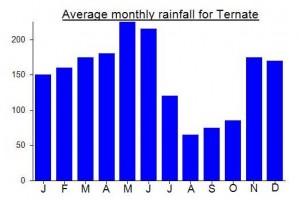
Location
Click on the blue arrow ![]() (top right) to see your current location on the map
(top right) to see your current location on the map