
Facts
- Elevation: 2,683 m (8,802 ft)
- Prominence: 2,683 m
- Ribu category:
 Tinggi Sedang
 - Province:
 Maluku (Moluccas)
 - Island: Buru
- Coordinates: -3.3006, 126.2199
- Rating:
- Other names: Kaplamada, Kapalamadan, Kepala Madan
- World Ribus ID: 69018
Photos

Bagging It!
This Ribu is the highest point of Buru island. Almost certainly not climbed in recent decades. The name may even be incorrect – there is another high peak called Kakudgehan according to a local hiker from the region. Without doubt, a look at the relevant Bakosurtanal map would be highly beneficial for anyone thinking of attempting it. There appear to be animal tracks high up the mountainside (based on Google Earth satellite imagery), presumably wild pig. This is one of the most significant mysterious peaks in Indonesia outside of Papua.
Practicalities
-
- Getting there: Wings currently fly there from Ambon.
- Permits: Unknown – take a photocopy of your passport photo page just incase.
- Water sources: Unknown
Local Average Monthly Rainfall (mm): 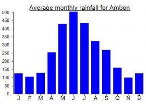
Location
Click on the blue arrow  (top right) to see your current location on the map
The first team to summit were from Pattimura University in 2022, followed by Wanadri Expedition last year (it took them 28 days in total). I went up with Kanal Buru in April 2026 and reached the summit of Kapalatmada – really tough hike, took 15 days – but we were lucky in having rain shortly before (and during!) – after a period of dry weather (such as now) there are no water sources at all after around 800 m – which is four days hike from the summit.
Hi James. Thanks for the comment – very impressive. It’s great to have more first-hand information on Kapalatmada.
No worries, Dan. We’re writing up an article about our trek, as it was for birdwatching. It’ll be published in December so can send a pdf of it then, will contain photos, info etc.
On October 10, 2025, the summit of Puncak Kaku Ghegan, the highest point of Mount Kapalatmada, was successfully reached after 20 days of trekking and opening a new hiking route.
This marks the first documented ascent in recent years, and possibly in history ..
The expedition team consisted of:
– 6 members from Wanadri (Bandung, West Java)
– 5 members from Mapala Mahatva UNPAD (Padjadjaran University, Bandung)
– 4 members from Perhimpunan Kanal (Ambon & Buru, Maluku)
– 4 members from Mapala Jagamua (Universitas Iqra Buru, Maluku)
– 1 member from Mapala Maqrapala (Universitas Iqra Buru, Maluku)
– 1 member from KPA Karamat (Buru, Maluku)
See more from the expedition: https://www.instagram.com/p/DPoMr5wEvpq/?img_index=1
Thanks for the update. 20 days! From the north near Bara. There are a few short videos on Youtube from several years ago about ‘Kaku Ghegan’ (also spelt Kaku Gheghan) but perhaps this previous expedition(s) did not reach the true summit. I am curious about the source of the name – Kaku looks right as there are other peaks starting with Kaku. As for the 2,683m figure, it may well be more accurate than 2,700m but the team made a sign with 2683 on it before starting the hike, but a GPS reading from the summit would be interesting to hear about. Other sources suggest 2719 and 2736. Let me know if they publish any other information, ideally not on the dreaded Instagram which limits what you can see unless you have an account.
You’re right, I need to correct myself. Matepala Universitas Pattimura (Ambon, Maluku) has reached Kaku Ghegan before, in 2014 and returned in 2023. At that time, they did not promote it online, as they wanted to preserve the place. Anyways, I will try to request information on the name Kaku Ghegan and obtain a GPS reading for the peak’s height.
Word just in that a Wanadri Expedition to Kapalatmada is under way. Buru Expedition 2025 “Rediscover Buru”. https://www.instagram.com/p/DPQXovkkVvG/?img_index=1
I wish them good luck…