
Facts
- Elevation: 1,073 m (3,520 ft)
- Prominence: 1,019 m
- Ribu category:
 Kurang Tinggi
 - Region:
 Sarawak
 - Division: Bahagian Bintulu
- Coordinates: 2.6667, 112.8567
- Rating:
 (Bagged it? Be the first to rate it)
 Loading...
 - World Ribus ID: 69214
Bagging It!
Bukit Kana gives its name to the Bukit Kana National Park near Tatau where there is a scientific research station. It appears to not yet be open to the general public.
Practicalities
- Getting there: For Malaysian domestic flights and flights within Southeast Asia, for example to Kota Kinabalu or Kuching, we recommend Baolau.
- Permits: Unknown at present
- Water sources: Unknown at present
- We recommend Safety Wing as travel insurance for overseas travellers and tourists hiking up to elevations not exceeding 4500 metres.
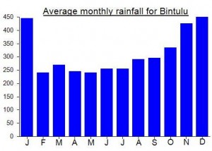
Local Average Monthly Rainfall (mm):
Location
Click on the blue arrow ![]() (top right) to see your current location on the map
(top right) to see your current location on the map