Facts
- Elevation: 1,523 m (4,997 ft)
- Prominence: 1,246 m
- Ribu category:
 Kurang Tinggi
 - Province:
 Nusa Tenggara Timur
 - Island: Lembata
- Coordinates: -8.2136, 123.7758
- Rating:
- Other names: Ujolewung, Ujelewungkedang on the Bakosurtanal map
- World Ribus ID: 69128
Photos
Bagging It!
Ili Uyelewun is one of the best of the ‘less high’ mountains in Indonesia. Although infrequently climbed, the grassy terrain allows spectacular views across Lembata island, including the smoking volcano, Ili Ape (Lewotolo), to the west. The mountain is no longer active, but an ancient, shallow crater still remains clearly visible at the top. There is also a very old vegetable garden which is passed by the trail, apparently a historical place of retreat during wartime or to avoid capture by slave traders.
Assuming that you are staying in the small town of Wairiang at the base of the mountain, you will see that it is a ‘twin mountain’. The grassy top closer to Wairiang is, infact, a couple of hundred metres lower than the sharp, pointy one behind, and so an ascent to the true high point directly from Wairiang would involve ascending the lower top first, the descending and then re-ascending. If you want to spend a night camping up there, which would undoubtedly be very pleasant if you have the time, then this route would be great. However, those keen on making a day-hike of it are advised to get an ojek round to Meluwiting (about Rp25-30,000 each for the hour-long journey).
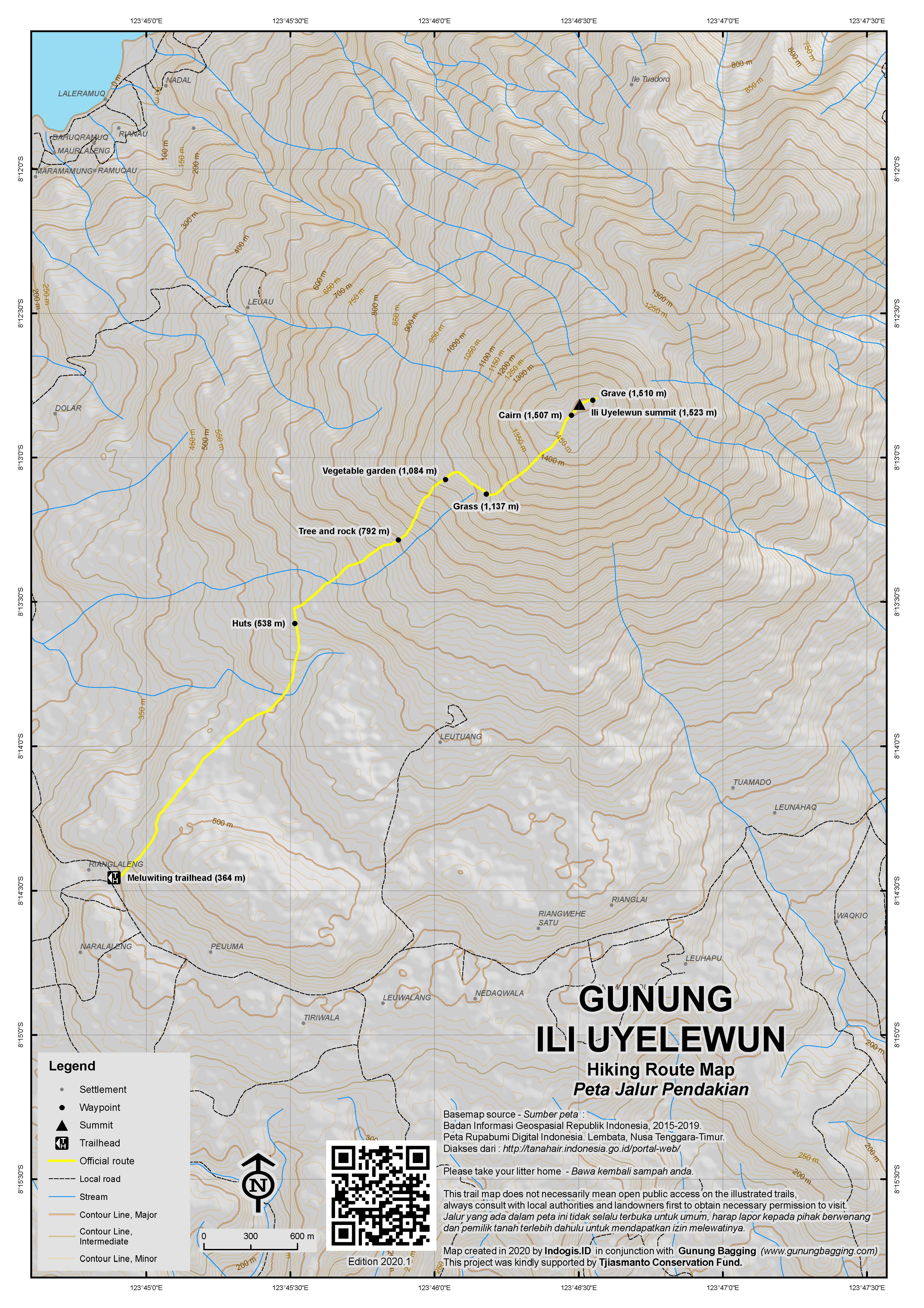
The trailhead (364m elevation) is an unmarked junction with a wide farm track leading up the hillside. You should be able to find a local guide around here if you ask (essential given the unmarked junctions). After an easy stroll up the track, it narrows and leads to the right up to a tiny hamlet (elevation 538m) of 3 or 4 huts (and usually several sacks of candlenuts ‘kemiri’). From here it is another hour and a bit through forest to the ancient vegetable garden (elevation 1,084m). There is a lot of birdlife on this mountain, thanks especially to the local people who, unusually, do not hunt them. It is at this vegetable garden that in centuries gone by local people would retreat in order to avoid conflict or capture by slave traders.
From this point on, the trail becomes a lot more frustrating, yet this is more than adequately compensated for by the stunning views of Lembata’s coastline and distant mountains to the west. From the vegetable garden, you have to follow a very rough, barely-visible, trail to the right, drop down very briefly, before reaching the lower end of the grassy part of the mountain (1,137m), which has scattered eucalyptus trees on it, so beautiful that in sunny weather it is hard to take a poor photograph here. There are also some large boulders, and any signs of a proper trail are hard to find from this point as you basically just head ‘up’ the grassy mountainside, taking care where you put your feet beneath the grass. The grassy ridge gets really steep all of a sudden, so take it slowly and sit down every now and again to enjoy the marvellous views. Finally you will reach what you think is the top – it’s actually the remnants of the ancient crater rim. Apparently the mound in the centre of the crater is where a village used to be many centuries ago, although our first impressions were that it was the overgrown volcanic mound itself inside the crater. Difficult to tell. The true summit lies a little behind the crater rim. It is best to do an anti-clockwise circuit, which takes about 1 hour in total (including a little time to enjoy the views from the true highest point). You will reach a couple of large cairns (or graves) just below the true summit, which, much like Gunung Mutis in West Timor, has beautiful eucalyptus trees growing on it yet still allows tremendous views in all directions.
The Bakosurtanal map labels the peak ‘Ile Ujelewungkedang’ with a height of 1,521m. Both this name and the old-fashioned spelling Ujolewung seem to have been overtaken in popularity by ‘Uyelewun’. Just beyond the highest point you can see the lower peak (1,376m on the Bakosurtanal map) closer to Wairiang and just how much of a drop there is inbetween them (the map says the col is at 1,213m). There are also two more ancient graves near here. Ili Werung, Ili Labalekang and Ili Ape (Lewotolo) are all clearly visible to the west in good weather conditions and the top of Ili Uyelewun is one of the most pleasant summits in Indonesia. Allow yourself extra time so you can sit here in the perfect temperature for at least an hour. Needless to say, the descent (by the same way down the steep grassy ridge) requires a great deal of care. A twisted ankle would be quite possible given the terrain. In total it takes about 4 hours to the top, 1 hour for a circuit and then 3 back down to the main road. A thoroughly recommended gem of a mountain.
Bagging report by Dan Quinn (July 2013) with spelling update in June 2020
Trail Map
 For a high quality PDF version of this and other trail maps, please download from our Trail Maps page.
Practicalities
-
- Getting there: Wairiang is a small port town on the east coast of Lembata. It takes about 4 hours to reach from Lewoleba, along one of the bumpiest roads in Indonesia. The trailhead at Meluwiting is about 1 hour from Wairiang.
- Accommodation: Yusuf’s Catholic Billiard House in Wairiang provides the only accommodation and meals in town – at very reasonable prices.
- Guides and GPS Tracks: Want a PDF version for your phone? Looking for a guide? Need GPS tracks and waypoints? Ili Uyelewun information pack can be downloaded here.
- Permits: None required but take a photocopy of your passport photo page just incase.
- Water sources: None available – take sufficient supplies with you.
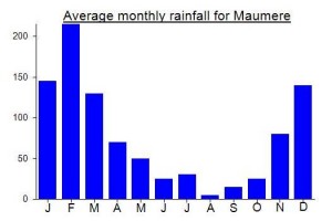
Local Average Monthly Rainfall (mm): 
Click on the blue arrow ![]() (top right) to see your current location on the map
(top right) to see your current location on the map


 (9 votes) Add your rating
Great traveling, and I am very proud of you about your faith to climbed my mountain (ILI) Uyelewun,.
I hope you will make a story in a book, so the other people in your Country, can traveling to My Village Kedang, Lembata, NTT, Indonesia. Any kind of Kedang cultures you can see, learn and enjoy.
Thanks for your came to my Village
Berto Leumara
ili uyolewun is my village, i recommend you to visit my village again. there are so many unique places that you watch.
Whilst in East Timor over the New Year period I met a chap called Michael from near Wairiang at the East Timor Backpackers in Dili. He told me the locals were having difficulty with the usual water sources on the slopes of Ili Ujolewung. Apparently they collect rainwater to use as drinking water at the moment and will at some point soon need to do a community ceremony to try to get the natural mountain water sources back again.
Well, after 15 days in Nusa Tenggara Timur, I would say that this was definitely one of the highlights.
We arrived in Wairiang by basic chartered boat from Baranusa, Pantar (for a rather expensive Rp 1 million for the slow, 4 hour trip). The only place to stay in town appeared to be an old-ish building with billiard tables next to the market. The friendly owner, Yusuf, and the array of Bintang beer on display were good enough for us so we settled down for a drink and a chat about our plans. The basic rooms were cheap too… though I forget exactly how much now, probably about Rp50,000 per person.
Amazingly, for this remote part of the eastern archipelago, a French guy and German girl arrived the same day. They had been told the public boat to Alor leaves today. Alas, they had been misinformed and would have to wait for another 2 days! So we had a good chat and a beer and the German girl Veronika agreed to join us the following morning for the hike up Ujolewung.
There are two ways to get to Meluwiting as the road encircles the mountain, and I would definitely recommend following the coast first thing in the morning for some great views of Ili Ape and the island of Batu Tara in the distance. At the trailhead we found a couple of farm workers to take up up to the top for 150Rp (75 each) Our ojek boys were keen to join us too so there were quite a few of us. When we got to the ancient veg garden, we all started chomping on sugar cane.
Given the tough terrain, maybe Veronika regretted climbing with us, asking at one point ‘You do this for fun?’ and exclaiming ‘I don’t have travel insurance!’ I have a funny feeling though, that like me, she will look back very fondly on the day and especially the brilliant views over the island of Lembata.
Note that the ‘j’ seemed to be pronounced as a ‘y’ by most of the local people, hence the alternative spelling ‘Uyelewun’.
Me and Nick chartered a basic local bus to take us to Lewoleba the same afternoon, as the French chap met us back at the billiard house after having enjoyed a more relaxing day at nearby Pantai Bean (the white sand beach a few kilometres out of town).
nice work on the ribu upgrades.now its worth to put this one back on the itinerary.any info at all from anyone would be greatly appreciated as this ribu looks great from afar.