
Facts
- Elevation: 1,796 m (5,892 ft)
- Prominence: 1,057 m
- Ribu category:
 Kurang Tinggi
 - Province:
 Sumatera Selatan (South Sumatra)
 - Coordinates: -3.8837, 103.2784
- Rating:
 (Bagged it? Be the first to rate it)
 Loading...
 - Other names: Gumay, Bukit Tuguk
- World Ribus ID: 69192
Bagging It!
We do not know much about this peak but a local contact in Pagar Alam traversed the range recently and got a GPS reading of 1796m at the top. Gumai/Gumay is the name of the range and the name for the actual peak is Bukit Tuguk. Starting point on the Pagar Alam side is Kampung Sukabumi (elevation around 700m) and it is possible in two days apparently or even one long day.
Practicalities
-
- Getting there: By road or by taking the daily Wings Air flight to Pagar Alam from Palembang.
- Permits: Unknown
- Water sources: Unknown
Local Average Monthly Rainfall (mm): 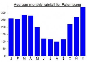
Location
Click on the blue arrow ![]() (top right) to see your current location on the map
(top right) to see your current location on the map
Here’s a Youtube video about a local group who did a full traverse over Gumai, or Gumay with a Y as they spell it. Much shorter from the Pagar Alam side – something I have pencilled in to have a go at in 2020….
https://www.youtube.com/watch?reload=9&v=IxyozdCVOzI
Well apparently local hiker Maman has been up to the top with his friends. The summit, or what he refers to as the summit, is supposedly only 1km from cultivated fields so could therefore be done as a day hike if a trail remains. It seems they followed a tough route up via a river and only found the cleared forest area on their descent route. Haven’t seen GPS tracks yet so can’t confirm if they bagged the true peak, but this one is probably worth further investigation next year, especially as there is a daily Wings Air flight to Pagar Alam from Palembang. Megalithic sites in the area of considerable interest too….