
Facts
- Elevation: 1,992 m (6,535 ft)
- Prominence: 1,065 m
- Ribu category:
 Kurang Tinggi
 - Province:
 Nusa Tenggara Timur
 - Island: Flores
- Coordinates: -8.7172, 120.3271
- Rating:


 (4 votes) Add your rating
 Loading...
 - Other names: Poco Mblek
- World Ribus ID: 69186
Photos


Bagging It!
Curunumbeng is one of the most mysterious and little-known mountain peaks in Flores. Even the name is largely unrecognized by locals and may actually refer to a lesser mountain top further west. The mountain is never climbed for pleasure’s sake, but there are hunters’ trails on the lower slopes and one track actually leads over the shoulder of the mountain range from Matavai to southern Lembor. As there are two or three peaks of a very similar elevation, it probably makes more sense to attempt to reach the true summit from the eastern side at Kampung Bumbek near Matavai.
However, given that the trail Gunung Bagging used from this side in July 2013 reaches a dead end just a few hundred metres below the summit ridge would suggest that an attempt from the northwest at Rangga, climbing via the second-highest peak first before ascending again to the true Curunumbeng peak may be worth a go. The top of Curunumbeng is actually quite close to the Trans-Flores road, but all of the hairpin bends in this area make it very difficult to work out where best to start, even with a GPS! The route towards the mountain from the east starts in Kampung Bumbek (900m) where you will be able to find a local villager to take you up the mountain, and leads through coffee plantation and then up a valley with a small stream in it. Apparently, some help was given to the villagers’ water supply and irrigation methods earlier in 2013 by a Dutch organization based in Ruteng.
The trail is well-defined but muddy and steep and therefore very slippery indeed. Looking back, you will see the western end of the Mandasawu mountain range between two outlying peaks of the Curunumbeng range. In less than an hour you will pass a minor junction. Down to the right are a couple of farm huts and it is via this route that villagers sometimes climb over the shoulder of the range and descend towards Lembor. This takes one full day if you set out early enough, but sometimes the locals camp one night on the mountain. Continuing straight ahead towards the top of Curunumbeng, the trail passes along a flat, overgrown ridge before leading into proper forest. The trail is pretty steep in parts but it leads directly towards the summit. Unfortunately the trail simply peters out at a pile of wood cuttings (1,560m). It is possible to climb another hundred metres or so up steep, pathless forest terrain to a cluster of large rocks (1,685m). It should have taken you about 2 and a half hours to reach this point. From the rocks, you can look back down towards the village and also up at the very wild, dense forest near the summit. Villagers have never heard of Curunumbeng, and call this mountain Poco Mblek. To complicate matters still further, the Bakosurtanal map lists the peak as ‘Poco Desu’ with a height of 1,992m. From here, the terrain is so steep and overgrown you would need at least one night of cutting a trail to the top to get up there and no villagers from Bumbek have ever been up there. When they do climb, it is to collect wood, or go hunting wild pigs. It appears there are very few – if any – deer (‘rusa’) living up here. Apparently there is a junglefowl population living on the slopes of the mountain but we never saw any nests on our trip.
To descend the same way shouldn’t take more than 2 hours. For those considering trying to reach the summit from a different route, the most obvious would appear to be from Rangga (about 900m) which is on the northwest side of the mountain range, closer to Lembor. However, as noted above, the first peak you would reach from the Rangga side would only be the second highest. Whether there is a trail to the top of it remains to be seen, but the chances of a trail leading down a couple of hundred metres to the col between the two before then leading up to the true highest peak is pretty unlikely.
Bagging information by Dan Quinn (August 2013)
Practicalities
- Getting there: Curunumbeng is about 1 and a half hours from Ruteng or 2 and a half from Labuanbajo. There is an airport in Ruteng but the local flights are only a couple of times per week. Labuanbajo has plenty of flights, mainly to Denpasar.
- Accommodation: There are several hotels in Ruteng. Unfortunately none of them are good quality or good value. The only exception is not a hotel as such but the Wisma Santa Maria Catholic Convent House. This is usually booked up so make sure you reserve a room well in advance. If staying in the popular Labuanbajo, there are plenty to suit all budgets but be aware it is quite a distance to the mountain.
- Permits: Not required but take a copy of your passport photo page just incase.
- Water sources: Take sufficient supplies with you, although the trail crosses a stream several times near the beginning on the Matavai route (last at around 1,200m).
Local Average Monthly Rainfall (mm): 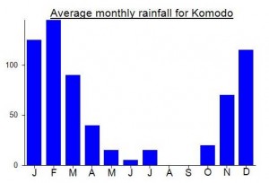
Location
Click on the blue arrow ![]() (top right) to see your current location on the map
(top right) to see your current location on the map
Well, Curunumbeng turned out to be a bit of a bastard. After we’d been to Ranakah, we continued on towards Curunumbeng. Only trouble in Flores is that the roads are so windy it seems you’re getting closer when all of a sudden the road starts taking you further away again.
Given how bad my internet connection was, and how lacking in names all of the maps I had seen of the area were, I asked a guide for the name of any villages on the east side of the mountain. ‘Dintor’ was the answer, a village on the road down to Iteng on the south coast where you can take a boat to Mules island.
Turns out there are two ways to get to Dintor from Ruteng. The quickest and least congested is over the pass to the south of Ruteng between Poco Ngandonalu and Poco Mandasawu. this must be the highest road in Flores (forgetting the track up Ranakah) as it reaches about 1720m above sea level at its highest point. It’s a very scenic road too, but damn cold when the sun goes behind cloud.
The road then leads downhill. I was aware we would need to cut across to the right, but unfortunately the road kept leading down back towards sea level and the south coast. Gorgeous rice paddies though. Anyway, after asking for Curunumbeng many times and simply puzzling the locals, I decided that as we were now back down at 300m above sea level there was no way I’d climb it that day and that probably the way to approach the mountain was not from the (south) east but from the north east via the Trans-Flores towards Lembor. A Kepala Desa confirmed what I thought. He reckoned it would take 6 hours to reach the base of the mountain, and on foot, from this side. So… forget DINTOR!
So, late lunch back at Agape in Ruteng it was. If the so-called tourist information centre at the Dahlia Hotel had actually had a map of the area I might have been able to point out the location of the mountain. But nobody had a clue beyond the regular 3 or 4 normal tourist trips that most foreigners go on to visit traditional villages etc etc.
After a couple of beers I decided to give it another try the following day. Jeff my ojek guy, who continued to call me ‘father’ at every opportunity, said he had found information on Curunumbeng and that it was best approached from Rangga village near south Lembor, West Manggarai. Quite a distance back towards Labuanbajo. Ok then, let’s do it tomorrow.
The early morning views from the main road across Flores just west of Ruteng at 6am the next morning were just beautiful. Curunumbeng was visible to the west, its lower portions hidden by lower peaks surrounding it. After an hour, we were very close, just 4km from the summit at one point. But Jeff reckoned we had to continue to south Lembor. Another hour on the snake of a road, and another 10 people who had never heard of Curunumbeng.
Eventually we got up to Rangga village (about 900m above sea level), but it was obvious that the peak nearest to the village was a second, slightly lower, western top in the range. Perhaps only 30 or 40 metres lower but still not the true ‘puncak tertinggi’. The villager we spoke to first said he had never been to the top (of the nearest one) but there were lots of tracks lower down.
After not finding anyone who could confirm the existence of a track from the nearest peak to the higher peak I decided that it might be better to head back east to the point where my GPS had given a distance of only 4km or so from the main road to the true peak. That would be the way to do it.
So, another hour back along the road to the junction at Desa Matavai (unsignposted, but near a dome-shaped hill). Down at Kampung Mblek the villagers had never heard of Curunumbeng either, but one of them was willing to take me up to the top for 150,000. Done.
So we climbed it and, as reported above, got to the steep cliff-like area below the summit. Just 300 and a bit metres below the top and only 600 metres distance away. Very frustrating, as we had been doing so well, getting so close that I had the impression there would be a trail to the top after all. It was a pleasant enough hike but I do wonder what would have happened had I climbed as originally planned from Rangga.
Note that the only leech I encountered in the whole NTT trip was on this mountain.