
Facts
- Elevation: 164 m (538 ft)
- Prominence: 164 m
- Peak category:
 Spesial
 - Region:
 Singapore
 - Coordinates: 1.3547, 103.7764
- Rating:


 (3 votes) Add your rating
 Loading...
Photos
")
")
")
")
")
")
")
")
")
")
")
")
")
")
")
")
")
")
")
")
Bagging It!
Bukit Timah may only be 164 metres high, but it’s Singapore’s national highpoint. The name translates in English as ‘tin-bearing hill’ although it was apparently known originally as Bukit Temak, or ‘hill of the Temak trees’. Bukit Timah was the site of a battle in February 1942 between Japanese and Allied forces. The Japanese won, at least temporarily. A plaque commemorating the battle was unveiled in 1995 at Bukit Timah Nature Reserve.
At 163.63 metres high, Bukit Timah is not a challenging climb and is one of the easiest of all national highpoints worldwide. It is, however, an important exercise spot for Singaporeans and a Marilyn (a hill or mountain with 150 metres or more of topographic prominence).
Starting in the west at Hindhede Drive, follow the obvious signs and road up the side of the hill and into Bukit Timah Nature Reserve. This is a popular spot with local walkers, joggers including people walking backwards. It’s probably the only remaining primary forest in Singapore. It is also popular with monkeys but be sure to refrain from feeding them as the fine for doing so is astronomical. The area is great for birdlife and insect life such as cicadas.
Most walkers will be at the top in less than 30 minutes. The final, most direct trail leads up some steep steps and onto a short boardwalk next to a compound with severe-looking keep out signs before emerging in a clearing where there is a telecommunications towers, a shelter and an inscribed summit stone ‘Bukit Timah 163.63m’. You can return the same way or continue beyond the summit and follow the wide track as it loops back round.
Some keen hikers have claimed that the true highest point of Singapore is actually 300 metres west of the large boulder and rest area, in an unmarked area of forest with no official access. However, other reports suggest that the west summit is less than a metre lower than the official summit, but lower nonetheless.
The BTMM is not an elaborate abbreviation of an obscure revision of a route up one of Malaysia’s mountains but rather a mythical beast of local folklore that haunts the dreams of many a Singaporean. Short for Bukit Timah Monkey Man, it is thought to be an immortal creature and has allegedly been spotted in the area on many occasions spanning the years 1805 to 2020.
An ascent of Bukit Timah can also be combined with the Jelutong Tower between Upper Peirce Reservoir and MacRitchie Reservoir which has pleasant views. To continue eastwards on this rewarding trek with a total distance of around 11 kilometres, head down the Catchment path which brings you out at a cleared section of land popular with mountain bikers. Take a right here (downhill) and bear left onto Rifle Range Road. This is the least inspiring part of the half-day out, as it crosses BKE (Bukit Timah Expressway) and leads past numerous restricted-access compounds.
Finally you will be back on a proper trail which seems to be an area with a population of wild pigs. The trail veers right towards the Jelutong Tower, but a hundred metres before the observation tower is the important junction where you need to decide to either take the Nature Trail via the ranger station and path to the north of the reservoir or the southern path which skirts the edge of the reservoir and an extensive golf course.
Whichever one you choose, be sure to climb to the top of the Jelutong Tower first for a decent view over Singapore’s wildest zone, and note that there are well-constructed boardwalk sections on both potential routes from here. Look out for eagles, herons, monitor lizards and so on. Fit hikers can complete the full trek from the base of Bukit Timah to the MacRitchie Reservoir cafe and car park in around 3 hours.
Time required for return hike: Only an hour or two for the shortest route, or as long as a half-day depending on any additional route chosen.
Bagging information by Dan Quinn
Practicalities
-
- Getting there: Very easy. Start from Beauty World MRT station or take a taxi.
-
- Permits: Not required. Free entry daily from 7am to 7pm.
-
- Water sources: Take bottled water with you.
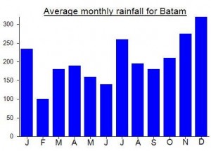
Local Average Monthly Rainfall (mm):
Location
Click on the blue arrow ![]() (top right) to see your current location on the map
(top right) to see your current location on the map
Origins and Meaning
Literally ‘tin-bearing hill’ though it may have originally been known as Bukit Temak, or ‘hill of the Temak trees’.