
Facts
- Elevation: 1,010 m (3,314 ft)
- Prominence: 975 m
- Peak category:
 Spesial
 - Region:
 Peninsular Malaysia
 - Malaysian state: Johor
- Coordinates: 2.0426, 103.5612
- Rating:


 (3 votes) Add your rating
 Loading...
 - Other names: Also spelt ‘Berlumut’.
Photos


Bagging It!
Gunung Belumut is Peninsular Malaysia’s southernmost peak over 1,000 metres and is therefore arguably the closest excellent day-hike for hikers living in Singapore. It is located in the Hutan Lipur Gunung Lumut (Mount Belumut Recreational Forest) around 30 minutes by car from the pleasant town of Kluang. Most fit hikers can reach the top in less than 4 hours, and be back down in less than 3, though there are two potential camping spots.
Though many mountain hikes in Malaysia require an e-permit from the forestry website, in 2022 it is possible to turn up and pay on the day (RM30 per foreigner and RM10 per Malaysian) though it is advisable and perhaps even essential to have a guide with you and book in advance on weekends. Note that the office is closed on Mondays so it is probably impossible to hike up on a Monday as the gates will be locked. Note also that the gates are not usually opened until 0830 so there is little point aiming for an earlier start than that.
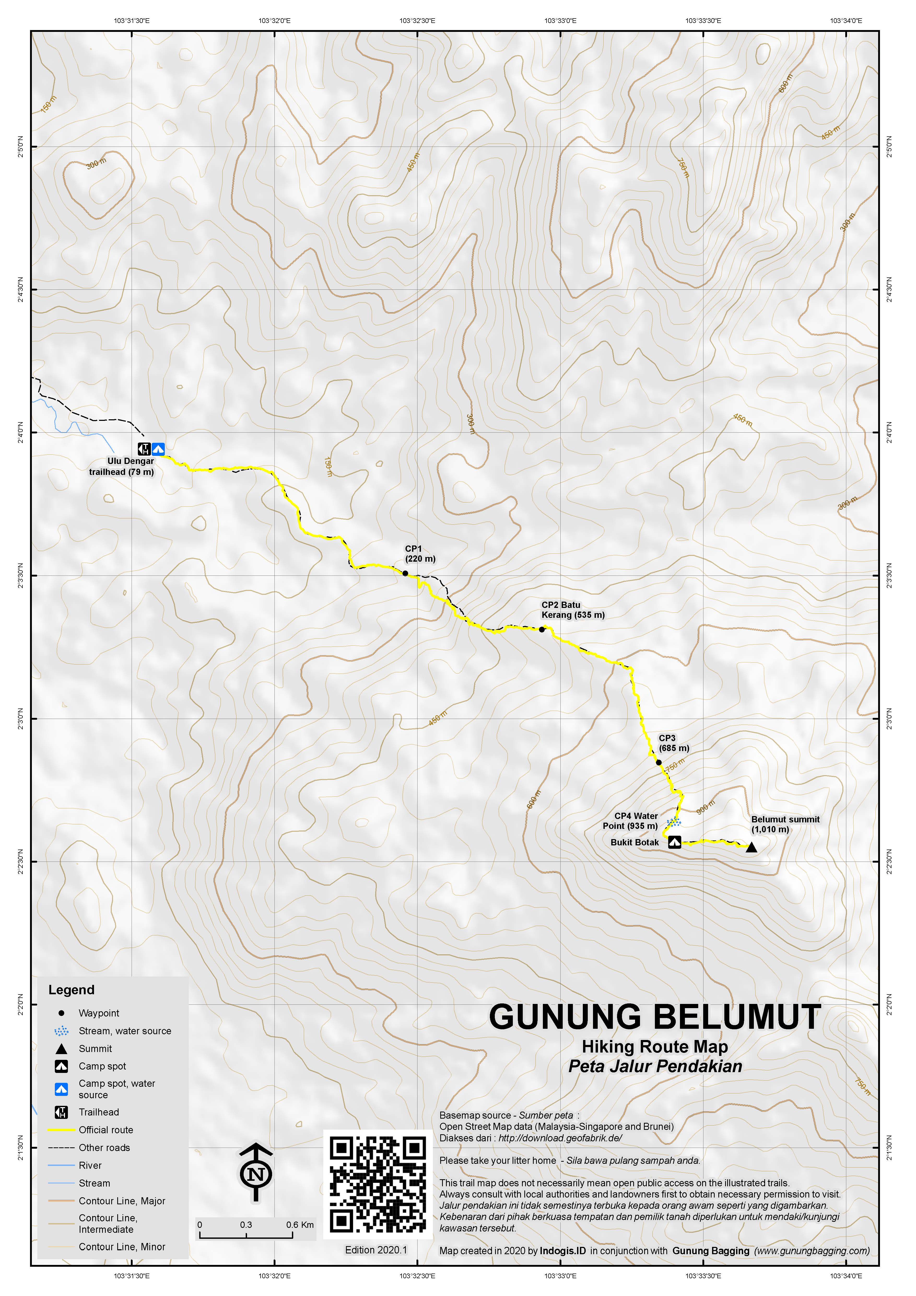
There are 4 ‘checkpoints’ on the way to the peak and several water sources. If the signs are correct, the trail length is 6,030 metres, or just over 6 kilometres (one-way).
The trail starts at the Gunung Belumut Recreational Forest car park in Ulu Dengar (51m above sea level) and leads over a suspension bridge and then up some steps and finally onto normal forest trail towards Checkpoint 1 – Lata Tengkorak (197m). The Checkpoint has a little sheltered seating area to the left of the trail. There is a camping area on the right of the trail plus a junction where a right turn leads to the waterfall.
And then the trail gets considerably steeper, with some roped sections which greatly assist over what is occasionally tricky terrain. Checkpoint 2 is a named after a fabulous weathered rock known as Batu Kerang (‘clam stone’, 494m). This is the perfect place to stop for a quick break and there are some decent wooden benches on which to sit. It marks roughly half-way in terms of distance, elevation and (hopefully) time, with most being able to make it here in less than 2 hours from the trailhead.
Beyond Batu Kerang, the trail leads along some delightful forest ridge, mostly less steep than before. Checkpoint 3 Lara (673m) is next and comes before another very steep section of trail complete with ropes. After a cluster of rocks (768m) the panoramic views begin, mainly across to the shapely peak of Gunung Chemendong (846m, lying to the north). The vegetation here begins to change and it becomes clear you are reaching the higher slopes of the mountain.
Checkpoint 4 Kabus (903m) is a pleasant section of forest ridge complete with a couple of wooden benches. Down to the left of the trail is a water source, but as it is a fair distance down it is much better not to use unless you are camping or for an emergency. This is the last water point.
Beyond Kabus is a cleared area (939m), known variously as Bukit Botak, the false summit or Helipad. There are some decent views here and it is an obvious spot to camp. The true summit is a further 10 or 15 minutes via a short drop between the two tops. Finally you will emerge at an area of large boulders and various official signs. This is the top of Gunung Belumut and the views are excellent in clear weather.
There are two especially large rocks. One is a smooth, round boulder. Until 2022, there was a short ladder fixed to the base to allow hikers to clamber onto the top of the boulder but in 2022 this has gone, perhaps to avoid any accidents occurring. But the highest rock is a striking shard, jutting up towards the sky like a sword. This is known as Batu Keris and is the true peak of Gunung Belumut. Obviously, reaching the top of Batu Keris is highly technical and way beyond what most ordinary trekkers would want to consider. Yet the 1,010m figure given to Gunung Belumut is on account of Batu Keris – your GPS on the grassy area with the signs will show a lower figure of around 1,005m.
Since 2022, new signs point towards both Gunung Chemendong (846m) to the north and Gunung Gua Harimau (889m) to the south. Both additional peaks are also located in the Gunung Belumut Recreational Forest. However, for most hikers, adding either or both of these on to your Gunung Belumut hike would require a lot more time. The 34km circuit of all three peaks is growing in popularity and is known as Trans CBR – Chemendong, Belumut, Rimau.
Most hikers descending from the top of Gunung Belumut will be back down at the trailhead in well under 3 hours.
Bagging information by Dan Quinn, May 2022
Gunung Lambak (510m)
If you have a few hours spare in the Kluang area then a hike up Gunung Lambak is definitely recommended. Not only is it located close to the centre of the town, no permits or guides are required and it is popular and with sufficient signage that it is one of the few hikes in Malaysia that do not present an issue for solo hikers.
Gunung Lambak has two peaks, the main northern peak which is 510m (with a prominence of 446m) and a southern peak around 40 metres lower at 470m (with a prominence of 105m). Both can be combined in a circuit, but less than 10% of the hikers ascending Gunung Lambak will bother visiting the southern peak. Gunung Lambak is an inselberg – a small, isolated mountain peak which rises abruptly from flat surroundings. The area is extremely popular with local joggers and walkers, and at weekends you may struggle to find anywhere near the entrance to park aside from along grass verges.
The trail (90m) leads past a toilet block and several recreation areas, alongside a pleasant stream (Sungai Lambak), past a shelter (72m) and through an official trail entrance (88m) where there is a trail map. The trail gets a little steeper, and passes two junctions (at 205m and 214m). The second junction, complete with fishpond fountain, more signs and seating areas, is the crucial one because it is here that the summit trail divides into two. On the left is the steeper or extreme route to the top, and on the right is a gentler, longer route up, via the col with the southern peak.
It makes sense to go up one way and down the other. Assuming you opt for the shorter, steeper route up to the top, there are lots of tree roots to contend with, but also lots of ropes to help you up. The summit is crowned with a telecommunications tower and a large wooden viewing platform. The platform sign suggests no more than 20 hikers ought to be on the platform at the same time and also prohibits the feeding of monkeys. However, if it’s a weekend then expect to see well over 20 hikers up there, and several of them feeding the monkeys that congregate.
The view is quite pleasant but it can be very busy. Most hikers should be up here in about 1 hour from the trailhead. Heading down the gentler way back to the junction is an enjoyable stroll through forest along a well-maintained trail. The col (365m) between the north and south peaks is well-marked and this is where you can optionally head up to the less popular peak if you prefer more solitude. Otherwise you can be back down at the road in much less than an hour.
Trail Map
For a high quality PDF version of this and other trail maps, please download from our Trail Maps page.
Practicalities
- Getting there: For Malaysian domestic flights and flights within Southeast Asia, for example to Kuala Lumpur, we recommend Baolau. Ulu Dengar trailhead is located near Kluang and is often hiked as a day-trip from Singapore as it is only 2 hours by car. The trailhead area has food stalls and a toilet block. The gates are only opened at 0830 and the place is entirely closed on Mondays.
- Guides and GPS Tracks: Want a PDF version for your phone? Looking for a guide? Need GPS tracks and waypoints? Gunung Belumut information pack can be downloaded here.
- Permits: In 2022, very simple. RM30 per foreigner or RM10 per Malaysian at the office at the trailhead. In previous years it was a real hassle, with a permit required from Johor Forestry (a ludicrous RM150 per group irrespective of group size) and the need to get a nominal roll stamped at Kampung Gajah Police Station. Let’s hope it stays simple. You can now register and pay for an e-Permit online from the Forestry Department of Malaysia website.
- Water sources: CP4 Kabus (903m) is the last water point though the actual stream is a fair distance down from the checkpoint.
- We recommend Safety Wing as travel insurance for overseas travellers and tourists hiking up to elevations not exceeding 4500 metres.
Local Average Monthly Rainfall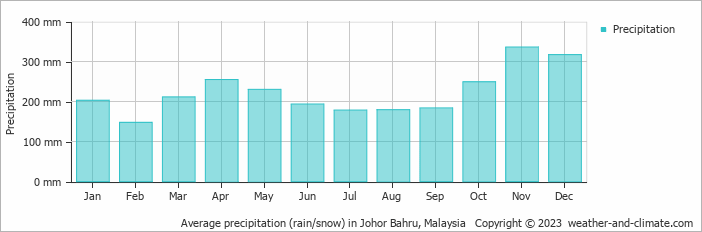
Location
Click on the blue arrow ![]() (top right) to see your current location on the map
(top right) to see your current location on the map
We’re planning to do this Gunung Belumut hike, is there still a need to apply for permit or we can just turn up at the trail head and pay on the spot for the hike up?
After a couple of trek cancellations in Perak and Kelantan, I decided to head in the opposite direction and spend a few days in Malaysia’s deep south. I’d already hiked Gunung Belumut, so I had a look at what else might be possible, ideally without the hassles of waiting 2 weeks for permits to be issued.
Gunung Pulai was an obvious good choice, being 654 metres high with a prominence of 619m. Open at 8am. A very popular peak due to its location at the southern tip of Mainland Asia, just a short hop from Singapore. There are forest trails which require permits and guides or a tar road all the way to the summit compound at the top which you can hike without a guide and for a very small fee at the entrance. It seems that you cannot truly reach the summit as it is inside the compound but it is clearly a decent hike. There’s a huge fine if you walk into the forest rather than stay on the road. So I decided I would stay on the road.
Typically for Malaysia, land of bureaucracy and cancellations, renovation work was going on near the top of the road to the summit. Unlike other locations, which allow for hiking even if some renovation work is happening, Gunung Pulai higher slopes were closed for a full three months (allegedly re-opening at the end of October – presumably until the next light shower leads to more renovation work being needed). I thought I would drive there anyway, as it was close to where I was staying at Pontian. The base of the mountain is an entire village of its own – Kampung Seri Gunung Pulai – and an industry of stalls, tourist sites and car parks to go with it. I parked up and went to the entrance where there are three books for hikers to sign. One for men. One for women. And one for foreigners. That is a bit weird.
But it was a good sign that we could go at least part of the way up the ‘jalan tar’. I had paid RM1 to get in, then RM3 to park the car. Not bad so far. There must have been another 50 or so hikers on the road, even on a weekday, perhaps oblivious to the closure, or perhaps not. Anyway, after just 5 minutes of hiking up a road, past the junction for the toilets, there was a man standing next to a single plastic barrier and his car. It was his job to tell everyone to go back down. Utterly bizarre. So, put on your shoes, pay your 4 ringgit, march up the road then get herded back down again. People were disappointed, naturally. That guy will be quite bored after 3 months of telling people to go back down.
Was it worth 4 ringgit? Maybe not. There has to be a better way of doing things. Surely. Or at least give people their money back. What a regimented experience.
I drove on further east to have a look at Gunung Panti (531m, prominence of around 363m), a much wilder peak with several access points none of which are obvious with big signs like Gunung Pulai. Panti has a lovely flat top, two peaks (west and east) and a ‘transformer rock’, and is sufficiently wild that you probably shouldn’t hike there alone. Indeed, you need a permit and guide sorted out over 2 weeks in advance, the usual inflexible rules that are the enemy of spontaneity, unless that spontaneity is a closure or cancellation. I did enquire with one local guide, but it would have cost RM665! For up to 7 hikers, yes, but what a high price for a half-day hike. The reason is of course, moneyed Singapore, which has a negative impact on those smaller groups or single hikers and a very positive impact on guides who can earn megabucks for a 3-hour walk in the forest. But it would have taken 2 weeks to process the permit anyway.
So my only joy in Johor, aside from a yellow rooftop hotel room at Pontian, was heading north to the excellent Gunung Lambak, a civilised spot which made a great morning out.
I went there on 2024JUL07, turned back arnd 2/3 of the trail by the guy on kapcai due to landslide.
I went there agin on 2024SEP07, was turned back just like you due to different landslide (in SG we called them “slope failure”).
After almost a year break, decided to give it another try on 2025AUG06 and manage to go up Telekom Malaysia (TM) towers.
Compared to the last time I was there in early 2024 & one phone ago, there are a lots of signs up there to warn hikers not to take photo of the installation.
The e-permit online is not RM150 / group though, it is RM150 / participant.
Hi, how do i book a day trip? Any transportation from CIQ to the hiking place?
You go via an official Johor mountain guide and they will sort it out for you.
How to get permits for camping?
Sort out via an official Johor mountain guide.
Hi. I’m thinking of hiking this mountain but wondering about the permit. You mentioned permits could be purchased on the spot. Do you have the address of the office that sells the permits? And would I be allowed hiking up without a guide?
Hello there. The office is in the carpark at the trailhead. As for hiking without a guide, I am not sure about the rule but it is definitely not a good idea to hike alone.
Hi, can I apply for permit and get a guide on the spot at the trailhead? How do I get a guide?
Hi there, I just completed my hiking to Gunung Belumut yesterday. and now is to have a guide with you is a must and you need to book in advance.
for those normal person, usually took 5 hours go up and 4 hours down to the base. So remember to bring more drinking water with you for the 9 hours hike.
How do you book in advance?
Hey how to book the guide and permit. It would be great if you could pass the contact of the guide you had thanks
Hiking is a hobby as most would like to reward themselves with a final view from the mountain top, fresh air and relaxation. Stay there for an hour then descend to town for some local acclaim coffee. Can the authority consider open the gate at 7 am? It would help the communities as well, hikers will shop, fill up the restaurants and so on….they don’t has to rush back.
After the troubles on Tioman’s Gunung Kajang, Gunung Belumut was an absolute delight! Kluang town is rather pleasant too and was a great base for a couple of days. It took me 3hr15 up and 2hr15 down and this being newly-reopened after the whole Covid chaos, I can only congratulate the Johor authorities. Firstly for simplifying the permit procedure and secondly for the excellent ropes now in place. The trail is clear and atmospheric and it deserves to be explored by many more. I guess I could complain about the 830am start (surely 7am would make more sense, based on daylight) and excess signage at the summit, but generally I think the Gunung Belumut is a great example that others could follow. Barely a speck of litter either. A clean, well-managed mountain with some excellent views. Thoroughly recommended, even if you can’t technically bag the highest point (Batu Keris). Perfect as a warm-up for something longer but well worth the hike for its own sake. All JB and Singapore hikers should give it a try.
Contrary to my final sentence in the write-up above, some folk do actually hike Chemendong-Belumut-Gua Harimau in one expedition (usually 2 nights camping) thought Chemendong can be hiked separately as a day-hike. Gunung Gua Harimau/Gua Rimau (Tiger Cave Mountain, allegedly 889m high) lies to the south of Belumut peak, on the other side of a considerable valley between the two.
Was supposed to hike Gunung Belumut on Monday, after Endau Rompin’s highest peak Gunung Besar on Sunday, but disaster struck when my would-be guide, Azizi, to whom I sent the money in advance, never appeared to meet me and stopped answering his phone.
More details will be up on the Besar (Endau-Rompin) pages shortly, but in brief we arranged two days of hiking in Johor, I sent the money in advance, mainly due to the laborious permit procedure, and then he never showed up or answered my calls when I arrived, effectively stealing the money. Instead I spent my weekend making a police report in Johor Bahru and complaining at Johor Tourism office about the complicated permit procedure and excessive price of simple hikes in Johor. Not a great weekend.
In short, Azizi, or Muhammad Azize Bin Zuaini to give his full name, is worth avoiding at all costs. Do not trust this individual. I will do what I can to see that he never works as a guide again. If there is any justice I will have my money returned and the extra charges I incurred by having to book extra hotels paid for out of his pocket. Realistically this could well not happen, but please do not trust this ‘man’. He is a liar and a cheat and is unlikely to be employed by Johor Parks as a guide ever again after this incident as my police report has been forwarded to management.
General advice to all trekkers…. never send any money to guides in advance except if it is direct to a National Park account. There are lots of thieves out there. Don’t be fooled by the smiles or ‘friendliness’. It’s fake.
Hello, can I know public transportation from Kuala Lumpur to this place?
Haven’t done this myself yet (but planned for a July weekend). Probably easier from the south (Johor Bahru or even Singapore) to Kluang train station and then taxi but also possible from the north. As with many of Malaysia’s mountains it is much easier if you have a local friend with a car! A shame there is no ‘ojek’ culture as in neighbouring Indonesia as this would make life a lot easier for hikers.