
Facts
- Elevation: 3,085 m (10,121 ft)
- Prominence: 1,811 m
- Ribu category:
 Sangat Tinggi
 - Province:
 Nanggroe Aceh Darussalam
 - Coordinates: 4.2517, 97.4205
- Rating:

 (3 votes) Add your rating
 Loading...
 - Other names: Previously listed as Bukit Mugajah
- World Ribus ID: 69044
Bagging It!
This mountain was reached in 2018 by Metalik hiking community. It took an astounding 27 days!
Practicalities
-
- Getting there: It takes roughly 12 hours to reach the starting point from Medan by private car.
- Accommodation: In view of the long journey it is a good idea to stop on the way from Medan.
- Permits: Likely to be time consuming!
- Water sources: Available in various places – your porters/guides will advise how much bottled water you will need to bring.
Local Average Monthly Rainfall (mm): 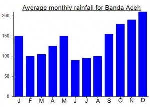
Location
Click on the blue arrow ![]() (top right) to see your current location on the map
(top right) to see your current location on the map
Origins and Meaning
Bukit Mugajah means ‘mountain of elephants’ in Acehnese. (Thanks to Mark Durie, 2011). Presumably the mountain is, or was, home to a large number of elephants. ‘Kurik’ means ‘chicken’ in the Gayo language.
There are a few rivers on the trek to gunung Mugajah.
There are quite a few accommodations in Blangkejeren so no worries there.
The trek to gunung Mugajah (aka gunung Kurik) starts in desa Uring (kecamatan Pining), approx. 2 hour drive from Blangkejeren.The trek takes approx. 14 days in total. Its a challenging but yet rewarding trek. If you can not make the ascent to gunung Mugajah, you can hike to gunung Lembu instead. Gunung Lembu is about 3000 m high too.