
Facts
- Elevation: 2,372 m (7,782 ft)
- Prominence: 2,045 m
- Ribu category:
 Tinggi Sedang
 - Region:
 Timor-Leste (East Timor)
 - Coordinates: -8.6417, 126.5958
- Rating:


 (6 votes) Add your rating
 Loading...
 - Other names: Often spelt ‘Matebian’. Some maps suggest that nearby Matebean Feto is the highest mountain in the range but this is untrue.
- World Ribus ID: 69034
Photos


Bagging It!
The Matebean (also spelt ‘Matebian’) massif is one of the wildest and most rugged mountain ranges on the island of Timor, and has a fascinating yet bloody recent history. It has two summits – Mane (the ‘male’ – 2,372 m – true summit) and Feto (the ‘female’ – 1,963 m). The more southerly Mane is the higher of the two. Although Matebean Mane is not the highest mountain in Timor Leste, it is one of the most impressive in the remoter parts of the Eastern Islands of the archipelago.
A climb to the summit of Matebean Mate can be made easily in one day – subject to the weather. Likewise, Matebean Feto can be climbed in one day – both from Uaiboro. Both peaks can be done in three days with camping on the mountain. The best months for climbing in Timor Leste are August through October when cloud cover on mountains is minimal. (The southern side of Timor receives higher rainfall than the north, and the south-facing mountains attract cloud cover even in the dry season.) In fact, guides may refuse to take trekkers up the mountain if the cloud cover is too low and rain is forecast. The route up the mountain is crisscrossed by numerous tracks leading to gardens, and cloud cover presents a challenge – a guide is essential.
Matebean literally mean “Spirits of the Dead” (mate –‘ death’, bean – ‘spirit’.) It is an important and special place to the people of Timor as this is where the spirits of the deceased reside. Climbers are requested to speak quietly and show respect for this most sacred place. Folklore holds that only the souls of the good go to Matebean.
During the Indonesian occupation from 1975, the mountain was a guerrilla hideout where many people sought refuge from the military in caves on the mountain. (Extract from Trekking East Timor). “During 1977–78 many people died in this area in battles with the Indonesian military. Aircraft came from Kupang bombing and strafing throughout the morning. At lunchtime the aircraft would land at Baucau, and the attack would resume in the afternoon. There was also navel shelling from the south coast. There are many bomb craters. The track passes over caves inside of which are the bodies of Timorese killed by the Indonesian bombing. Large rocks have been jammed down to close the entries.” Villagers informed us of one cave in which some 200 people were trapped due to the bombing and had died inside. Many people also died from famine as they were unable to tend their gardens.
Gunung Matebean is reached from Bacau via Laga (about 18 km) on the north coast and then south-east to Baguia (alt: about 450 m) another 43 km. The Laga-Baguia road was asphalted during the Indonesian occupation but has now falling into disrepair and is extremely rough. The trip takes the best part of 5-6 hours by car. There is limited public transport from the Baucau bus terminal to Baguia – enquire in advance about busses. Trucks with tarpaulin are irregular but possible for those with time on their hands.
An impressive ruined building, in classic Portuguese style, ‘Escola do Reino de Haudere’, lies on the right hand side of the road (now known as ‘the old school road’) at Hiberi about 2-3 km before Baguia. This was originally a Portuguese school built in the early 1900s but destroyed in the 1940s during the Japanese occupation.
The people in the Baguia area are Macasae and Nauoti; most speak some Indonesian. We were able to communicate with most people in Timor Leste in Indonesian, learnt during the Indonesian occupation and now from Indonesian TV. Few people outside the main towns now speak Portuguese although, we understand, that it is being introduced into schools as the national language (why?). English is also being taught. We were pleasantly surprised to meet some high school students in Baguia who were fluent in English – perhaps they have an excellent teacher!
Accommodation in Baguia is limited. Guest House Rabilai (+670 7737 6137, 7620 2770), run by Sr. Martino and his wife Sra. Adelaide, offers basic but quite adequate accommodation and meals; six rooms (with small double beds), two of which have attached bathrooms ($15-20 per room). Another building is currently under construction. The rest of our group stayed in a similar guest house below the Pousada. Just recently, the government has renovated an old Portuguese fort and opened the Pousada Baguia as a guest house to promote tourism. This looks a bit more ‘up-market’ compared with the guesthouses although not as ‘homely’. (Pousada: Portuguese, originally hilltop fortresses, now often renovated as hotels, as is being done in Timor Leste.) This was the district administrative centre where in 1959 the last uprising against the Portuguese colonizers took place with bloody reprisals against the Timorese.
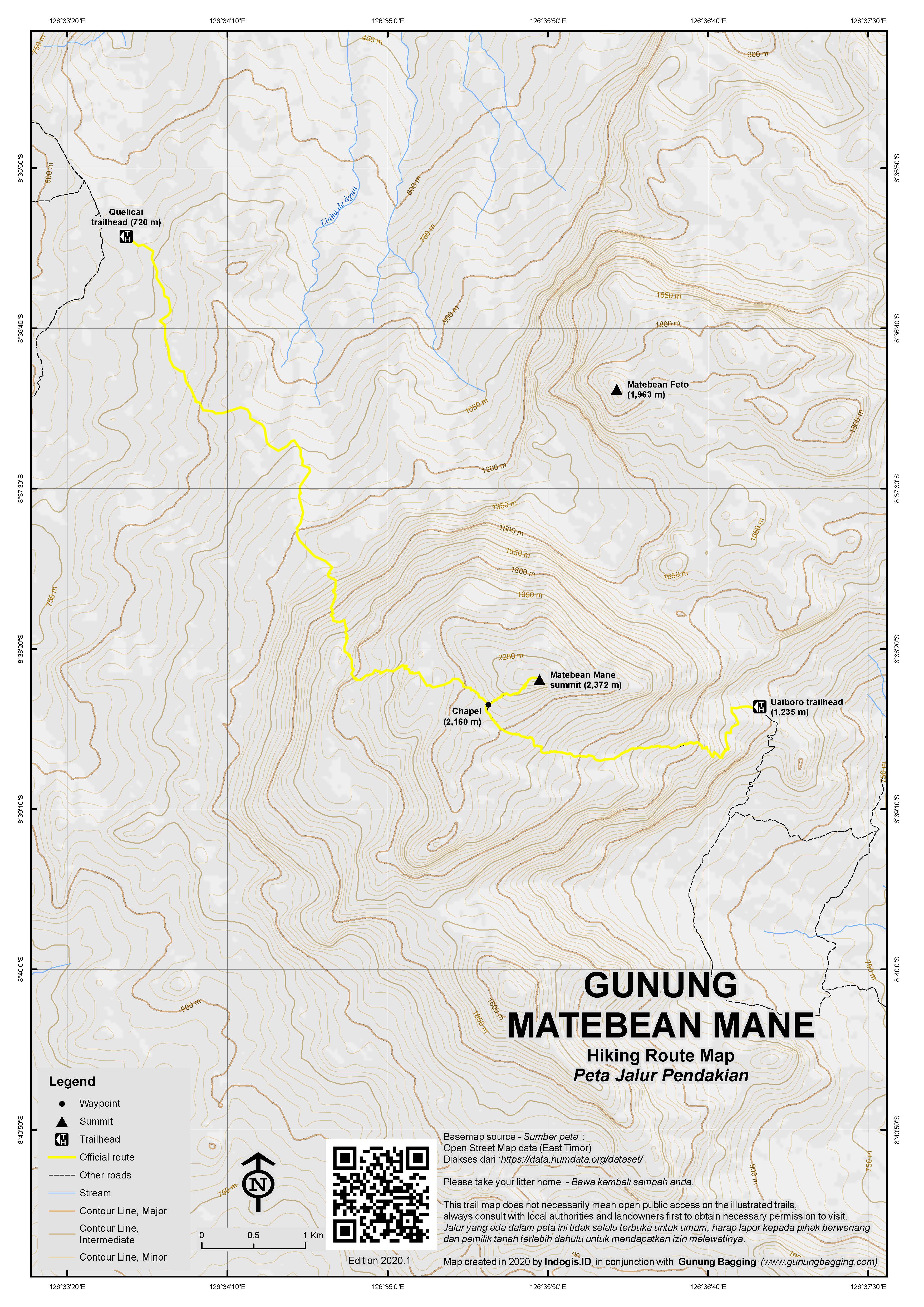
Baguia is the last place to get basic supplies such as snacks and water. The climb starts at Uaiboro (pronounced ‘whey-bore-oh’) and follows the blue line on the Indonesian topographical map (see photo). The road from Baguia to Uaiboro is via Ossohuna (alt: about 800 m). The section, Baguia – Ossohuna (about 7 kms), is passable by 4WD vehicles and motorbikes. The road to Uaiboro branches off to the right just before Ossohuna. Even 4WD currently cannot pass the Ossohuna – Uaiboro section (motorbikes can, but probably quicker to walk as the road is steep). We walked this section, about 2 km, 250 m vert., about 30 mins. At Uaiboro (about 1,235 m), we registered our names in a log book at the house of the community leader Martino de Silva and paid an ‘entrance fee’ of $20 for the group. (They also offered us coffee after our descent, which was most welcome.) Guides are available at Uaiboro ($25 per guide); but it is advisable to make arrangements in advance through the guest house or police station in Baguia for guides.
The trek was less demanding than we had expected. In fact, as the blue line on the map indicates, the trail traverses the steep slopes diagonally making for a more gently ascent. It passes initially through gardens and cow pastures on steep slopes then through Eucalyptus groves at about 1,900 m with thick grasses below. Interesting fluted, karst limestone outcrops are passed on the way.
At about 1,500 m we passed into the cloud zone with visibility reduced to about 20-30 m. Guides are essential if for no other reason than to avoid becoming lost in ‘white outs’. After about 3:30 hrs from Uaiboro and at about 2,160 m, there is a small, dilapidated ‘capella’ (chapel) where the villagers pray each October (and in which cattle take shelter turning the ground into a quagmire of mud and manure!)
At this point the trail to the summit (another 220 m vertical, about one hr) becomes somewhat steeper with some big rocks to scramble up. Since we were in heavy cloud, we adopted the Wolf Pack formation of a ‘wise old (slower) wolf’ in front, women and children in the middle and the fit young guys at the back. This worked well keeping the group together and in close contact with the guides. The total ascent from Uaiboro to the summit, about 4.5 km, took about 4.5 hrs including breaks. Our group included a 9 ½ year-old boy who had no problems with the trek although he did need a hand up on some of the bigger rocks.
The summit is jumble of large, monolithic karst limestone rocks. And on the highest point is a small, elegant stature of Christ. On this occasion, given the heavy cloud, we missed out on the spectacular views across the island – from the north to the south coasts. “The views are truly stunning with a feeling of being on the top of the world. On a clear day Tasi Feto (feto female) = northern sea, and Tasi Mane (mane male rough = southern sea) are clearly visible.” (Trekking East Timor)
Our descent by the same route was, in fact, more difficult than the ascent. The limestone rocks, when wet, are extremely slippery causing some people to fall onto their backsides. In these conditions, allow more time for the descent. Otherwise, the descent may take only about 3-3.5 hrs.
The mountain can also be climbed from the north-west at Quelicai (720m) but this is a much less popular approach.
Submitted by: Nicholas Hughes, July 2018, updated by Dan Quinn
Trail Map
For a high quality PDF version of this and other trail maps, please download from our Trail Maps page.
Practicalities
- Getting there: Three hours from Dili to Baucau by road. Five hours from Baucau to Baguia by 4WD/bus/truck. 2-3 hours from Baguia to Uaiboro on foot. If you have a small group and/or sufficient money it is best to hire a 4WD and driver in Dili. Or hire motorbikes.
- Trip planning assistance: Would you like Gunung Bagging to personally help you in arranging your whole trip? Please contact us here.
- Permits: Register at Uaiboro before the climb. Be advised that guides may not be willing to climb in the wet season or cloudy weather.
- Water sources: There will be some available at Uaiboro/Waiburo/Oeiboro (1,200m) which is the final hamlet.
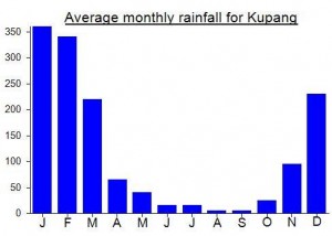
Local Average Monthly Rainfall (mm):
Location
Click on the blue arrow ![]() (top right) to see your current location on the map
(top right) to see your current location on the map
Unfortunately my Matebean experience was one to file under ‘severe headache in most regards but mildly amusing in retrospect’. Still, it was fun getting out there……
I had heard many good things about the Matebean range – rugged terrain and extensive views of a fairly remote part of the archipelago. Given that the end of December is wet in much of Indonesia, it seemed a good time to hop over to Timor Leste where chances are the weather would be a bit drier. Whereas Ramelau is a fairly popular hike and pretty easy to arrange, I was having a bit of difficulty getting in touch with anyone via email who lived in the local area and had climbed it. I tried Carlito, one of the contacts listed on the excellent ‘Trekking East Timor’ website. He was very knowledgeable indeed and I suggested a basic itinerary including one night sleeping up on the mountain at the church hut. Given how long it takes to get out there along rough roads from the Baucau area it seemed like a night either at the foot of the mountain or on the mountain itself would be necessary (unless you happen to own your own car in East Timor and are happy to make a very long day of it).
When I told this gentleman my not unreasonable budget for the trip, he misread my email as 100USD per day plus transport and accommodation when infact I had offered 100 USD for the trip to/from Dili (doable in 3 days or even 2 if you set off very early and get back very late, though a stop off at Baucau town is recommended). When he realised my genuine offer, he scoffed that he would be better off to ‘stay at home to plant coffee, rambutan and oranges’ as ‘Timor Leste cost living is very expensive’. It is also one of the poorest nations in Asia and you might think that local people would jump at the chance of a moderate wage (and potential future wage from other hikers). So I would just have to wait until I reached East Timor itself and ask around for anyone not expecting the cursed ‘NGO Price’ for simply walking up a hill.
At Jakarta’s comical Soekarno-Hatta airport things got off to a poor, and thus normal, start as Sriwijaya announced a delay to the departure (their first of the day for this aircraft). On arrival at Denpasar you must transit from domestic to international, at present a considerable walk, and then get back on the same plane. At Dili everything was simple – 30 USD for tourist visa (various other prices for transit, study, work) and then 10 USD in a taxi into the city.
The East Timor Backpackers is the place to stay if you’re on a budget – or just want a decent bunch of other tourists to chat to. 12 USD a night for bunk beds, higher for own room. It’s at the western side of town on the main road from the airport, so actually you can probably get a taxi a bit cheaper than 10USD (it’s only 5 USD BACK TO the airport). Do note that, compared to Indonesia, most things are considerably more expensive – especially accommodation, western-style food etc. However it can still all be done on a tight budget if you don’t mind eating simple meals.
The first thing that struck me about Dili was the number of excellent restaurants – notably several Indian establishments within 2 minutes walk of the Backpackers.
To get out to Baucau, you can either rent a car and driver (90USD per 24 hour period plus fuel costs), rent your own motorbike from Tigerfuel near the Backpackers (35 USD per day plus fuel) or simply hop on one of the very regular local buses. Wikitravel suggests you need to head out to the eastern side of the city to Becora bus terminal to catch a bus to Baucau but this is not necessary. Just walk down to opposite the Lita Store (about 20 minutes on foot straight down the road eastwards from the Backpackers). Given how busy the bus was with locals going home for New Years Eve, many of them carrying upside-down chickens with their feet tied together and the typically noisy music system ‘entertaining’ passengers, I opted to climb onto the roof of the little bus, alongside a couple of other roof riders and some vegetables. It turned out to be a wise decision for what is an incredibly scenic 3 or 3 and a half hour trip along the coastline. Price is about 4 USD but I was charged only 3 USD as I spent much of the time on the roof (which is a half fare apparently).
When you reach the Baucau bus terminal, do not be put off by what must be one of the most disgusting and primitive terminals in Southeast Asia. Truly revolting. I found a shop selling beer to soften the blow of standing in filth whilst I waited, hopefully, for one of the trucks out to Baguia where I planned to spend the night and find a guide for Matebean Mane.
After an hour a truck arrived, bound for Baguia. Excellent. I got onboard the tarpaulin covered truck. An annoying little kid kept prodding me from outside the truck and I had to be careful about watching my wallet as I had the feeling he would have it given the smallest of opportunities. After a further hour we set off along the crater-covered road by the terminal. We pulled into a gas station to fill up. This took some time and I came to the conclusion the driver was having a smoke and/or a chat somewhere, despite the bus being full up. Needless to say I was the only foreigner onboard this peculiar form of transportation and it was beginning to take its toll. Finally we set off again. No more excuses to stop. Or so I thought. Amazingly, the truck pulled back into Baucau bus terminal and the driver turned the engine off and ordered everyone out.
This was too much. I decided to spend the night in Baucau and try to find someone local to Baucau with a motorbike who had climbed Matebean or would at least accompany me up there. So I hopped on a minivan down to the Old Town (much nicer – wide, empty streets, the Pousada hotel and restaurant) where I stayed at Tato Toti Guesthouse just 1 minute further down the road from the salmon-pink pousada. Tato Toti was 35 USD for a room with hot water (that’s half the pousada prices) or 30 USD for cold water. The pousada itself was full of the rich type of NGO worker and well-to-do foreign families, the type that might pay Carlito enough to leave his rambutans and his oranges!
Just down from the guesthouse is a stairway leading up to some old building or other, with views down to the coast which is several km away down the road (and supposedly has a reasonable place to stay near the beach, for those with extra time).
The Victoria Restaurant is reasonable place to eat, but given the large portion sizes and wifi availability at the pousada I decided to eat there.
I had told the friendly chap running Tato Toti that I was looking for someone to accompany me up Matebean and did he know anyone in Baucau, or even just someone with a motorbike that was keen on hiking? He said it would be easier just to go back to the terminal in the morning and wait for a truck to appear but after my previous experiences I told him I was trying to avoid that if at all possible. Eventually he said he had found someone with a motorbike who would come at breakfast time the following morning. And, as I chomped on the fried egg and delicious local bread (not horribly sugar filled like in Indonesia) a young student appeared on his motorbike. His Indonesian was pretty good but he didn’t look like much of a hiker. He seemed to know the way to Baguia, at least, so I decided to go with it and see how much he wanted for 2 days – 1 night on the mountain – return trip from Baucau. He first asked for 150 USD – a ridiculous sum. I told him my maximum budget was 100 USD for EVERYTHING. Otherwise I would just have to try to get the truck up there again.
Eventually he agreed and we set off along the main Lospalos road to the church at Laga (after 45 minutes) where the right turn by what looks to be an old cement Pancasila sign leads up to Baguia along bumpy farm tracks. There are some stunning views to be had along this track, both towards the mountains inland and also out to the coast.
Unfortunately my ‘guide’ seemed a little too concerned about getting his motorbike muddy so we travelled at a snail’s pace and he also kept asking me to alight on steep sections and walk up behind him, when infact his motorbike would be quite fine with me on too. He was a Baucau City Boy, it would appear.
3 and a half hours from Baucau, fording a couple of rivers, and we were on the main street of Baguia. Given it was already lunchtime we decided to continue on as far as we could get so that we could get walking in time to reach the church hut before dark. A further hour along steep tracks, via a right turn at Ossahuna, and we were at a second, minor, junction up to Waiburo/Uaiboro. We left the motorbike with an old lady who lives near the junction and proceeded to find someone local who might point the way to us. My ‘guide’ said we would need to bring a village kid up with us and it would only be 10 USD or so. I said ‘fine’ but this is to come out of the 100. He wouldn’t budge on this and so I reluctantly agreed. We went to a cluster of huts on the right of the track up to Uaiboro. No village kids, but a sprightly old man who was willing to take us up to the church hut and leave us there. Perfect – I could, after all, use my GPS the following morning to get us down the same way again.
Then he asked – via my ‘guide’ from Baucau – for a whopping 30 USD for an afternoon’s stroll. I was incredibly annoyed by this, but agreed, given how far I had come to visit this mountain and how much we really needed to get up there before dark. So we proceeded up the wide farm track zigzagging up to the hamlet of Uaiboro, where the hiking trail properly begins. On the right is a rugged cliff peak (Mount Ossasama) and several graves at the col between it and Uaiboro.
This area has a deeply sad recent history, with thousands left dead through fighting with the Indonesian Army and also aerial bombardments which have left craters higher up the mountain still visible today.
(You can google ‘Matebian massacre’ for paragraphs such as this….. “the final piece of territory to fall to the Indonesians in the last days of 1978. It had provided sanctuary to many thousands of East Timorese during the final months of Abri’s so-called ‘Encirclement and Annihilation’ campaign. It was eventually captured after weeks of aerial bombardment and massive civilian casualties.”)
Anyone over the age of 35 will probably have some pretty shocking memories from the late 1970s and will probably have lost many relatives and friends during the conflict.
On the left of the track, at the entrance to Uaiboro, is what looks like a little warung or village shop. We were invited by two women to sit down on chairs – something in Indonesia I always see as a bad sign. It means delay, negotiation, sussing the foreigner out. And it’s the last thing you want, however well intentioned, when you’ve just started climbing a mountain you’ve effectively spent several days getting to the base of.
‘You can’t climb this mountain.
It’s windy up there’.
It’s ok. I have a GPS system and have climbed many mountains before. It’s windy in the UK, where I come from, almost every day!
‘But it is not allowed. It is dangerous’.
Well, I have read many reports of people climbing this mountain.
‘But it is December. You may not climb in November, December, January. February. You will have to come back another time.’
I don’t have another time. This is my holiday time now. I have come a long way to climb this. I know that Ramelau is open for hiking and Ramelau is much higher than Matebean.
‘But Ramelau is different. Not the same as Matebean’.
…..and so, after a great deal of effort getting to East Timor, then to Baucau, then finding transport, then sitting on a motorbike up bumpy tracks for several hours….. and I wouldn’t be allowed to climb. Inside I was furious but I just turned to the motorbike boy from Baucau (who was clearly delighted he wouldn’t have to do any hiking!) and told him we would return immediately to Baucau. We trotted back down to the local man’s house (all of 40 minutes there and back). He then requested his money via Baucau Boy. I asked him how much he was asking for, given that we had not climbed the mountain. ‘Oh, just 20 USD’. For a 40 minute walk! Once again, I was fuming inside, on what was supposed to be both a holiday and a way to promote the mountain to many others, but just decided to hand over the cash to the mercenary old man and walk away with a very poor impression of him.
To add insult to injury, or perhaps that should be injury to insult, a teenage girl pretended to hurl a rock at my head and laughed as we passed along the rough farm track back out to Baucau. I had read online about hostility to foreigners at Quelicai on the western side of the mountain (another potential access point – there is accommodation at the Matebian Guesthouse) but had heard nothing about trouble on the eastern (Baguia) side. In retrospect perhaps I should have called off at the police station in Baguia to speak to an official about getting some form of written permission to climb the mountain but in reality I was knackered as it was. And I was glad to get out of there.
The sky was a perfect blue and there was to be no rain for the next 36 hours or so. It would have been perfect weather at the top of the mountain! Baucau Motorbike Boy didn’t have the sufficient moral compass to suggest a fee more appropriate for what was a failed attempt. So I was 120 USD lighter from this single infuriating day. It wasn’t a great start to my impressions of East Timor, and constituted a dismal end to my 2013 hiking, but hopefully things would improve for Ramelau at the start of January.
Getting back to Dili took longer than expected, with 5 buses all trying to fill up at once instead of utilising the very modern concept of ‘a queue’! So all 5 buses sat waiting for around 2 hours each before all leaving more or less at the same time. On the way back the bus I chose broke down, I stayed on the roof away from the chickens and the loud music, and admired a particularly fine view of a narrow, knife-edge ridge near the coast about halfway between Baucau and Dili.
Another odd thing on Wikitravel is all this advice for ‘Malays’. I wondered why it was so dangerous for Malaysian (and perhaps Javanese) women to go out alone at night. All this advice for Malays. Was it because of the conflict with Indonesia? It was on the return trip to Dili that I worked it out. It was referring to ‘malaes’, the local term for white person. Personally, I felt I was coming down with a rare tropical illness called the Matebean Malaise.
Once again, don’t get off at Terminal Becora in Dili. Wait for the Lita Store from where you can walk a few minutes along the pedestrian area on the seafront back into town.
After all this it was with considerable relief that there was still room available at the Backpackers so I sat out back at the ‘Smokehouse bar’ and quaffed a few much needed Tiger beers.
So, final advice: if you’re rich or have a group of 3 or 4 I would rent a 4WD to get up to Baguia. Ask at the police station for a guide. And outside of March-October might present problems such as I had with the locals and the terrible ‘windy’ conditions.
According to the following excellent website on hiking in East Timor, the actual name of the highest peak in this mountain range is Matebean Mane – Matebean Feto is apparently lower.
http://trekkingeasttimor.org/?page_id=60