
Facts
- Elevation: 2,024 m (6,640 ft)
- Prominence: 1,295 m
- Ribu category:
 Tinggi Sedang
 - Province:
 Kalimantan Utara (North Kalimantan)
 - Coordinates: 2.4829, 116.4938
- Rating:

 (2 votes) Add your rating
 Loading...
 - World Ribus ID: 69118
Photos


Bagging It!
We currently know very little about this peak – please contact us if you can provide any information.
Practicalities
-
- Getting there: Unknown
- Permits: Unknown
- Water sources: Unknown
Local Average Monthly Rainfall (mm): 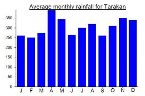
Location
Click on the blue arrow ![]() (top right) to see your current location on the map
(top right) to see your current location on the map
Last August 2025 we took a plane from Tandjung Selor to Long Ampung with the idea to descent Kayan river with a packraft kayak and climb Kujat from the west side, starting from the river. Luckily, we realise on time that our plans were a little crazy because of the danger of some rapids and we gave it up. But we took some pictures of Mt Kujat from the plane in case are useful for somebody in the future.