Facts
- Elevation: 940 m (3,084 ft)
- Prominence: 904 m
- Ribu category: Spesial
- Province: Kalimantan Barat (West Kalimantan)
- Google Earth: kml
- Rating:

 (3 votes) Add your rating
 Loading...
 - Other names: none
Photos


Bagging It!
Gunung Kelam is a huge granite dome near Sintang in central West Kalimantan province. It was first written about by German botanist Johannes Gottfried Hallier in 1894. He was the second European to climb it, after a Dr. Gürtler, and reached the summit ridge on five occasions between January 30th and February 13th 1894. Of particular interest to him was the large number of pitcher plants (Nepenthes). The following is his description:
“Mount K’lamm is a unique mountain of grand beauty. It rises singly and abruptly from a wide plane overgrown by young forest almost up to 1000 m above seal level and stretches approximately from west to east. Up to about half the mountain the steep slopes are covered with vigorous virgin forest, but the upper half is encompassed by mighty, almost vertical cliffs made of rock, over which water runs down in numerous gullies. Above the upper edge of the cliff there is high mountain vegetation compiled of bushes and small trees.
After once again climbing a steep slope with Gleichenia thickets, one stands suddenly beneath the high enclosing rock wall of the mountain ring. The smooth water-washed stone seamed with water channels shows no variation in structure, and it appears almost as if the whole mountain was composed of a single monstrous block of rock. On this wall has been erected the steep 45 metre high rattan ladder; it is secured only at the bottom, in the middle and in the solid earth at the top, the rest lying free against the stone…
Just above the middle of the ladder a small thin patch of humus is found, just sufficient to allow one to stand and rest for a moment. Both here, and at the top of the ladder a Nepenthes plant with unusually large pitchers has established itself. In the basal part, the pitchers are expanded into a jug shape. They are thus able, on the one hand, to take up a large quantity of water, and on the other, to hinder the escape of insects which have fallen inside, by means of the relatively narrow neck.”
Source: Wikipedia [translated from the original German in Pitcher Plants of the Old World and from the original Dutch and German in Pitcher Plants of Borneo]
Gunung Kelam remains one of the most important known habitats in the world for the pitcher plants, apparently being home to no less than 14 different species, one of which – the endemic Shield-Leaved Pitcher Plant (Nepenthes Clipeata) – was until recently thought to be the most endangered of all. The pitcher plants grow on the side of the vertical granite cliffs at an approximate altitude of between 500 and 800 metres. Most of the pitcher plants grow in obscure corners of the mountain difficult and dangerous to reach, yet numerous examples can be seen from the steep metal ladders which have since replaced the rattan ladder that Hallier used over a century ago – and which hikers must use if they wish to reach the summit ridge.
Kelam is a striking mountain from many angles both because it is an immense Ayers Rock-esque boulder and because the surrounding land is mostly very flat, with just a couple of minor hills to the northeast. More regular-sized boulders (for example, those measuring between 2 to 10 metres in height) can be found scattered by nearby village houses at the base of Kelam itself.
Just as those in Kalimantan call their highest peak ‘Bukit Raya‘ (‘big hill’ or ‘great hill’) despite its considerable size, so too do they refer to Gunung Kelam as Bukit Kelam. However, those who have climbed the ladders up its vertical cliff faces would probably agree that it deserves to be called a mountain rather than a mere hill! Although it can be climbed in a day by the reasonably fit and prepared, it is a significant hike up from about just 75 metres above sea level to an elevation of 940 m (the official 1,002 metres seems to be an exaggerated figure). A local man claims to have reached to summit ridge in just 45 minutes of running, but for dayhikes you should realistically allow 4-5 hours to reach the top and 3-4 to descend carefully. You’ll need a lot of water (minimum 3 litres each) and a decent sunhat and suncream, especially if you have pale skin. Wonderfully it would appear that there are no leeches on this mountain, which is an occasion worth celebrating in Borneo.
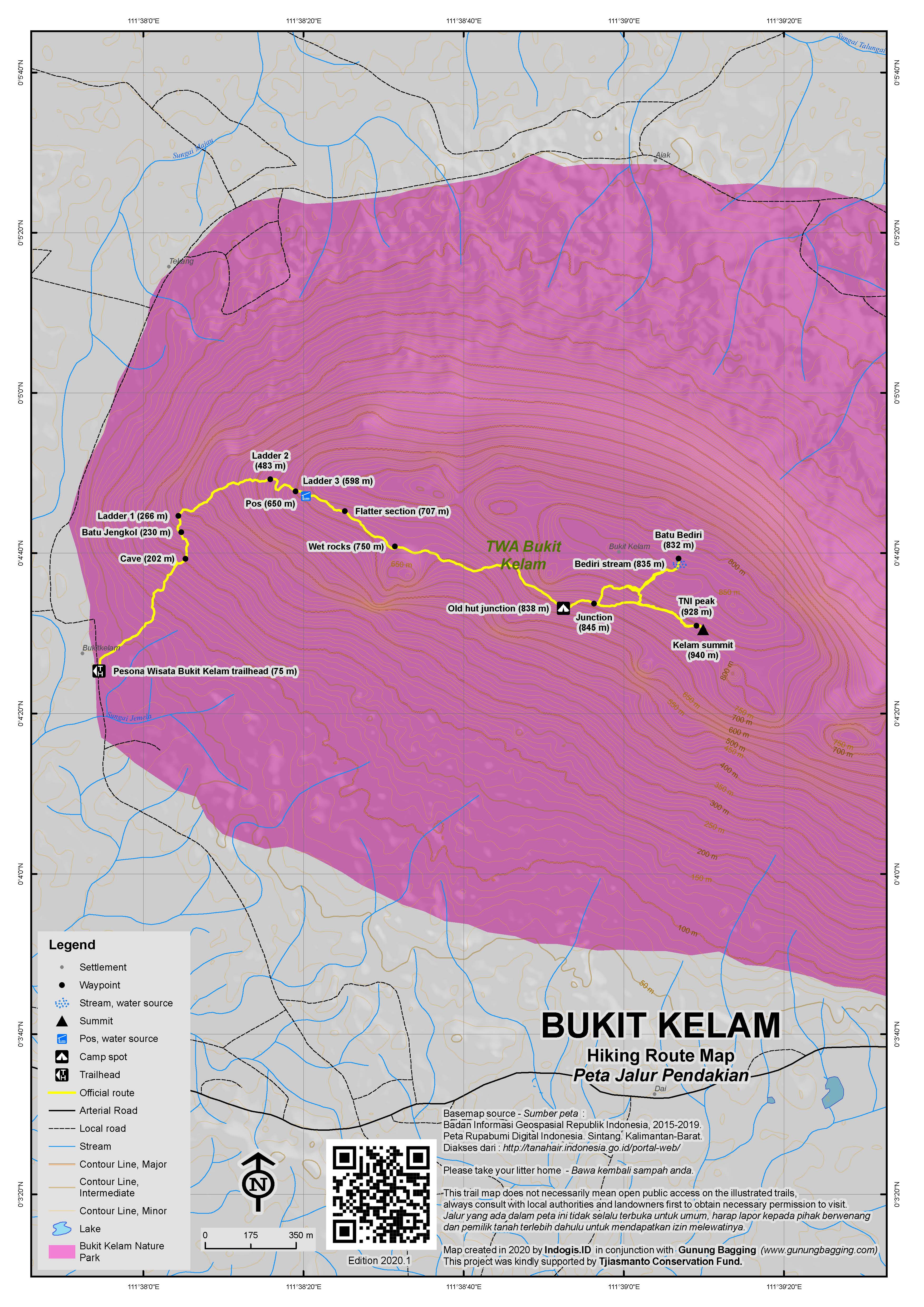
The trail starts at the signposted Pesona Wisata Bukit Kelam which is about 22 kilometres (or one hour by car) from Sintang. Follow the cement steps up past the stalls selling drinks (very busy with locals on Sundays) until you reach the sign with ‘puncak’ written on it. The cement steps continue up past a cement water pool (140m), up a short metal ladder (which is a brief taster of things to come as there are 3 longer ladder sections higher up) to a cave with a view (202m) and then a large rock (‘batu jengkol’, 230m) in a small grassy area with excellent views over the surrounding countryside. You will already be sweating by this point, so take a break here and admire the views. Unfortunately, much of the nearby land – which in Hallier’s time would have been primary rainforest – has been converted into palm oil (‘sawit’) plantations. It is a very sad state of affairs and represents a threat of such severity that it is not inconceivable that the majority of Borneo will be like this within the next couple of decades. Ecosystems destroyed for private profit.
The first of three increasingly long metal ladder sections (266m) soon follows and there is little shade to be found for much of the ascent from this point onwards. The views, despite being of palm oil plantations, are still pretty impressive, especially as you hang off the near vertical metal ladders screwed tightly into the granite cliffs. Take real care on these ladders and watch out for snakes which are quite common in this area. After the first major ladder section, the trail is very slippery and steep but you will probably find this to be more of an issue on the descent. On the way up, you will be wanting to take a rest every five minutes and quite possibly desperately looking for some shade from the hot sun!
The second long ladder section (483m) is slightly scarier than the first, being longer and steeper, but still only 20 metres up. Those with a fear of heights may find it rather worrying. And just when you think you’ve reached the end you see that metal bars (500m) lead the way across the cliff face to the right. This granite can be very slippery when wet so take things slowly as you negotiate this exciting stage of the hike. It is at this point that you will be able to spot pitcher plants by the side of the trail.
The third ladder section (or ‘fourth’ if you count the very short one down near the beginning) is the longest of them all. It is about eight sections of ladder in all, connected together on Kelam’s vertical rock-face for about 40 metres of ascent in total. It looks pretty daunting but it is by far the easiest way to the summit ridge (one group of local expert rock climbers actually climbed the cliffs – it took them 18 days in total!) If in doubt, you should probably just enjoy the views here before returning to the entrance. Those who continue are perhaps best advised to hold on tight and get on with the task in hand rather than looking…down!
At the top of the final section of ladder, there is a small ‘pos’ area (650m) near a pool of water. This water is ideal for pouring over your head after negotiating the ladders but if you want to drink the water there is a better source further to the right and down a little way (5 minutes or so). After this ‘pos’ area, the trail flattens considerably before leading up over an area of wet rocks and mud (750m).
A few hundred metres further along the trail (which drops down a little) you will reach an old sign at a mini-junction just above the remains of a large hut (838m). From this junction, take a left up to the highest parts of the mountain or, if you are staying the night on Kelam, down to the where the hut used to be. This hut was large enough to accommodate about 6 people inside and perhaps 4 outside the main room so assuming it has been rebuilt when you read this you won’t need a tent at all. There used to even be a cooking area, a washing area and a toilet (the latter was down to the right beyond a deep cave home to many bats).
The view from the hut location is wonderful so even if it has not been rebuilt this site is a good spot to camp. First of all you will notice a second hut further along which is in a state of disrepair. Looking down to the villages below you will see the wide Sungai Kapuas – Indonesia’s longest river – snaking through the landscape near Sintang. In the distance you may spot Gunung Saran and nearby mountains about which little is currently known. The view is roughly southwest, so you will catch half of the sunset from here. Best of all is the temperature – almost perfect, being at an elevation of 838 metres near the equator.
From the sign at the junction just above the hut it is just 10 minutes further to a signpost (845m, left for ‘Batu Bediri’ and right for ‘Helipad’). Batu Bediri is the place to admire the view northeast – an ideal location for sunrise. The helipad no longer exists but those of you who wish to reach the highest point of the mountain must go to investigate! But, first to Batu Bediri. The path climbs a little further before descending down the other side of the mountain about 50 metres or so (don’t take either of the minor trails leading left or right), to a height almost identical to that of the hut. A tiny stream of flowing water shoots down the side of the bare granite. This is the Batu Bediri area. The views are fabulous – the smaller hill nearby is Bukit Luit (436m) and behind it is Bukit Rentap (658m). More distant hills further to the east-southeast look pretty huge but are infact a similar height to Kelam itself (for example, the beautiful Gunung Bang – 1087m according to US Army maps). It would be wonderful to see Bukit Raya, Kalimantan’s heighest mountain, from here but given that it is well over 120km away it seems almost impossible from an elevation of just 830m. In good weather you will probably want to spend at least half an hour enjoying the views. As always on this mountain, take real care when exploring the near-vertical cliffs. It only takes 30 minutes to reach this point from the hut on the other side.
Once back at the sign to the helipad, continue up to the summit ridge of the mountain (just 20 minutes or so). Apparently a helipad was constructed here for the filming of a documentary, but it must have been a long time ago as there is no sign of a helipad now. What you will find is a new cement rock with TNI written on it (Indonesian Army) and then a minute further along are a couple of antennas and old cement slab with a piece of metal sticking out of it. There are no views here, but this is definitely the highest part of the mountain, and GPS readings suggest a summit altitude of around 940m. To visit both Batu Bediri and the summit from the hut I would allow about 90 minutes in total for a round trip. For the descent back down from the hut to the entrance it shouldn’t take longer than 3-4 hours and perhaps much less in cool (cloudy) conditions or for those who enjoy clambering down vertical ladders!
Once back down, have a look at the images on the side of the entrance to ‘Bukit Kelam’. They represent the mythical story of the origins of the mountain. If you have a spare hour, follow the link road via Merpak which circuits the base of the mountain. You will see several granite boulders and have the opportunity to take photographs of Gunung Kelam from a variety of different perspectives. And soon you will once again meet the main road back to Sintang.
Everyone has heard of the mighty Ayers Rock in Australia. The elevation of Ayers Rock is 863 metres and the surrounding land is already several hundred metres high. That means the actual formation of Ayers Rock is only 348 metres above the ground. Gunung Kelam rises from almost sea level to a height of around 940 metres or more. Therefore, if Gunung Kelam can be considered one huge rock, then West Kalimantan is home to what just might be the largest rock on the planet.
Bagging information by Dan Quinn (June 2013)
Trail Map
For a high quality PDF version of this and other trail maps, please download from our Trail Maps page.
Local Accommodation
Practicalities
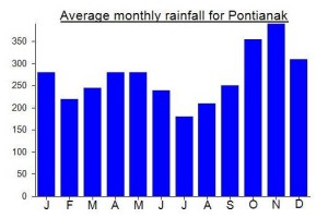
- Getting there: Allow at least 8 hours to get from Pontianak to Sintang by road (it’s a very bumpy journey). There is an airport in Sintang with daily flights to Pontianak.
- Guides and GPS Tracks: Want a PDF version for your phone? Looking for a guide? Need GPS tracks and waypoints? Gunung Kelam information pack can be downloaded here.
- Trip planning assistance: Would you like Gunung Bagging to personally help you in arranging your whole trip? Please contact us here.
- Permits: Rp5,000 per person for entrance ticket to the tourist area at the base of the mountain.
- Water sources: Available at 140m, 650m and near Batu Bediri on the northeastern side. However, best take your own given the information above.
Local Average Monthly Rainfall (mm):
Location
Origins and Meaning
‘Gunung Kelam’ means ‘dark’ or ‘dim’ mountain.
Hello,
An update on this nice hike we have done with my wife a few days ago.
The main piece of information is that THERE IS NO ACCOMMODATION ON TOP OF THE MOUNTAIN ANYMORE.
Judging by the shape of the hut we found, it has collapsed a while ago. Nobody was able to tell us when it happened.
We got the impression that the trail was not very popular, and at some point we had to fight our way through dense vegetation or crawl under collapsed trees. We met a lone hiker at the collapsed hut, but other than that, nothing. There were some traces of relatively recent firecamps, but you won’t be bothered by crowds up there.
Luckily, we were careful enough and had brought a tent which we managed to pitch in Batu Bediri. Beautiful place for a bivouac but rough night because it was virtually impossible to find a flat spot.
We did not explore the trail to the helipad. By the way, there is only one sign post at this junction, left for Batu Bediri, the right trail to the helipad is not indicated.
Overall the trail is very obvious, and if lost, one only has to track the litter, alas…
Otherwise, all the information given above by Dan is valid. I would just stress that one should not be worried of the hiking time from the pos area at the top of the ladder to the collapsed hut, it took us a bit more than two hours.
The promised water pool was dry, but the source of clear water at the end of the little path on the right was easy to find. Plenty of water is also available at Batu Bediri.
Thus, there is no need to carry more than 2L/pers for the initial climb, maybe a bit more on a very hot day.
Be prepared because both the climb and the path to the hut are challenging. It was a cloudy day for us, and I hardly imagine how hard it can get on a sunny day.
We felt very safe on the ladders, which, contrary to the above report, have multiple anchoring points in the rock.
No leeches, but we saw a – very apathetic- snake.
Overall, a very cool two days excursion off the beaten track.
Just don’t forget to bring a tent (and some warm clothes if staying overnight, it can be chilly up there at night).
Hi,
Just stubled on this website by accident and remember climbing that hill back in 1992 wearing flip-flops and carrying no water (young and stupid)! To make matters worse, my knees started to hurt halfway up and the summit (helipad) was covered in clouds/mist… Once back down, I gulped down 4 orange crush sodas (all that I could found) before limping back to Sintang village and a well deserved nasi goreng royal…
Many thanks to pitcher plant expert Alastair Robinson for identifying the Nepenthes I photographed on this mountain as Nepenthes reinwardtiana.
Well – this can be climbed in a regular weekend from Jakarta. But only just. I flew to Pontianak on early Friday evening then took a ‘travel car’ (i.e shared vehicle) to Sintang. This was utterly exhausting, not least because of the bumpiness of the road and the atrocious music the driver was playing to keep himself awake.
We arrived in Sintang at around 7.30am the following morning. Per person, it costs around Rp170-230,000 (to include being picked up at Pontianak airport if you book in advance). Try Harmoni Taxi on 082154245672.
I then went to UNKAS (Universitas Kapuas in Sintang) to meet my fellow hikers from Pontianak at the student hikers club base. A huge snake skins was nailed up on the wall as I tried to get an hour’s sleep before proceeding to Kelam itself.
We started hiking at around 10am and it was clear that is was going to be an especially hot day. Starting your hike at 20 metres at 10am with a massive backpack with a tent in it after no sleep is a tough proposition. Excellent views though, despite much of the nearby land already being turned into the cursed palm oil plantations which are destroying Borneo at an alarming rate. It looked rather like an enormous airport below us – tens of parallel empty runways lined with palm oil plants.
At the first of the main 3 metal ladder section I spotted a thin snake. One of the boys managed to pull it down with a stick and toss it into the undergrowth.
I was slowing the others down and needing a break every couple of minutes due to the heat and my general exhaustion. We finally reached the hut after almost 5 hours (should be doable in 4 or less by fit hikers with day packs). What a brilliant location – wonderful views. Shame my acquaintances hadn’t told me there was no need to lug a tent up the mountain with me!
My acquaintances from Pontianak had been collecting a certain type of vine on the way up. They proceeded to demonstrate how you can make a neat little vine ring in about 3 minutes. This stuff is strong and so durable that these rustic rings can last a year or more apparently. Very impressive.
Do watch out for tiny little scorpions around here. I spotted one (at first I thought it was an ant due to the size of it) but managed to brush it off the first time. The following day I just felt a sharp but minor sting inside my shirt. Checking the mark with photos on the internet (great phone reception up on Kelam) it appears one of these tiny swines got me. Nothing much to worry about, considering that only a handful of the several thousand species can actually kill a human. But, anyway, watch out.
After a very pleasant night of snoozing at the hut we got up at 4am to head over to watch the sunrise at Batu Bediri. Not much of a sunrise, but still a great view. At first we thought the pyramid-shaped hill to the far right (ESE) might be Bukit Raya in the far distance. Alas, on checking with Google Earth is appears to have been just a very shapely hill of a similar size (1000m ish) with no name or photos available to identify it at present.
Coming back down the highest metal ladder was perhaps the toughest bit, especially with a big backpack. Another roasting hot day too. We were back down for a drink at the busy warungs in about 2 and a half hours before following the ‘lingkar kelam’ kelam loop/circuit road to take a few photos from different angles.
I caught the 4.20pm Kalstar flight back to Pontianak (which was actually early!) before getting back to Jakarta last night (sunday) around 11pm. A great weekend. Of interest to hikers, plant lovers etc etc, although admittedly the views would have been much better before all the palm oil swines moved in. If you can get the Monday or Friday off work then better make a long weekend of it rather than feeling exhausted for the ascent itself like I did.
Just done a check on what this ‘shapely peak’ seen to the east from Kelam might be on the US Army maps from 1944…. probably Gunung Bang (1087m) about which little is known. Not likely to be a Ribu but probably a prominence of about 900m or so. Do get in touch if you have any decent photos or info…. it is likely to be a popular hike about 50 years from now!