Facts
- Elevation: 2,145 m (7,037 ft)
- Prominence: 744 m
- Ribu category: Spesial
- Province: Sumatera Utara (North Sumatra)
- Google Earth: kml
- Rating:

 (3 votes) Add your rating
 Loading...
 - Other names: none
- Eruptions: 1879, 1892, 1893, 1917, 1970, 1986
Photos


Bagging It!
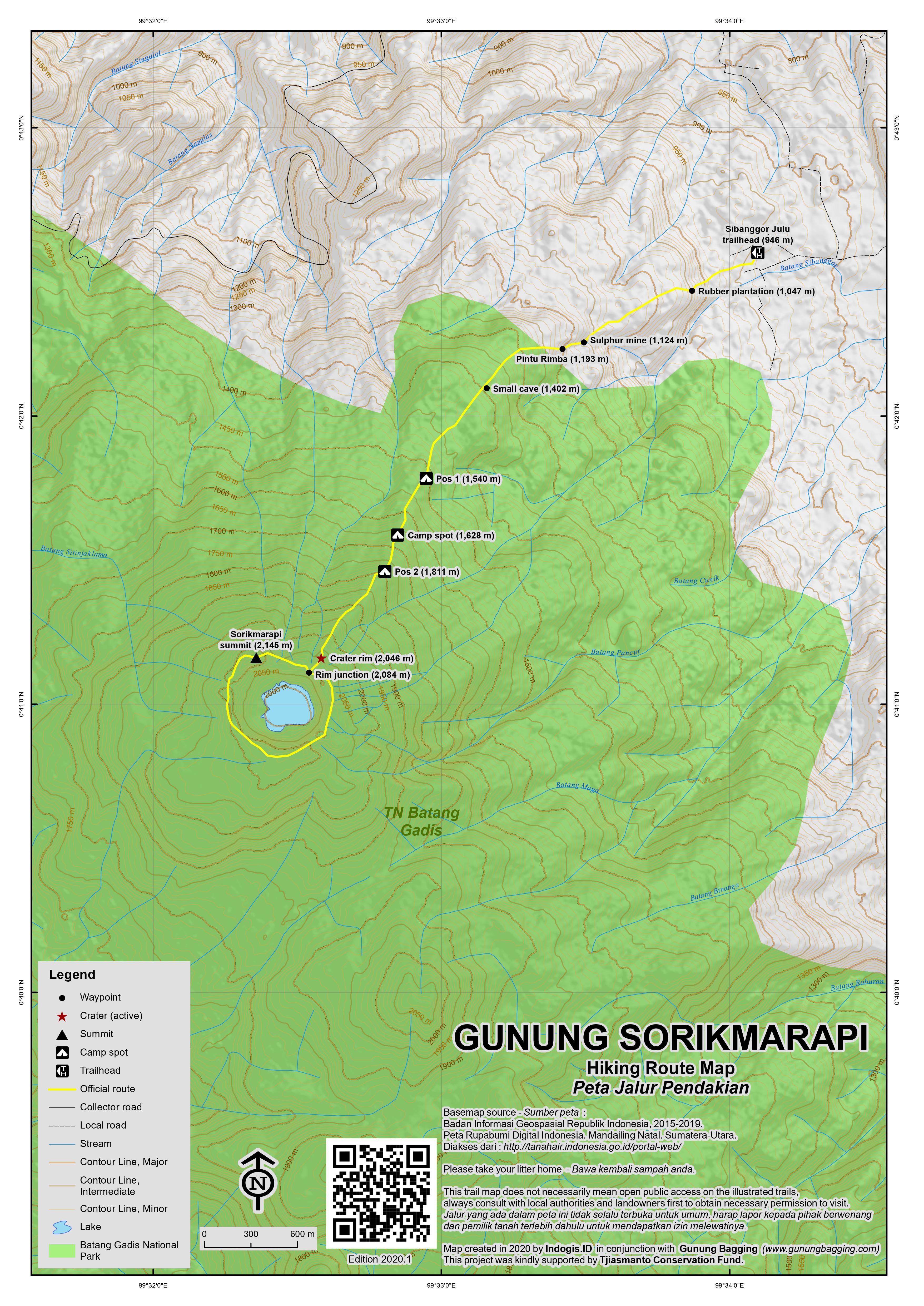
This scenic volcano has 2 crater lakes – the largest of which is called Danau Merah – and is reached from Sibanggor Julu village (946m, apparently written “Singojambu” on some maps) which is beyond the hot springs signposted at Pasar Maga on the Sumatra Highway. It is the highest peak in the Batang Gadis National Park. Strangely, it must be the only mountain in Southeast Asia which women are expressly forbidden from climbing for ‘traditional reasons’. In addition to this peculiarity, the atmosphere in Sibanggor Julu is unfortunately not the friendliest and especially if you are a foreigner you may feel a little unwelcome and then exploited when you are asked to pay several times as much as that of a local hiker. Nevertheless the volcano itself is fantastic and it’s a reasonably straightforward hike which is little-known outside of the local area.
The trail leads up behind the village houses and up a very short, steep section before leading through a plantation of rubber trees (1,047m). Shortly afterwards, you find yourself on bare, volcanic rock in an area used for the mining of sulphur (1,124m). Unfortunately the trail soon enters forest (1,193m) and you do not emerge onto the rim until much higher up (2,046m). It takes about 3 and a half hours to reach the rim from the village and there are a couple of places you could pitch a tent in the forest (at 1,540m and 1,811m) although there are none of the hiking signs usually seen nailed to trees. There are one or two leeches but not enough to make the hike unpleasant.
In clear weather the view of the crater is superb. Two lakes – one large and one small – fill much of the crater floor. It is possible to do a circuit of the rim but it is uncommon and the trail is very unclear in places. To do a circuit takes approximately 90 minutes but take extra care in low cloud and expect to get very dirty clothes! If hiking in a clockwise direction the route is easy enough to follow at first. After some excellent, narrow sections of rim you find yourself on a bushy plateau which is just 5 metres or so lower than the true summit which is on the other side (and saved until the end of the circuit). From here you need to walk right along the very edge of the crater, pulling yourself between bushes with half-burnt and sulphur-coated shrub branches before reaching another little plateau. From here the trail is almost non-existent and you will have to drop down about 40 or 50 metres before clambering over rocks rather than following the crest of the rim (which is probably impossible).
Once you have regained the top of the rim (after a further 30 minutes of tough-going) you need to take a left and double back up to the true high point of the volcano which is marked with a large cement pillar and the remains of a small telecommunications structure. For the less adventurous (or perhaps more sane) hikers, you can simply ask your guide to take you to the ‘pillar’ once you have reached the rim (i.e head anti-clockwise). Heading back to the junction where you climbed up takes just 15 minutes or so (and goes past a tiny cement marker on the edge of the crater at about 2,090m) and from this point you can be back in the village in about 3 hours.
Bagging information by Dan Quinn (May 2013)
Trail Map
For a high quality PDF version of this and other trail maps, please download from our Trail Maps page.
Local Accommodation
Practicalities
- Getting there: It takes about 5 hours to reach the trailhead by car from Bukittinggi. At around 25km away, Kotanopan is the nearest major town on the Lintas Sumatera south of the turning at Pasar Maga though there appear to be no hotels. The situation may be different if you are travelling to/from the north. At Pasar Maga there is a signpost for the hot springs. From the sign it is about 8km up via Desa Hutalombang to the village of Sibanggor Julu though you may have to ask for directions when reaching a couple of minor unsignposted junctions.
- Guides and GPS Tracks: Want a PDF version for your phone? Looking for a guide? Need GPS tracks and waypoints? Gunung Sorikmarapi information pack can be downloaded here.
- Permits: You will definitely be asked to pay a fee in Sibanggor Julu.
- Water sources: High sulphur content in the area so take plenty of your own.
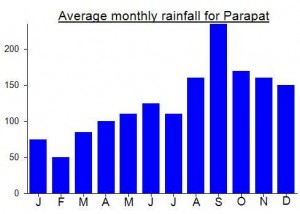
Local Average Monthly Rainfall (mm):
So, not only was Sorikmarapi one of the weirdest hikes of my life so far, it has also turned out to not actually be a Ribu!
A few of us are now working on a Worldwide Ribus list, and as part of this research it has been discovered that nearby Gunung Kulabu (2173m) is the Ribu, so Sorikmarapi is but a mere Spesial!
However good the Sorikmarapi volcano is and however great the views might be in good weather (we were unlucky again) it’s really hard to give a good write-up for the village of Sibanggor Julu. Bad vibes all round!
At certain moments during our preparations for the hike I simultaneously desired to get out of the village as soon as possible whilst also internally remarking how some of the behaviours observed would make Basil Fawlty seem like a fair, sympathetic and mild-mannered character by comparison.
It all started when we arrived after dark on the Friday night. A squadron of village men starting ordering our driver to park up in a particularly regimented way and as I looked out of the window the only people I could see were frowning middle aged men with white Muslim hats on. No smiles. We were escorted into the kepala desa (village head) office next to the large mosque.
On the desk sat an old typewriter – probably more for show than for actual use. The man behind had neatly trimmed facial hair and a half-smug and half-bitter expression suggesting that although he was in charge of the village ‘regime’ he was perhaps here not of his own choosing.
He proceeded to grill each and every one of us – the usual nosey questions that one becomes accustomed to when travelling in Indonesia and having to deal with local bureaucrats. But I could sense that even our driver felt somewhat uncomfortable in the presence of this man who appeared to be using every moment to try to assert his dominance.
He was seemingly not a big fan of foreigners or even those from outside the area but would certainly host them in the village if financial profit was on the cards. The only smiles were smiles of fear as members of our group had to show respect to his relative authority and seniority in accordance with rigid Indonesian societal norms. I was close to intervening and cancelling the whole damn thing.
Amazingly he offered us a place to sleep which turned out to be his own home. Eventually, after making him squirm for a bit during humuorless interrogation, he allowed the driver to leave and head back on the long journey to Padang. We moved to our resting place for the evening, hoping to, you know, actually get some rest. His wife acknowledged our presence but there were no smiles. Once again, out came the cigarettes and I could feel another hour or two of inane interrogation coming on. He obviously wanted to stretch this out as long as possible despite it being 10pm and us needing to wake at 2.30am to start the hike at 3am.
We got out our sleeping bags but he wouldn’t leave us alone! My companion starting doing yoga stretches which to me looked a little too similar to muslim praying but in the opposite direction! I hoped this wasn’t about to make the vibes turn from bad to worse!
Local hikers pay Rp100,000 for a guide which is a reasonable price for what is a reasonably short hike. In daylight you could probably do it on your own with a GPS device. As foreigners we were expected to take a guide each (at 200,000 per guide) plus pay 100,000 for sleeping on the floor (fair enough – if you will let us sleep!) and another 100,000 as a ‘donation’ to the village. As it was late and wanted to get some sleep we reluctantly agreed. I wonder how much of that ‘donation’ did indeed go to the ‘village’…
Next the power goes out so he lights a lamp. Eventually he retires to his bedroom. 5 minutes later he is out again praying right next to us. Why he needs to do it right next to where we are trying to sleep would be a worthy topic for a thesis. He finally finishes praying and returns to his bedroom.
Then his phone starts ringing. It’s in the room where we are. Out he comes to answer it. But he doesn’t go back into his room to hold his conversation. He simply stands right next to us having a loud conversation. After what feels like an eternity finally he disappears.
Then the power comes back on. So he has to come out again to switch off the light! It must have been 11pm by the time we can get any peace from all this and I am no longer in the frame of mind for sleeping – just looking forward to getting the hike done, getting a view at sunrise and getting out of this village.
I should have guessed there could be bad vibes here. The Pemuda Pancasila signs in local villages are not encouraging – just google the group if you are not aware of them and what they stand for. In addition, the fact that females are not allowed to climb the volcano is appalling too and perhaps illustrates the way of thinking that is predominant in the area. Like many problems in Indonesia it stems from great swathes of society being unable to move forward from traditional belief systems concocted centuries ago by men who knew much less about the world than most of us do today. It turns out that if women arrive to hike they are told they must visit the waterfall nearby while the men get on with climbing Sorikmarapi.
The hike itself went fine and the guides turned out to be friendlier than they had been the night before but the weather was poor and there was no view at dawn. It didn’t matter too much – I was looking forward to getting out of the village as soon as possible once we were back down. To try to find some humour in the situation, I wanted to ask if ladyboys or hermaphrodites were allowed up the mountain but our guide understandably didn’t quite get what I was talking about. The older guide was energetic and keen to do a circuit of the rim despite the low cloud and the fact that nobody had done it for 5 years or so and we would inevitably get our clothes pretty dirty.
I saw a few hornbills very close to the trail lower down the mountain but there were also quite a number of local hunters with guns who would clearly eat anything with meat on it.
As often happens, just as I was about to leave thinking the place to be an unusually unfriendly village compared to most in Indonesia, we met a couple of very pleasant and engaging chaps in the local warung who asked us how the hike went etc etc. I let my companion do the talking as I was already thinking about a nice Saturday night meal back at Bedudal cafe in Bukittinggi – and getting the wet socks and shoes off for the final time of the holiday.
Transport was arranged via the kepala desa due to a lack of alternatives. Thankfully we were back over the border in West Sumatra after an hour or so and the world seemed nice again.
I would not wish to especially ‘recommend’ the following people but here are some numbers should you wish to attempt to arrange a hike in advance.
Kepala Desa – 0878 91571788.
A guide – 0813 60825907.
Some information from Mykhailo who is currently travelling from North to South Sumatra climbing pretty much all the interesting peaks along the way…..
Mykhailo Pavliuk “was there in february, the trek took only 2 hours to the crater rim from the last village Sibongor Julu, but it was on extreme hurry due to the thick grey clouds that looked like approached to me side. Normal pace is at least 4 hours by low-grade slope and the trail is clear and not eroded. When you will come to Sibongor Julu you will be guided the “kepala desa” office and asked to make a registration and pay the contribution and given a guide on the same place.”
Another fascinating crater lake in the area is Danau (or Laut) Tinggal up on the slopes of Gunung Malintang (not to be confused with Sago-Malintang near Bukittinggi). This lake is a wonderful light blue colour on Google Earth though not many people hike up to it.
Mykhailo says… “regarding Laut Tinggal. It took more than 4 days, coz we were first on the wrong trail, when fording the full river after heavy rain and that was the main fault. So we took a guide paying 100 000 per day. After last vilage Sitabu you have to walk 15 km. to the last hut by the hot springs called Sosopan and then immidiately steep ascent for about 8 km. to the lake itself. From Sosopan it took us not more than 5 hours, and about 3 hours back. If you want to get there consider at least 3 days too, but the leeches were just too crazy and simply did not release us all the lengh of the trek! it much better to do that in drier season. But, what a marveluos lake is it!”
Definitely one to look into if you have the time and the leech repellant!