Facts
- Elevation: 1,336 m (4,383 ft)
- Prominence: 992 m
- Ribu category: Spesial
- Province: Nusa Tenggara Barat
- Google Earth: kml
- Rating:

 (2 votes) Add your rating
 Loading...
 - Other names: Also spelt ‘Olat Takan’ and known simply as ‘Gunung Takan’ to some locals.
Photos


Bagging It!
Olet Takan is the most prominent peak in the hilly interior of the island of Sumbawa south of the town of Sumbawa Besar. It is not yet popular with hikers and finding anyone who has been to the top remains difficult. However, the area around Ropang is incredibly scenic and it makes a great day out from Sumbawa Besar.
Olet (or ‘Olat’) is the local name for hill or mountain in Western Sumbawa. Further east in the Bima and Komodo areas the local word for hill is ‘Doro’. However, locals also refer to ‘Olet Takan’ simply as ‘Gunung Takan’. There are very few tourists in this part of Sumbawa, and the only foreigners most local people encounter are either surfers or mine workers. Indeed, expect local people to assume you are looking for gold on a mining survey if you ask for them to accompany you into an almost-unknown forest area such as this!
The simple, quiet road from Sumbawa Besar and the northern coast up to the pleasant highland valley of Ropang actually skirts round Olet Takan and reaches almost as high as 1,000m above sea level at one point. This road is, as you might expect, bumpy and pot-holed in places and absolutely fine in other places. The scenery is absolutely gorgeous and beyond the colourfully-painted town of Lantung the hill itself is quite clearly visible as a forested top surrounded by often-parched grassy or bare lands not dis-similar to the evocative landscapes of neighbouring Sumba island.
Indeed, there is even a photo spot at around 900 metres above sea level, known locally as ‘Lenang India’ where you may see folk taking pictures next to a couple of simple shelters. The road gets to within 2 kilometres of the top of Olet Takan on the northern side, but this area is sparsely populated, so finding anyone who might know a way to the top from here is challenging. It is probably possible via coffee plantations but you would almost certainly need to arrange things in advance for a good chance of success.
After skirting round Olet Takan, the road descends into the pleasant, friendly village of Ropang (730m above sea level). This flat valley has cool temperatures by Sumbawa standards and is incredibly scenic, with cattle roaming the flat valley floor, surrounded by forested peaks and covered in rice fields. During the dry season this land is utterly parched with rock-hard, brittle soil, but during the wetter months you can expect to encounter leeches in the forests here.
Sadly, on the western side of the road there is a fair bit of logging going on. The likelihood of hearing a chainsaw or two is high, but it appears not be at industrial levels of destruction just yet. Perhaps the only chance of preserving the forests that remain is by developing eco-tourism initiatives here and certainly Ropang has a lot going for it and may grow in popularity once people know about it.
The best starting point for a hike into the forests of Olet Takan from this southern side of the mountain is from the village of Desa Ranan (733m). This is about 15 minutes beyond Ropang by motorbike (remember to turn left and head east via Desa Lebangkar at the obvious road junction – 782m). Whereas if there were a starting point for the hike on the northern side you would be less than 2 kilometres in a straight line from the peak, here you are a good 5 kilometres or so.
Thankfully, the trek from Desa Ranan to the forest entrance is delightful. About 2.5 kilometres is covered by heading northwards criss-crossing farm fields. Scrubby undergrowth is reached after about one hour (800m above sea level) which may need clearing before you soon enter forest and start properly ascending. There are several hunters’ paths here but none are very frequently used. At the end of the dry season (September-October), the forest vegetation feels fairly spread out and not the usual densely-packed foliage that slows progress down to almost a standstill in wetter areas of the archipelago. So, even though this area is not well-frequented, there remains a clear but vague path up the ridge in most places. In one or two areas you will see evidence of local wood cutting, hopefully for the construction of local houses rather than for selling on in other areas.
Unfortunately, it is not known if a trail leads all the way to the true peak. According to local people in Desa Ranan, the path up the side of the mountain does not go to the summit but simply reaches a lower part of the summit ridge (possibly the 1160m spot height on the Bakosurtanal map 1 kilometres east of the true summit) before heading down to the north to an unclear point on the main road towards Lantung.
In short, the forest trail is occasionally used by locals searching for wood or hunting, or for cutting across the mountain range and emerging on the northern side on the road to Lantung. This seems to be the case for the hills south of the Ropang area too, with a guide saying that Gunung Dinding to the south could be crossed on foot and if you kept on going you would reach the totally undeveloped southern coast in this part of Sumbawa after 15 kilometres or so.
On our trek, we got to within about 1.1km of the true summit, to the east of the peak not far from the col, at which point the local guides said this was as far as they had been before and is what they know as the puncak (peak). Further to the east is another lesser peak which Bakosurtanal suggests is 1,228m high. Given our lack of time we had to return to Desa Ranan, but surely another hour or two and we might have made it to the top of the true peak. One local mentioned there being a cement object (‘semen’) on the true peak, so there is a good chance that there is a triangulation pillar up there from many decades ago – very likely, since neighbouring Olet Sangenges in Western Sumbawa also has one.
According to the Bakosurtanal map, Olet Takan has two peaks about 500 metres from each other, with the western one being 1,328m and the eastern one being 1,336m. Bakosurtanal is not unknown to underestimate heights so even if the mountain is not quite a Ribu, it is certainly close to being a Ribu. More investigation is required and a successful trek would surely only require one full day.
Bagging information by Dan Quinn (September 2019)
Trail Map
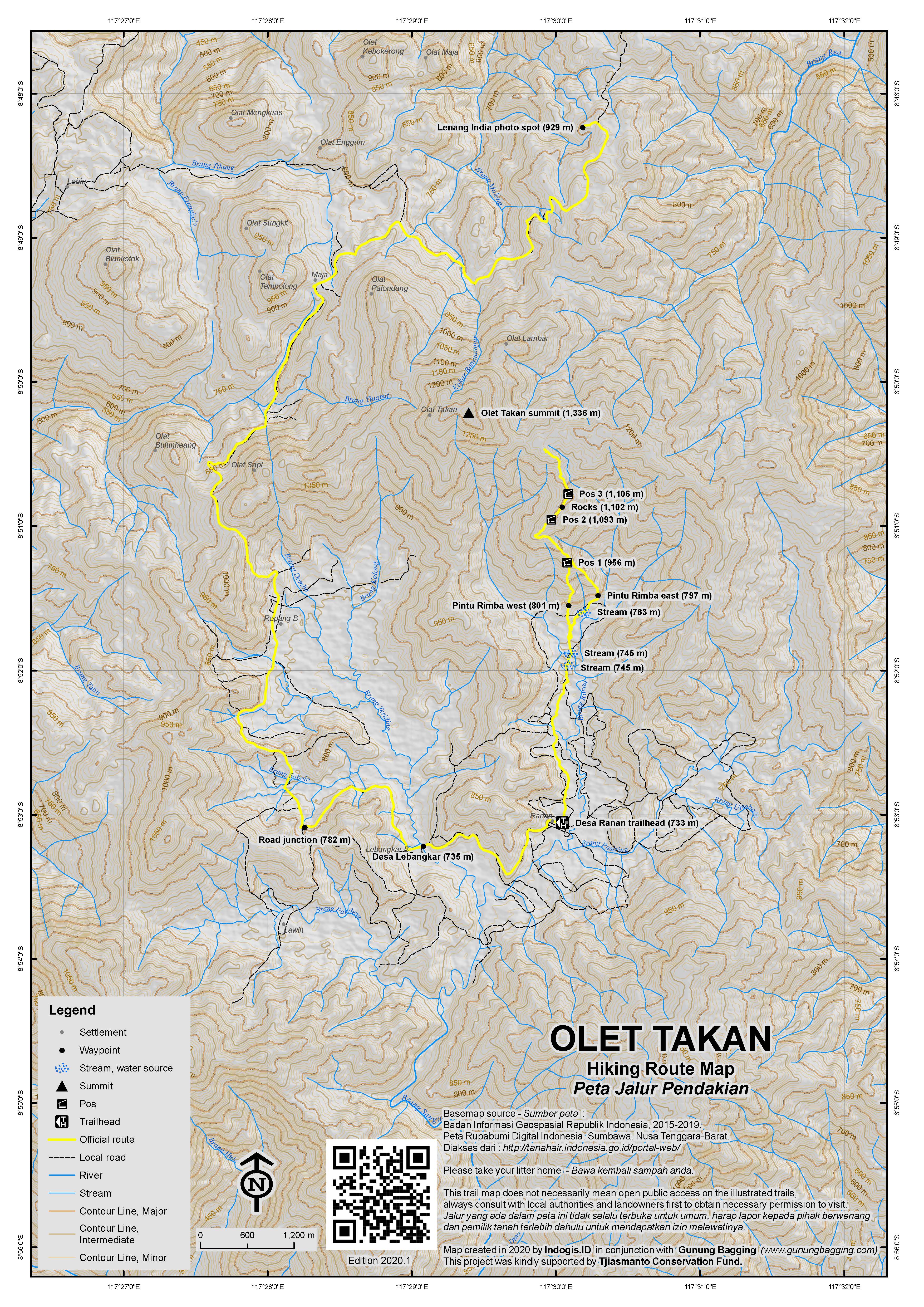
For a high quality PDF version of this and other trail maps, please download from our Trail Maps page.
Local Accommodation
Practicalities
- Getting there: The closest airport is Sumbawa Besar, which is around 2 or 2.5 hours away by motorbike or car. There are buses between Sumbawa Besar and Ropang but anyone on a tight schedule is advised to take private transport instead.
- Guides and GPS Tracks: Want a PDF version for your phone? Looking for a guide? Need GPS tracks and waypoints? Olet Takan information pack can be downloaded here.
- Permits: Register in the local village if starting in the south at Desa Ranan, and ideally take a local guide with you.
- Water sources: None once in the forest – best take sufficient supplies with you.
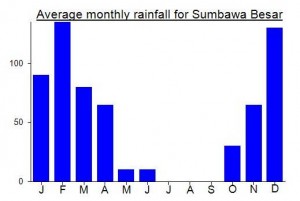
Local Average Monthly Rainfall (mm):
Despite not reaching the top of Olet Takan last weekend, it was a great trip out to an under-rated and barely known part of Sumbawa, which is itself a rather neglected island.
Quite a mad itinerary that most people would think was over the top. Got the first flight from Jakarta to Lombok (0445) then onto the Wings Air short 25 minute flight from Lombok to Sumbawa Besar. Arrived on schedule at 0840, and the very friendly Bang Sahrul was waiting for me with his motorbike for the journey up to Ropang.
Incredibly dry in Sumbawa in September as usual, but truly beautiful landscapes, especially higher up into the hills. There was nobody around to ask about access in from the north, but Sahrul’s friend Yudi had already contacted the village head of Desa Ranan to the east of Ropang so we would try from there.
As mentioned above, most local folk are surprised that a foreigner would come all this way to go for a hike to a remote and unknown mountain peak, an simply assume that you must be working for a mining company! Some Indonesian language skills can help to explain that you are actually just wanting to explore the mountains!
The most knowledgeable guy we encountered in Desa Ranan was Pak Alatip, who claimed to have trekked across the mountain ranges both to the north and to the south and knew the name Takan. After agreeing a fee, we set off (12 noon by now – long journey from Jakarta!). We got as high as around 1,170m and just 1.1km away from the true peak within just under 3 hours. But the guides suggested there was not trail any higher and we were running low on time, so we turned back at this point. You simply need more time – setting out before 9am and you could probably do it comfortably in a day. No hotels here yet but locals will probably be happy to have you sleep on their floor for a fee.
At dusk we were at Lenang India, the photo spot to the north of the peak. Really gorgeous, and there was one moment I didn’t catch on camera as we were already back on the motorbike, when a lovely swirl of cloud twisted round a distant peak as the sun was setting. I should have made the effort to capture this moment but…. Never mind!
It must have taken around 2 hours to get back to Sumbawa Besar. I had already booked the 99 Hotel opposite the airport, so I could simply walk over there the following morning for my return flight to Lombok and on to Jakarta.
I hope some of the local student clubs manage to reach this peak before long. Perhaps they can leave a comment below!
It is great to hear that Olet Sangenges (Puncak Ngengas) is growing in popularity and can possibly be hiked over a long weekend now as the trail is clearer. Just a few years ago there was no information on this at all, but it seems the trail from Marenteh is now used at least once every month or two. This is high on my list, as it’s Sumbawa’s second-highest peak (after the mighty Tambora). A lesser peak on this range called Batu Lanteh is much better known as may be worth a wander if you have an extra day spare.
Many thanks to Yudi and Sahrul.