Facts
- Elevation: 1,774 m (5,820 ft)
- Prominence: 1,143 m
- Ribu category: Kurang Tinggi
- Province: Nusa Tenggara Timur
- Google Earth: kml
- Rating:

 (6 votes) Add your rating
 Loading...
 - Other names: Nuaf Timau
Photos
")
")
")
")
")


Bagging It!
Fatu Timau (1,774m) is a beautiful little mountain that appears pyramid-shaped from many angles. It’s one of the easiest Ribus to bag as its only about 400 metres from the carpark to the summit. Unlike many mountains in Indonesia, mountains in Timor are non-volcanic.
Climbing Fatu Timau used to be a difficult day out from Kupang or Soe, not because of the hike itself but because of the quality of the rural roads. However, in 2021, the route has been completely resurfaced and it is easy to reach the mountain. Nevertheless, few foreigners or even locals visit this area so don’t be surprised if they are bemused to see you!
The Indonesian press reported in 2015 that an Observatory would be constructed on hills nearby Fatu Timau but apparently not on the summit itself. In 2021 this project remains half-completed but will be finalised soon.
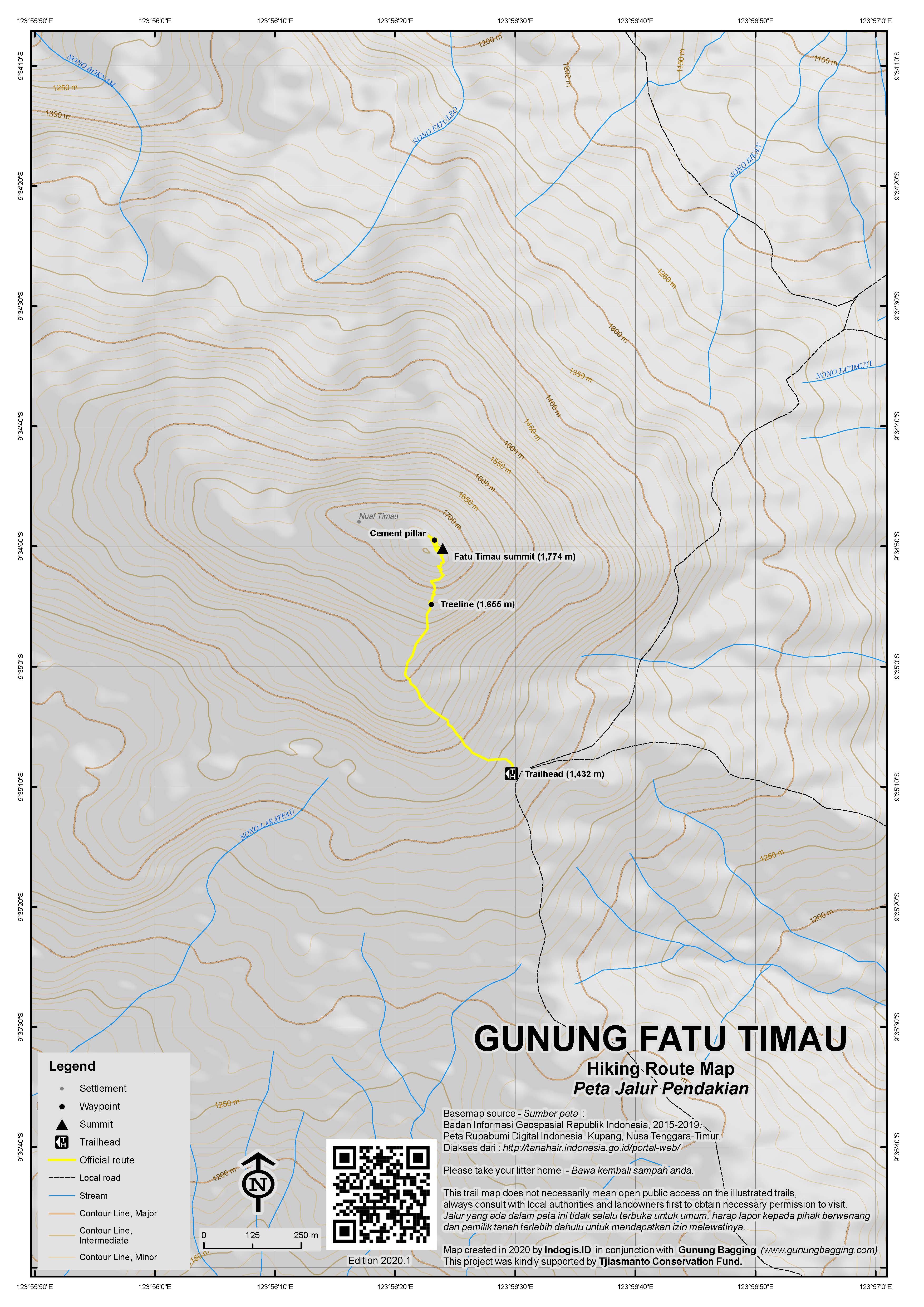
A trekking guide is not strictly necessary although as usual it is best not to go alone. Ensure that the driver knows the Takari turn-off on the highway, and the road to Lelogama and, further on, to Amfaoang. After Amfaoang, and passing through spectacular rolling hills, you reach a T-junction with a small shop on the left-hand corner. Stop here for a coffee and catch up on local news about Fatu Timau. Beyond this point, the road is obvious as the mountain comes into view.
Eventually, you will reach the highest point (1,432m) of the road that skirts the mountain. This point is obvious when you reach it! Park your vehicle here. The climb to the summit of Fatu Timau is just over 1.5 hours up from here.
rom the highest point on the road, walk back down some 40 meters to a small gully. Here, you should be able to pick up a cattle track that leads up to the left (look for trees we blazed – June 2015). After several hundred metres, you might be lucky to pick up another cattle track that leads you back to the right and onto the main ridge leading up to the peak. With luck, if the cattle tracks are clear, you should be able to avoid most of the undergrowth and rock out-crops at the start of the climb. The cattle here are smart – they know the easiest way up the mountain – follow their tracks and dung wherever possible.
After about one hour, you will emerge onto the open, rocky mountainside (1,655m). (Make a mental note of where to re-enter the undergrowth for your descent.) The way upwards is zig-zagging over broken, limestone rocks to the summit. Again, the cattle know the easiest way up the mountain so follows their tracks wherever possible.
The summit of Fatu Timau is rocky, no trees. It offers wonderful, unimpaired, 360 degree views from the east to west coasts of Timor. Gunung Mutis, the highest peak in West Timor, is visible to the north. Fatu Timau is crowned with a broken cement trig pillar. The metal geodesy marker on a nearby rock had gone missing (June 2015). Bakosurtanal maps label the peak as ‘Nuaf Timau’ with a height of 1,779m.
You can be back down at the road in 45 minutes or so, before starting on the epic journey back to the Kupang-Soe highway. This return trip is a wonderful experience in the late afternoon as the sun is getting lower in the sky.
Fatu Timau might be regarded as a mountain only for the fanatical, yet with the incredible scenery – rolling grassy hills, horses and cattle grazing on pastures amongst the hills, traditional Timor villages of huts, local people chomping on betel nut – it makes for an excellent day out into the wilderness of West Timor. Highly recommended!
Bagging information by Daniel Quinn (August 2011); updated by Nick Hughes (June 2015)
Gunung Fatuleu (1,108m)
A much more popular and more accessible mountain from Kupang is Fatuleu, which is 1,108 metres high according to the Bakosurtanal map. It’s a very worthwhile half-day out from Kupang, taking about 90 minutes to reach the trailhead and a further hour to get to the top, if you are brave enough.
Fatuleu means ‘prayer rock’, and in previous times was a place where traditional leaders went to sacrifice animals and pray, for example for rainfall. The mountain is the imposing highest peak in a large area full of karst cliffs.
The trail starts at the car park (855m) where you might typically pay Rp5,000 for parking a motorbike or Rp10,000 for a car. The best times for photographs are dawn and dusk and although there may be no officials with tickets at 6am it is still possible to visit.
The first part of the trail is on cement steps past several pleasant traditional shelter and resting areas. The steps end at around 950m and the trail leads up through the jumble of karst rocks and forest. The really rocky part begins at 990m and there are some wonderful viewpoints here but do take real care with all the holes between the boulders. In the distance to the north you should be able to see Fatu Timau and in the opposite direction is the sea and the city of Kupang.
Working your way through the rocks you finally reach a near-vertical bare rockface (1,052m). Most visitors stop here, or even lower down, but the nimble, brave and experienced can continue on the dangerous climb up narrow ledges to the summit (1,108m). Most hikers can be at the base of the summit cliffs in about 45 minutes or less from the trailhead, so allow an hour (one way) to reach the true summit but take extreme care if attempting it.
Trail Map
For a high quality PDF version of this and other trail maps, please download from our Trail Maps page.
Local Accommodation
Practicalities
- Getting there: There are plenty of buses on the main Kupang-Soe road but you still have a huge distance to cover on poor tracks. It’s best to arrange transport in Kupang beforehand (4WD if possible) rather than trying to get lucky with ojek driver who may not nknow the way or be happy with the terrain and/or distance. From Kupang, it’s about 90 minutes to Takari where you take a bumpy track inland (opposite the police station) towards Lelogama (not signposted). After Lelogama you will almost certainly need to stop and ask locals who may or may not speak Bahasa Indonesia, let alone English! That’s why taking a guide is well worth it. From the Takari turning it takes around 4 hours to reach the shoulder of the mountain.
- Guides and GPS Tracks: Want a PDF version for your phone? Looking for a guide? Need GPS tracks and waypoints? Fatu Timau information pack can be downloaded here.
- Trip planning assistance: Would you like Gunung Bagging to personally help you in arranging your whole trip? Please contact us here.
- Permits: None required.
- Water sources: There is no water on the hike and there are no shops anywhere near the mountain. Make sure you buy drinking water before you turn off the main Kupang-Soe road.
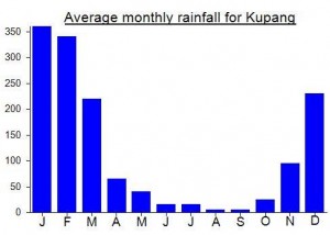
Local Average Monthly Rainfall (mm):
Location
Origins and Meaning
Literally ‘the rock of Timau’ – Timau is the name of a place nearby. (Gabriel Faimau, 2011)
https://www.ii.uib.no/~petter/mountains/1500mtn/timau.html
Interesting report. The observatory construction is obviously well underway now, but could this be a new reason to prevent hiking access?
Just went up to Fatu Timau / Nuaf Timau on Monday. The road from the Takari turn-off is now a nice, broad asphalt road (apart from 3 bits of roughly 100m long each, which have been washed away by the April 2021 Seroja storm floods). We were seemingly the very first tourists who took the last 15 km of the road because it was still a pristine black color and lots of heavy road-making equipment was parked alongside it. It was smooth as a pool table! It took just about 1.5 hrs from the Takari turn-off to the observatory, which is located 400m from the foot of the Fatu Timau peak forest. The observatory is not yet completed (construction was interrupted in April 2020 due to covid) but they will finalize it soon. Although there was a thick milky haze preventing us from seeing in the distance, I’m happy to share photos of the approach if you want
Had a great few days on Indonesia’s southernmost island of Rote this week. Some incredible beaches, friendly people, and almost totally deserted at the moment. The best way of seeing the island is to hire a car there. The day we came back I decided to visit Fatuleu before flying home from Kupang… fabulous at dawn, but I was too scared to climb the last 50 metres to the summit, you need to be very careful up there indeed! At present the Google Maps directions are still wrong – wait until you reach Camplong on the main road before turning left….
Most people in Kupang don’t realy know this fatu Timau (Timau Stone Mount) or where it is. But you can get much information form native people from District Amfoang (Kecamatan Amfoang) who lives in Kupang residance. I guaranted.
Hi..I’m Johan Littik. I know this place is. Although I’m a Rotiness and live in Kupang but I’ve been there many times to visit this fatu Timau as I have a related family those live in a village that near by the Mountain, called Bioba village. Fatu (in Local language)and Batu (in Indonesian) means Stone. Timau is a local name of the mountain. I’m so happy and amazing to hear that you all as foreigners had been visit this fatu Timau. Yes you are right that about 6 hours from Kupang as I use a motorbike to take there with bumpy tracks and a beautiful panaoramas on the way. All information you wrote is so right ata the momment situation and condition. Fatu Timau is a subdistric of Amfoang (kecamatan Amfoang) which is in Kupang residence. I’m as one of local peaple we shame with the roads condition (rocky/muds) to get there, but now local native have eat rice for meals, clean water to boiled first. So you dont have to hurry back to Kupang so you can have a rest in local house before night comes. You know why the distric condition like this, it’s because the Kupang residence is too huge area, so they just start to develope litle by litle. However in a 2016 goverment planing, Amfoang Subdistric will be separated from Kupang residence, and it will be built by their own policies. And 1 of the Main road is through near the Fatu Timau to Border with Timor Leste, is called Jalan Poros Tengah means Centre Main road. And one day in local area they will build a Planetarium (binoculars to look the stars). One day this place will be easier to people come. I wish. My number 08113828054 or 085239720353.
I traveled to Fatu Timau starting from Soe. I happily recommend my driver, Apris (085239729795) and his 4WD Ford.
From Soe to Takari along the main road took us 1 hour; the turn off to Lelogama is clearly signed about 100m west of a large Pertamina station. From the turn off to Fatu Timau took us 4 hours even with the 4WD. I’m astonished that a Kijang could make it through at all; you’d have to pay me the price of the car to get me to take my Kijang up there!
There are several warungs in the villages along the road; at the shop where you turn left a few km beyond Lelogama you can even buy mountain-cooled Bintang!
Like Dan, I found the hike thoroughly enjoyable, although the promised cow dung failed to materialise in the quantities anticipated. The first push up to the ridge definitely takes determination. Exploring later, I found that there is actually a path into the forest, starting about 40 meters before the high point of the road. Initially it heads in the wrong direction, away from the summit, but after a couple of hundred meters it curves round to the right and brings you back up onto the desired ridge at the point where the trail becomes readily discernible.
It would be good to have a machete, or even colored ribbon, to mark the trail in the thick vegetation on the upper section of the ridge and to help you find the way back down. In misty conditions, as I experienced, navigating back from the summit over the exposed rocky section is also tricky; a GPS device, or else very great care, is required to ensure that you can find the reentry point to the forest.
Time for the whole hike from our parking spot at the high point of the road was 2 hours 30 minutes.
I back up Dan’s advice about starting as early as possible. We started late and ended up driving most of the way back in mist and darkness, which is tricky on the rough sections above Legolama. A pleasant alternative would be to spend the night in a local house or to camp in the pastures, though you would have to rent your car for an extra day.
What a great find! The journey to Fatu Timau is fantastic. If trail bikes were/are available in Kupang, this would be one best rides in Indonesia.
Dan’s bagging info get’s the facts right, but the road is not that bad and the scenary is fantastic and makes up for the bumps. We stopped to take photos many times – karst outcrops, traditional houses, semi-wild horses, cacti – and we arrived at the trailhead in 5 hours in a Kijang. The return was quicker and we stopped for dinner.
The trail to the summit is easy to follow; the first 10 minutes is where the trail is most uncertain. But you really can’t go wrong. From the rocky summit we could see the north coast of Timur and Gunung Mutis to the south – at this time of year it is pretty hazy, and would be fantastic the the day after a rainstorm. We particularly enjoyed hiking through the eucalyptus forest, with crunch of dry leaves underfoot and distinctive smell.
A 4-wheel drive would seriously reduce the drive time, so definitely ask about this in Kupang. We used the same guide as Dan (Ony), but he is expensive and likes to use the drivers he knows. The driver we used (Forkus) is excellent and his Kijang stands up to the road very well. It would be much cheaper to just use Forkus since he knows the way and hiked to the summit with us (Forkus is a big guy, which shows how easy the trail is).
We can’t recommend Timur and Rote enough as a holiday destination. Off the well worn tourist trail, but easy and full of great people.
Climbed this great little peak yesterday. Arriving in Kupang the afternoon before I was slightly surprised that nobody seemed to have heard of it. Finally Edwin who runs the L’Avalon hostel and ramshackle bar on the waterfront (frequented by lots of interesting intellectual characters from the nearby island of Roti) put me in touch with Ony Meda, a great local guide. He’d heard of the mountain but had never climbed it and didn’t know of anyone who had! But he was up for an adventure so we arranged transport (bloody expensive in this part of the world). On Google Earth I had spotted a small track just 1km from the actual peak so I was hoping access would not be too much of a problem. Ultimately it wasn’t – if you don’t mind sitting in a car for 6 hours over bumpy tracks! It took us 6 hours from Kupang to the foot of the beautifully shaped mountain and then just one hour to the peak itself which means it’s the second easiest Ribu to climb (after the ludicrous Keli Lepembusu, also in NTT). Whilst the bumpy journey to the mountain is no recommended for those who got drunk at the bar the night before (I put my hand up) it is definitely one of the most fascinating and scenic journeys I have ever made in Indonesia (although a 4WD would be preferable if you can afford it). It gets about as wild as Timor gets, as the dirt track leads through grassy, almost Autumnal scenery similar to the Northern Territories of Australia, beautiful white-trunked Eucalyptus trees, wild horses and villages whose inhabitants chew on the betel nut and live in the beautiful traditional ‘beehive’ houses. The track affords wonderful panoramic views and skirts around a few interesting rock cliffs. and There is also a great deal of birdlife.
The mountain itself is very very infrequently climbed but cows wander up to the top so there is a vague trail up there. The last bit is great – clambering over limestone boulders to the peak which is crowned with a broken cement trig point. The views over to the Mutis mountains are tremendous.
I’m in Soe at the moment – off to Fatumenasi today to climb Mutis tomorrow. A proper trip report for this mountain will be coming soon.