Facts
- Elevation: 2,885 m (9,465 ft)
- Prominence: 1,551 m
- Ribu category: Tinggi Sedang
- Province: Nanggroe Aceh Darussalam
- Google Earth: kml
- Rating:

 (5 votes) Add your rating
 Loading...
 - Other names: none
- Eruptions: Bur ni Telong 1937
Photos


Bagging It!
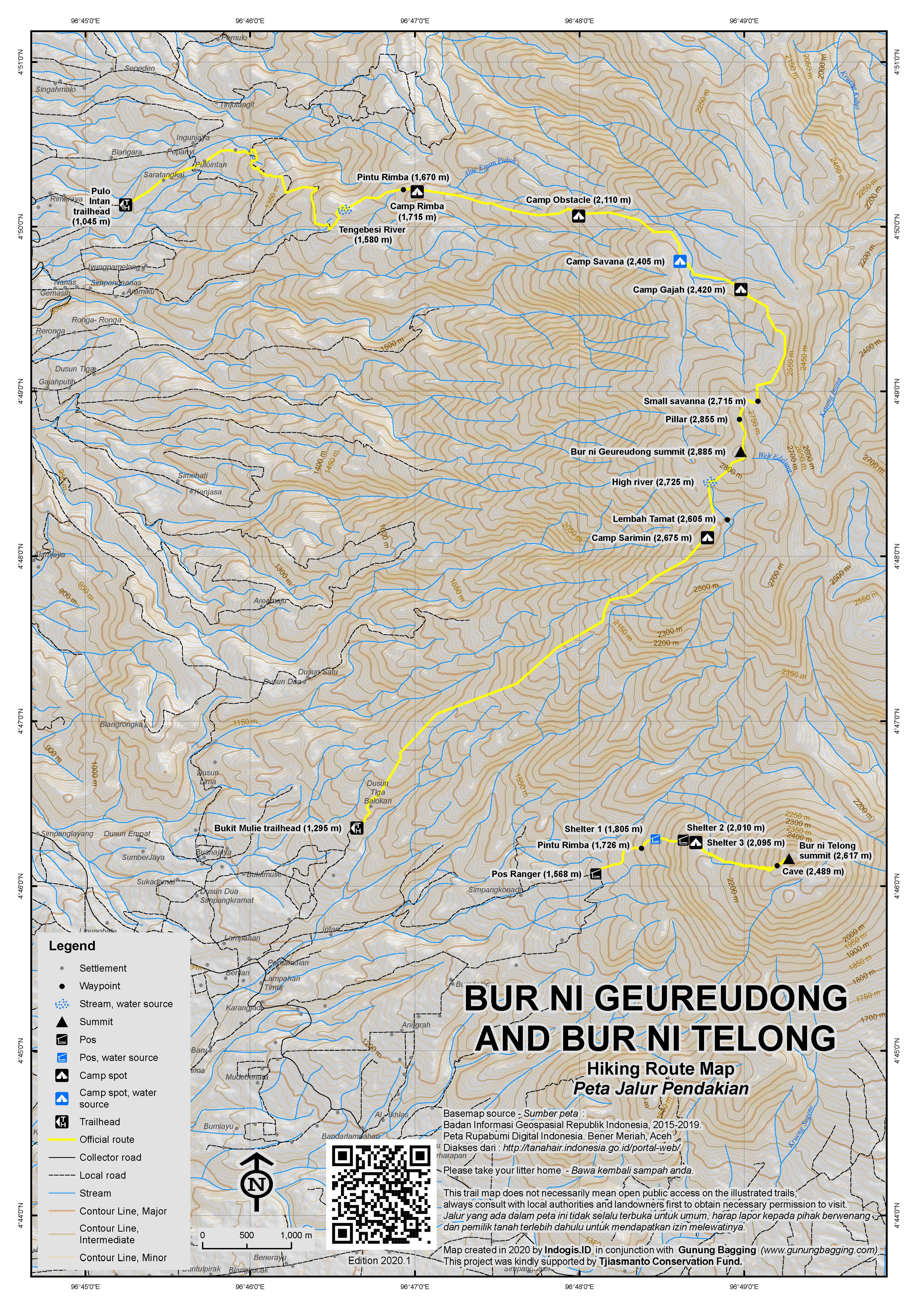
Bur ni Geureudong is a large forested mountain range which is occasionally hiked by local university hiking clubs on expeditions that take a minimum of 5 or 6 days. There is an old triangulation pillar at 2,855m about 400 metres north of the true summit. There are apparently some fascinating megaliths and also hot springs on its slopes.
From the northern trailhead at Pulo Intan (1,045m), the trail leads via Sungai Tenggebesi (1,580m), Pintu Rimba (1,670m), Camp Rimba (1,715m), Camp Obstacle (2,110m) before reaching Camp Savanna (2,405m) where there is a water source. Continuing on towards the summit is Camp Gajah (2,420m), a Small savanna (2,715m) and then the pillar peak at 2,855m.
South of the pillar peak is the true summit at 2,885m. Dropping down to the southern trailhead, you pass via a water source (‘high river’, 2,725m) overlooking and indeed flowing down into Lembah Tamat, Camp Sarimin (2,675m) before heading all the way down to the south-west at the Bukit Muie trailhead (1,295m).
Bur ni Telong
At the southern end of the range is the striking Bur ni Telong (2,617m), a historically active volcano complex which is climbed frequently (and separately from Geureudong) and the summit of which offers great views and can be reached in a few hours.
Bur ni Telong is perhaps Aceh’s most popular hike, with a decent registration post at the trailhead, accurate signs and a straightforward trail. Local students climb to the top every weekend, but even on weekdays you are likely to meet other hikers on the trail. Pos Ranger (1,568m) is the place to start – a building at the top of a minor road up from the main Bireuen-Takengon road at Lampahan. Motorbikes can be left here for a small fee, and possibly even a car or two.
The best time to enjoy the views from the top of Bur ni Telong is just after sunrise. Therefore, most hikers camp at one of the most suitable places on the trail. However, it may be possible to find a local guide who is willing to set off at, say, 1.30 or 2am in order to reach the top just after 6am.
From Pos Ranger, the route follows a paved path which can be a little slippery up through a coffee plantation. Within 30 minutes you should have reached Pintu Rimba (1,726m) which is the forest entrance. Shelter 1 (1,805m) follows soon after and down to the left of the trail is the last water source on the mountain. Shelter 2 (2,010m) and Shelter 3 (2,095m) follow soon after, and most hikers will have reached Shelter 3 in 2 hours or less. As with all the shelters, there are no actual buildings to shelter under, but of the three, Shelter 3 is probably the best area for spending the night camping as there are plenty of flat spots and if the weather is fine then also a view of the top of Bur ni Telong on the left.
If you have camped at Shelter 3 and want to reach the top for sunrise then the best time to leave is between 3 and 4am, depending on your speed. Sunrise here is not until around 6:30am but the sky lightens nicely from around 6am. Fast hikers can be at the top in two hours, but many will take a little longer.
Not long after Shelter 3, the end of the forest is reached, and the views are open from here all the way to the top. It is beautiful at night, with the constellations overhead, and also great during the day when you can see the slightly higher Geureudong massif over to the left (north) and down to Rembele airport and beyond to Takengon the right. There are lots of edelweiss plants here.
About 20 minutes short of the peak is a small cave (2,489m) on the right which would be ideal for basic shelter in poor weather. Just beyond this cave is a roped section of trail where care is required as you pull yourself up over steep rock. The summit itself (2,617m) is on the edge of a steep cliff and it is quite clear from the jagged shape of the higher part of the mountain that this was once a fearsome volcano capable of powerful activity. It appears that there has been little activity here since 1937, but that is not to say that there will be no more in the future.
The views are brilliant, with numerous forest-clad peaks in all directions, including Bur ni Kelieten just on the other side of Danau Laut Tawar. It is a shame there is no trail between Telong and Geureudong as they are part of the same range and it would be great to be able to do both together. Perhaps that’s a plan for the future.
Fit hikers can be back down at Shelter 3 in about 1 hour, and need just another hour from there to reach the trailhead.
Bagging information by Dan Quinn (April 2018).
Thanks to Maria Angela H for information on Bur ni Geureudong practicalities.
Trail Map
For a high quality PDF version of this and other trail maps, please download from our Trail Maps page.
Local Accommodation
Practicalities
- Getting there: The closest airport is Takengon’s Rembele airport which (in 2018) has a daily Wings Air flight from Medan. From here you are less than 30 minutes from the mountain. You can also fly to Lhoksumawe which is about 3 hours away. For Geureudong: From Bireuen to Simpang Kompi on the Bireun-Takengon road, then 25 minutes to Bukit Mulie village. For Telong: Follow the minor road up to Pos Ranger from Lampahan.
- Guides and GPS Tracks: Want a PDF version for your phone? Looking for a guide? Need GPS tracks and waypoints? Bur ni Geureudong information pack can be downloaded here.
- Permits: As always, take a photocopy of your passport photo page or ID card. For Telong, register at Pos Ranger (Rp 10,000 per person). For Geureudong, you need permission from the head of the village.
- Water sources: For Geureudong: There are 3 water sources. Tengebesi River near resident’s fields, Water Springs at Savanna , and River at around 0,6km from the Bur ni Geureudong second peak. For Telong: Available about 50m from Shelter 1 (1,800m).
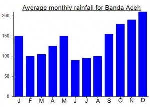
Local Average Monthly Rainfall (mm):
Location
Origins and Meaning
‘Geureudong’ may mean a sound like thunder (Mark Durie, 2011).
Have obviously wanted to do Geureudong itself but haven’t had the time yet but thought Bur ni Telong would be very much worth a go. It was indeed! Thanks to Maria Angela who put me in touch with her friend Bang Dipa from Mapala Alaska at Bireuen. He picked me up at Lhoksumawe airport and we went to his campus to chat and prepare for this hike and also to Bur ni Kelieten. Only 30 minutes or so fro Lhoksumawe airport but a good 3 hours or more from Bireuen to the trailhead near Lampahan. I was very surprised to see a proper trail map and seemingly accurate elevation data. Apparently this is the most popular hike in Aceh.
Being utterly knackered from jetlag after having returned just a couple of days before from the UK it was tough going for me, but in normal conditions this would be an easy trail for most…. short, clear and well sign-posted. Lots of siamangs to listen to here, too.
We had great weather so the views the following morning were fantastic. One other small group with us up there but I can imagine weekends can get pretty noisy indeed. Geureudong looks tantalisingly close and I could well be back for that 5 or 6-day trek next year or the year after. It’s less than 300 metres taller but is, crucially, the Ribu, the ‘mother of the mountain range’.
It was unusually hot for over 2600m – but perhaps that was just me, having recently returned from the UK. As the sun came up, there was the Brocken spectre effect of me on the clouds opposite as I waved my arms up and down.
Bang Dipa spotted a snake at around 2,100m on the way back down which he thought was a cobra but I didn’t want to get a good look at for obvious reasons! One or two pitcher plants but not as many as on Kelieten the following night.
After a successful hike up Bur ni Kelieten I flew back to Medan from the little Rembele airport which was extended in 2016. What an amazing view of Bur ni Telong from the airport itself – especially from the entrance firstthing in the morning. There aren’t many airports in Indonesia with such a fine mountain view. If there was an afternoon flight out of Rembele you would actually be able to do Bur ni Telong as a weekend trip from Jakarta. As it is, you need a third day to get back out.
One thing to bear in mind however is the rules at the trailhead. Very restrictive, moralistic and nosey, but then this is Aceh where seemingly everything about your private life is not private at all. No male with female trekkers unless with a guide from the local Rembune village (would being married make this different? not sure). Fine:Ten Million rupiah! Aside from this stuff, this is a really enjoyable trek.